Property Record
4401 W Memorial Rd, Oklahoma City, OK 73134
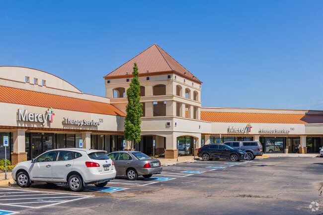


This Property Is For Sale
NEARBY LISTINGS FOR SALE OR LEASE
Property Detail
4401 W Memorial Rd
Oklahoma City, OK
Unpltd Pt Sec 11 13N 4W
140726100
UNPLTD PT SEC 11 13N 4W 000 000 PT SW4 SEC 11 13N 4W BEG 455FT N SW/C SW4 TH N390FT E50FT N473.28FT E930FT S37.35FT TH ALONG CURVE TO RIGHT 206.56FT THSW465.33FT TH ALONG CURVE TO LEFT 172.44FT TH SE35.36FT TH W ALONG R/W LINE 747.75FT TO BEG EX 4 TR
Regionalshoppingcenterormallwithanchorstore
Oklahoma
AE
Oklahoma
40109C0155H
1-3
2023
10.47 AC
2024
Northwest
108534
Oklahoma City
90,228 SF
DEMOGRAPHICS near 4401 W Memorial Rd
1 Mile
3 Mile
5 Mile
2024 Total Population
4,044
63,131
174,322
2029 Population
4,138
64,968
179,901
Pop Growth 2024-2029
+ 2.32%
+ 2.91%
+ 3.20%
Average Age
45
39
38
2024 Total Households
1,739
28,160
73,331
HH Growth 2024-2029
+ 2.42%
+ 3.06%
+ 3.16%
Median Household Inc
$100,094
$76,257
$72,436
Avg Household Size
2.20
2.20
2.30
2024 Avg HH Vehicles
2.00
2.00
2.00
Median Home Value
$353,625
$259,993
$236,695
Median Year Built
1993
1992
1988
Nearby Places
Map Layers
Map Styles
 Street
 Aerial
- Restaurants
- Banks
- Shops
- Fitness
- Groceries
PUBLIC TRANSPORTATION
AIRPORT
Will Rogers World
DRIVE
WALK
Distance
Will Rogers World
30 min
17.9 mi
Freight Ports
Tulsa Port Of Catoosa
DRIVE
WALK
Distance
Tulsa Port Of Catoosa
132 min
122.0 mi
Nearby Properties
Address
Land Use
TOTAL SIZE
Lot Size
Zoning
Address
Land Use
TOTAL SIZE
Lot Size
Zoning
60,267 SF
0.88 AC
C-3
Address
Land Use
TOTAL SIZE
Lot Size
Zoning
823,638 SF
94.89 AC
PUD
Address
Land Use
TOTAL SIZE
Lot Size
Zoning
140,312 SF
7.91 AC
C-3
Address
Land Use
TOTAL SIZE
Lot Size
Zoning
294,327 SF
14.04 AC
PUD
Address
Land Use
TOTAL SIZE
Lot Size
Zoning
460,954 SF
24.83 AC
PUD
Address
Land Use
TOTAL SIZE
Lot Size
Zoning
594,334 SF
71.64 AC
C-3
Address
Land Use
TOTAL SIZE
Lot Size
Zoning
41,733 SF
2.63 AC
O-1
Address
Land Use
TOTAL SIZE
Lot Size
Zoning
41,733 SF
2.47 AC
C-3
Address
Land Use
TOTAL SIZE
Lot Size
Zoning
414,006 SF
22.80 AC
PUD
Address
Land Use
TOTAL SIZE
Lot Size
Zoning
376,079 SF
29.77 AC
PUD
Address
Land Use
TOTAL SIZE
Lot Size
Zoning
8,354 SF
16.65 AC
PUD
Address
Land Use
TOTAL SIZE
Lot Size
Zoning
333,436 SF
22.82 AC
PUD
Address
Land Use
TOTAL SIZE
Lot Size
Zoning
184,238 SF
7.35 AC
C-3
Address
Land Use
TOTAL SIZE
Lot Size
Zoning
10,811 SF
1.46 AC
PUD
Address
Land Use
TOTAL SIZE
Lot Size
Zoning
358,436 SF
18.03 AC
PUD
Address
Land Use
TOTAL SIZE
Lot Size
Zoning
247,230 SF
22.75 AC
PUD
Address
Land Use
TOTAL SIZE
Lot Size
Zoning
10,635 SF
1.49 AC
PUD
Address
Land Use
TOTAL SIZE
Lot Size
Zoning
297,836 SF
15 AC
PUD
Address
Land Use
TOTAL SIZE
Lot Size
Zoning
302,058 SF
23.78 AC
PUD
Address
Land Use
TOTAL SIZE
Lot Size
Zoning
227,714 SF
14.15 AC
PUD
Address
Land Use
TOTAL SIZE
Lot Size
Zoning
294,250 SF
17.85 AC
PUD
Address
Land Use
TOTAL SIZE
Lot Size
Zoning
291,228 SF
14.15 AC
PUD
Address
Land Use
TOTAL SIZE
Lot Size
Zoning
255,921 SF
9.93 AC
PUD
Address
Land Use
TOTAL SIZE
Lot Size
Zoning
356,798 SF
31.11 AC
C-3
Address
Land Use
TOTAL SIZE
Lot Size
Zoning
158,078 SF
15.58 AC
PUD
Address
Land Use
TOTAL SIZE
Lot Size
Zoning
224,984 SF
12.72 AC
PUD
Address
Land Use
TOTAL SIZE
Lot Size
Zoning
191,504 SF
20.03 AC
PUD
Address
Land Use
TOTAL SIZE
Lot Size
Zoning
235,612 SF
28.09 AC
PUD
Address
Land Use
TOTAL SIZE
Lot Size
Zoning
316,212 SF
16.36 AC
PUD
Address
Land Use
TOTAL SIZE
Lot Size
Zoning
279,215 SF
11.58 AC
PUD
The World's #1 Commercial Real Estate Marketplace
Connect with us
© 2025 CoStar Group
The information above has been obtained from sources believed reliable. While we do not doubt its accuracy we have not verified it and make no guarantee, warranty or representation about it. It is your responsibility to independently confirm its accuracy and completeness. Any projections, opinions, assumptions, or estimates used are for example only and do not represent the current or future performance of the property. The value of this transaction to you depends on tax and other factors which should be evaluated by your tax, financial, and legal advisors. You and your advisors should conduct a careful, independent investigation of the property to determine to your satisfaction the suitability of the property for your needs.