Property Record
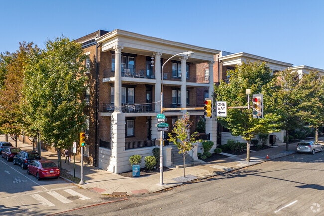
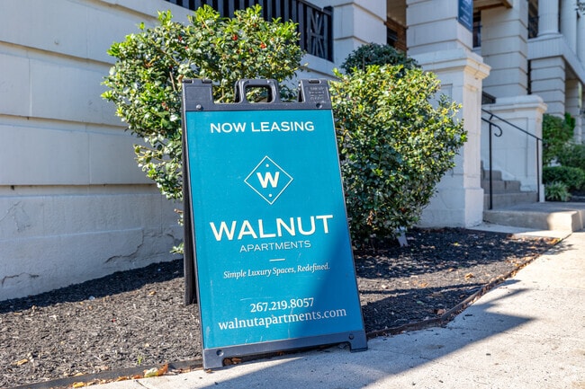
4401 Walnut St, Philadelphia, PA 19104
NEARBY LISTINGS FOR SALE OR LEASE
-
-
-
-
-
-
-
-
-
-
-
No Photo
-
-
-
-
-
-
-
-
-
-
-
-
-
-
-
-
-
-
-
-
View all Philadelphia listings for sale on LoopNet.com
Property Detail
4401 Walnut St
Philadelphia-Camden-Wilmington, PA-NJ-DE-MD
Clermont Apts
881121800
; 34 UNITS 17,228 SQ FT
Apartment
Philadelphia
X
Pennsylvania
42045C0150F
93
2024
0.39 AC
2026
Spruce Hill
008701
Philadelphia
33,434 SF
DEMOGRAPHICS near 4401 Walnut St
1 Mile
3 Mile
5 Mile
2024 Total Population
73,547
488,813
955,865
2029 Population
71,978
477,272
937,639
Pop Growth 2024-2029
(2.13%)
(2.36%)
(1.91%)
Average Age
33
37
37
2024 Total Households
30,106
213,188
403,178
HH Growth 2024-2029
(2.41%)
(2.65%)
(2.18%)
Median Household Inc
$40,254
$53,258
$58,045
Avg Household Size
2.10
2.10
2.20
2024 Avg HH Vehicles
1.00
1.00
1.00
Median Home Value
$274,716
$231,062
$249,856
Median Year Built
1948
1948
1948
Nearby Places
Map Layers
Map Styles
 Street
 Aerial
- Restaurants
- Banks
- Shops
- Fitness
- Groceries
PUBLIC TRANSPORTATION
TRANSIT/SUBWAY
Baltimore Avenue And 44Th Street (Route 34 - Southeastern Pennsylvania Transportation Authority Rapid Transit (SEPTA Subway & Trolley))
DRIVE
WALK
Distance
Baltimore Avenue And 44Th Street (Route 34 - Southeastern Pennsylvania Transportation Authority Rapid Transit (SEPTA Subway & Trolley))
1 min
8 min
0.4 mi
46Th Street (Market-Frankford Line - Southeastern Pennsylvania Transportation Authority Rapid Transit (SEPTA Subway & Trolley))
DRIVE
WALK
Distance
46Th Street (Market-Frankford Line - Southeastern Pennsylvania Transportation Authority Rapid Transit (SEPTA Subway & Trolley))
1 min
8 min
0.4 mi
Baltimore Avenue And 43Rd Street (Route 34 - Southeastern Pennsylvania Transportation Authority Rapid Transit (SEPTA Subway & Trolley))
DRIVE
WALK
Distance
Baltimore Avenue And 43Rd Street (Route 34 - Southeastern Pennsylvania Transportation Authority Rapid Transit (SEPTA Subway & Trolley))
2 min
8 min
0.5 mi
Baltimore Avenue And 42Nd Street (Route 34 - SEPTA)
DRIVE
WALK
Distance
Baltimore Avenue And 42Nd Street (Route 34 - SEPTA)
2 min
10 min
0.5 mi
Baltimore Ave & 41St St (Route 34 - Southeastern Pennsylvania Transportation Authority Rapid Transit (SEPTA Subway & Trolley))
DRIVE
WALK
Distance
Baltimore Ave & 41St St (Route 34 - Southeastern Pennsylvania Transportation Authority Rapid Transit (SEPTA Subway & Trolley))
2 min
11 min
0.6 mi
COMMUTER RAIL
49Th Street (R3 - Southeastern Pennsylvania Transportation Authority Regional Rail (SEPTA Regional Rail))
DRIVE
WALK
Distance
49Th Street (R3 - Southeastern Pennsylvania Transportation Authority Regional Rail (SEPTA Regional Rail))
3 min
20 min
1.0 mi
Penn Medicine Station (Airport Line - SEPTA, Lansdale/Doylestown Line - SEPTA, Media/Wawa Line - SEPTA, Wilmington/Newark Line - SEPTA)
DRIVE
WALK
Distance
Penn Medicine Station (Airport Line - SEPTA, Lansdale/Doylestown Line - SEPTA, Media/Wawa Line - SEPTA, Wilmington/Newark Line - SEPTA)
4 min
1.4 mi
AIRPORT
Philadelphia International
DRIVE
WALK
Distance
Philadelphia International
20 min
8.0 mi
Freight Ports
South Jersey Port
DRIVE
WALK
Distance
South Jersey Port
15 min
7.3 mi
SALE & LEASE HISTORY
LISTING DATE
SALE/LEASE

Mar 10, 2023
For Sale
Nearby Properties
Address
Land Use
TOTAL SIZE
Lot Size
Zoning
Address
Land Use
TOTAL SIZE
Lot Size
Zoning
1,449,928 SF
1.22 AC
CMX5
Address
Land Use
TOTAL SIZE
Lot Size
Zoning
1,076,400 SF
5 AC
CMX4
Address
Land Use
TOTAL SIZE
Lot Size
Zoning
1,200,021 SF
0.69 AC
CMX5
Address
Land Use
TOTAL SIZE
Lot Size
Zoning
26,690 SF
500 AC
SPINS
Address
Land Use
TOTAL SIZE
Lot Size
Zoning
1,103,300 SF
1.18 AC
CMX5
Address
Land Use
TOTAL SIZE
Lot Size
Zoning
1,464,000 SF
0.76 AC
CMX5
Address
Land Use
TOTAL SIZE
Lot Size
Zoning
319,590 SF
0.87 AC
I2
Address
Land Use
TOTAL SIZE
Lot Size
Zoning
760,635 SF
0.77 AC
CMX5
Address
Land Use
TOTAL SIZE
Lot Size
Zoning
1,179,072 SF
8.90 AC
RM4
Address
Land Use
TOTAL SIZE
Lot Size
Zoning
1,296,804 SF
2.71 AC
I2
Address
Land Use
TOTAL SIZE
Lot Size
Zoning
782,208 SF
0.68 AC
CMX5
Address
Land Use
TOTAL SIZE
Lot Size
Zoning
2,215,276 SF
2.46 AC
CMX5
Address
Land Use
TOTAL SIZE
Lot Size
Zoning
624,696 SF
5.79 AC
CMX4
Address
Land Use
TOTAL SIZE
Lot Size
Zoning
1,200,000 SF
1.78 AC
CMX5
Address
Land Use
TOTAL SIZE
Lot Size
Zoning
1,075,580 SF
2.65 AC
CMX5
Address
Land Use
TOTAL SIZE
Lot Size
Zoning
468,307 SF
2.45 AC
CMX4
Address
Land Use
TOTAL SIZE
Lot Size
Zoning
500,165 SF
2.16 AC
SPPOA
Address
Land Use
TOTAL SIZE
Lot Size
Zoning
1,152,520 SF
1.49 AC
CMX5
Address
Land Use
TOTAL SIZE
Lot Size
Zoning
696,920 SF
10.55 AC
SPINS
Address
Land Use
TOTAL SIZE
Lot Size
Zoning
1,143,040 SF
0.81 AC
CMX5
Address
Land Use
TOTAL SIZE
Lot Size
Zoning
738,750 SF
1.19 AC
CMX5
Address
Land Use
TOTAL SIZE
Lot Size
Zoning
700,000 SF
7.88 AC
CMX5
Address
Land Use
TOTAL SIZE
Lot Size
Zoning
738,207 SF
0.89 AC
CMX5
Address
Land Use
TOTAL SIZE
Lot Size
Zoning
1,152,480 SF
1.48 AC
CMX5
Address
Land Use
TOTAL SIZE
Lot Size
Zoning
677,140 SF
0.53 AC
CMX5
Address
Land Use
TOTAL SIZE
Lot Size
Zoning
728,244 SF
5.56 AC
CMX4
Address
Land Use
TOTAL SIZE
Lot Size
Zoning
803,012 SF
0.87 AC
CMX5
Address
Land Use
TOTAL SIZE
Lot Size
Zoning
626,685 SF
0.91 AC
CMX5
Address
Land Use
TOTAL SIZE
Lot Size
Zoning
1,183,616 SF
1.39 AC
CMX5
Address
Land Use
TOTAL SIZE
Lot Size
Zoning
780,000 SF
0.52 AC
CMX5
The World's #1 Commercial Real Estate Marketplace
Connect with us
© 2025 CoStar Group
The information above has been obtained from sources believed reliable. While we do not doubt its accuracy we have not verified it and make no guarantee, warranty or representation about it. It is your responsibility to independently confirm its accuracy and completeness. Any projections, opinions, assumptions, or estimates used are for example only and do not represent the current or future performance of the property. The value of this transaction to you depends on tax and other factors which should be evaluated by your tax, financial, and legal advisors. You and your advisors should conduct a careful, independent investigation of the property to determine to your satisfaction the suitability of the property for your needs.