Property Record
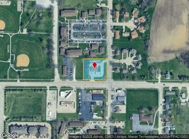
4402 W Locust St, Davenport, IA 52804
NEARBY LISTINGS FOR SALE OR LEASE
-
-
View all Davenport listings for lease on LoopNet.com
Property Detail
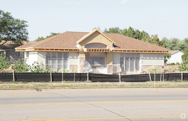
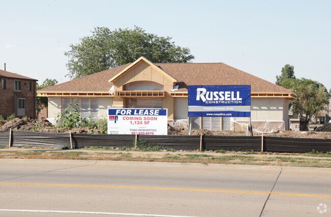
4402 W Locust St
T2053D01B
The Family Credit Union 1St Add
Financialbuilding
THE FAMILY CREDIT UNION 1ST ADD LOT: 001 THE FAMILY CREDITUNION 1ST ADDLOT 1
X
Scott
19163C0345H
Iowa
2025
1.02 AC
2025
Greater Davenport
012501
Davenport/Moline/Rock Island
2,006 SF
Davenport-Moline-Rock Island, IA-IL
DEMOGRAPHICS near 4402 W Locust St
1 Mile
3 Mile
5 Mile
2024 Total Population
6,683
43,768
104,378
2029 Population
6,604
43,382
103,951
Pop Growth 2024-2029
(1.18%)
(0.88%)
(0.41%)
Average Age
41
40
39
2024 Total Households
2,846
17,950
43,419
HH Growth 2024-2029
(1.26%)
(0.94%)
(0.40%)
Median Household Inc
$56,535
$53,817
$52,296
Avg Household Size
2.30
2.30
2.30
2024 Avg HH Vehicles
2.00
2.00
2.00
Median Home Value
$159,314
$133,264
$136,122
Median Year Built
1973
1959
1959
Nearby Places
Map Layers
Map Styles
 Street
 Aerial
- Restaurants
- Banks
- Shops
- Fitness
- Groceries
PUBLIC TRANSPORTATION
AIRPORT
Quad Cities International
DRIVE
WALK
Distance
Quad Cities International
24 min
16.3 mi
Freight Ports
Port Milwaukee
DRIVE
WALK
Distance
Port Milwaukee
248 min
217.2 mi
SALE & LEASE HISTORY
LISTING DATE
SALE/LEASE

Sep 25, 2016
For Lease
Nearby Properties
Address
Land Use
TOTAL SIZE
Lot Size
Zoning
Address
Land Use
TOTAL SIZE
Lot Size
Zoning
3,516 SF
26.74 AC
Address
Land Use
TOTAL SIZE
Lot Size
Zoning
63,359 SF
12.01 AC
Address
Land Use
TOTAL SIZE
Lot Size
Zoning
352,332 SF
34.16 AC
Address
Land Use
TOTAL SIZE
Lot Size
Zoning
77,187 SF
0.88 AC
Address
Land Use
TOTAL SIZE
Lot Size
Zoning
70,098 SF
9.72 AC
Address
Land Use
TOTAL SIZE
Lot Size
Zoning
86,976 SF
40 AC
Address
Land Use
TOTAL SIZE
Lot Size
Zoning
12,648 SF
8.28 AC
Address
Land Use
TOTAL SIZE
Lot Size
Zoning
213,686 SF
23.29 AC
Address
Land Use
TOTAL SIZE
Lot Size
Zoning
3,000 SF
59.92 AC
Address
Land Use
TOTAL SIZE
Lot Size
Zoning
54,026 SF
Address
Land Use
TOTAL SIZE
Lot Size
Zoning
70,974 SF
13.14 AC
Address
Land Use
TOTAL SIZE
Lot Size
Zoning
43,360 SF
2.92 AC
Address
Land Use
TOTAL SIZE
Lot Size
Zoning
25,803 SF
2 AC
Address
Land Use
TOTAL SIZE
Lot Size
Zoning
1,080 SF
16.40 AC
Address
Land Use
TOTAL SIZE
Lot Size
Zoning
12,969 SF
3.94 AC
Address
Land Use
TOTAL SIZE
Lot Size
Zoning
21,999 SF
22 AC
Address
Land Use
TOTAL SIZE
Lot Size
Zoning
77,870 SF
6.37 AC
Address
Land Use
TOTAL SIZE
Lot Size
Zoning
249,537 SF
44.45 AC
Address
Land Use
TOTAL SIZE
Lot Size
Zoning
329,938 SF
Address
Land Use
TOTAL SIZE
Lot Size
Zoning
10,758 SF
34.12 AC
Address
Land Use
TOTAL SIZE
Lot Size
Zoning
14,947 SF
26.21 AC
Address
Land Use
TOTAL SIZE
Lot Size
Zoning
4,000 SF
207.70 AC
Address
Land Use
TOTAL SIZE
Lot Size
Zoning
38,079 SF
5.09 AC
Address
Land Use
TOTAL SIZE
Lot Size
Zoning
408 SF
30.01 AC
Address
Land Use
TOTAL SIZE
Lot Size
Zoning
140,849 SF
39.23 AC
Address
Land Use
TOTAL SIZE
Lot Size
Zoning
109,871 SF
7.89 AC
Address
Land Use
TOTAL SIZE
Lot Size
Zoning
52,443 SF
11.48 AC
Address
Land Use
TOTAL SIZE
Lot Size
Zoning
224,549 SF
13.43 AC
Address
Land Use
TOTAL SIZE
Lot Size
Zoning
33,908 SF
8.91 AC
Address
Land Use
TOTAL SIZE
Lot Size
Zoning
2,105 SF
42.52 AC
The World's #1 Commercial Real Estate Marketplace
Connect with us
© 2025 CoStar Group
The information above has been obtained from sources believed reliable. While we do not doubt its accuracy we have not verified it and make no guarantee, warranty or representation about it. It is your responsibility to independently confirm its accuracy and completeness. Any projections, opinions, assumptions, or estimates used are for example only and do not represent the current or future performance of the property. The value of this transaction to you depends on tax and other factors which should be evaluated by your tax, financial, and legal advisors. You and your advisors should conduct a careful, independent investigation of the property to determine to your satisfaction the suitability of the property for your needs.