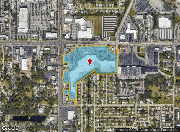
Property Record
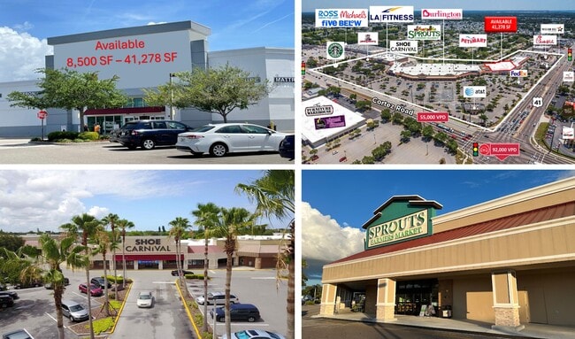
4403 14Th St W, Bradenton, FL 34207

NEARBY LISTINGS FOR SALE OR LEASE
Property Detail
4403 14Th St W
53598-0020-9
A TRACT OF LAND LYING IN THE NW 1/4 OF THE NE 1/4 OF SEC 11, TWN 35 S, RNG 17 E, MANATEE COUNTY, FLORIDA AND BEING MORE PARTICULARY DESC AS FOLLOWS: BEG AT THE SW COR OF
Regionalshoppingcenterormallwithanchorstore
Manatee
AE
Florida
12115C0050F
1
2024
21.60 AC
2025
Manatee
000201
Tampa/St Petersburg
397,863 SF
North Port-Bradenton-Sarasota, FL
DEMOGRAPHICS near 4403 14Th St W
1 mile
3 mile
5 mile
2024 Total Population
21,727
128,170
207,626
2029 Population
25,433
149,657
242,472
Pop Growth 2024-2029
+ 17.06%
+ 16.76%
+ 16.78%
Average Age
46
43
45
2024 Total Households
9,885
53,241
86,732
HH Growth 2024-2029
+ 16.20%
+ 16.14%
+ 16.06%
Median Household Inc
$36,156
$45,680
$51,249
Avg Household Size
2.10
2.30
2.30
2024 Avg HH Vehicles
1.00
2.00
2.00
Median Home Value
$72,253
$166,337
$223,012
Median Year Built
1974
1976
1979
Nearby Places
Map Layers
Map Styles
 Street
 Aerial
Transit
 Traffic
 Biking
Places
Listings with unknown addresses are not visible on the map
- Restaurants
- Banks
- Shops
- Fitness
- Groceries
PUBLIC TRANSPORTATION
AIRPORT
Sarasota/Bradenton International
Drive
Walk
Distance
Sarasota/Bradenton International
11 min
5.1 mi
Freight Ports
Port Manatee
Drive
Walk
Distance
Port Manatee
25 min
14.1 mi
SALE & LEASE HISTORY
LISTING DATE
SALE/LEASE

Sep 24, 2016
For Lease
Sep 22, 2025
For Lease
Sep 13, 2017
For Lease
May 08, 2025
For Lease
Jun 28, 2024
For Lease
Jun 07, 2018
For Sale
Jun 04, 2021
For Lease
Jul 23, 2024
For Lease
Aug 03, 2017
For Lease
Nearby Properties
Address
Land Use
TOTAL SIZE
Lot Size
Zoning
Address
Land Use
TOTAL SIZE
Lot Size
Zoning
623,436 SF
88.25 AC
PD-R,MP-I
Address
Land Use
TOTAL SIZE
Lot Size
Zoning
595,475 SF
16.90 AC
BR_T5
Address
Land Use
TOTAL SIZE
Lot Size
Zoning
349,711 SF
49.51 AC
BR_SD1
Address
Land Use
TOTAL SIZE
Lot Size
Zoning
437,460 SF
46.14 AC
PD-R
Address
Land Use
TOTAL SIZE
Lot Size
Zoning
405,843 SF
9.09 AC
BR_T5
Address
Land Use
TOTAL SIZE
Lot Size
Zoning
456,263 SF
28.02 AC
BR_R-3
Address
Land Use
TOTAL SIZE
Lot Size
Zoning
277,678 SF
7.80 AC
BR_T4-O, B
Address
Land Use
TOTAL SIZE
Lot Size
Zoning
314,018 SF
28.20 AC
BR_R-3
Address
Land Use
TOTAL SIZE
Lot Size
Zoning
645,805 SF
91.21 AC
PD-PI
Address
Land Use
TOTAL SIZE
Lot Size
Zoning
279,545 SF
19.41 AC
BR_R-1
Address
Land Use
TOTAL SIZE
Lot Size
Zoning
432,078 SF
1.64 AC
BR_T6
Address
Land Use
TOTAL SIZE
Lot Size
Zoning
318,507 SF
10.47 AC
BR_T4R,BR_
Address
Land Use
TOTAL SIZE
Lot Size
Zoning
2,401,721 SF
142.14 AC
PD-UI
Address
Land Use
TOTAL SIZE
Lot Size
Zoning
247,280 SF
17.72 AC
PD-R
Address
Land Use
TOTAL SIZE
Lot Size
Zoning
294,609 SF
19.15 AC
RMF9
Address
Land Use
TOTAL SIZE
Lot Size
Zoning
257,072 SF
10.07 AC
BR_T5
Address
Land Use
TOTAL SIZE
Lot Size
Zoning
117,547 SF
11.64 AC
MP-I
Address
Land Use
TOTAL SIZE
Lot Size
Zoning
153,663 SF
110.35 AC
MP-I
Address
Land Use
TOTAL SIZE
Lot Size
Zoning
375,171 SF
20 AC
PD-MU
Address
Land Use
TOTAL SIZE
Lot Size
Zoning
214,906 SF
20.71 AC
BR_R-1
Address
Land Use
TOTAL SIZE
Lot Size
Zoning
500,923 SF
47.91 AC
Address
Land Use
TOTAL SIZE
Lot Size
Zoning
223,974 SF
17.41 AC
BR_R-2
Address
Land Use
TOTAL SIZE
Lot Size
Zoning
541,781 SF
3.48 AC
BR_T5
Address
Land Use
TOTAL SIZE
Lot Size
Zoning
318,680 SF
1.31 AC
BR_FBC,BR_
Address
Land Use
TOTAL SIZE
Lot Size
Zoning
335,019 SF
32.58 AC
BR_R-3
Address
Land Use
TOTAL SIZE
Lot Size
Zoning
247,592 SF
13.39 AC
GC,RMF-6
Address
Land Use
TOTAL SIZE
Lot Size
Zoning
7,785 SF
75.25 AC
Address
Land Use
TOTAL SIZE
Lot Size
Zoning
7,772 SF
58.52 AC
RSMH-6
Address
Land Use
TOTAL SIZE
Lot Size
Zoning
198,036 SF
8.32 AC
GC GENERA
The World's #1 Commercial Real Estate Marketplace
Connect with us
© 2026 CoStar Group
The information above has been obtained from sources believed reliable. While we do not doubt its accuracy we have not verified it and make no guarantee, warranty or representation about it. It is your responsibility to independently confirm its accuracy and completeness. Any projections, opinions, assumptions, or estimates used are for example only and do not represent the current or future performance of the property. The value of this transaction to you depends on tax and other factors which should be evaluated by your tax, financial, and legal advisors. You and your advisors should conduct a careful, independent investigation of the property to determine to your satisfaction the suitability of the property for your needs.