Property Record
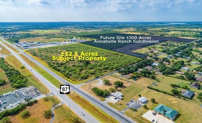
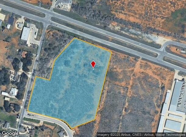
4403 E Us Highway 87 E, San Antonio, TX 78263
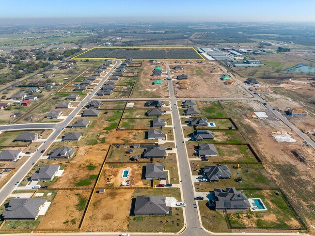
NEARBY LISTINGS FOR SALE OR LEASE
Property Detail
4403 E Us Highway 87 E
San Antonio-New Braunfels, TX
F Longuville Surv 4 Abs 423 C
05137-000-0493
CB 5137 P-49 ABS 423 2024 SPLIT PER DEED 20230195337// 2024-REMAINS PER SPLIT PER DEEDS 20230141054 (2.55 ACRES) OUT OF PID 334341. EXE 7-31-2023. VERIFY ALL IMPTS. SEE SURVEY MAP ATTACHED
Farms
Bexar
X
Texas
48029C0445H
49
2024
13.25 AC
2025
South
141900
San Antonio
DEMOGRAPHICS near 4403 E Us Highway 87 E
1 Mile
3 Mile
5 Mile
2024 Total Population
665
4,769
25,913
2029 Population
711
5,019
27,663
Pop Growth 2024-2029
+ 6.92%
+ 5.24%
+ 6.75%
Average Age
42
43
37
2024 Total Households
242
1,745
8,541
HH Growth 2024-2029
+ 7.02%
+ 5.39%
+ 6.85%
Median Household Inc
$47,954
$69,709
$68,344
Avg Household Size
2.70
2.70
3.00
2024 Avg HH Vehicles
3.00
3.00
2.00
Median Home Value
$248,125
$266,060
$195,477
Median Year Built
1983
1985
1998
Nearby Places
Map Layers
Map Styles
 Street
 Aerial
- Restaurants
- Banks
- Shops
- Fitness
- Groceries
PUBLIC TRANSPORTATION
AIRPORT
San Antonio International
DRIVE
WALK
Distance
San Antonio International
27 min
19.9 mi
Freight Ports
Calhoun Port
DRIVE
WALK
Distance
Calhoun Port
160 min
134.2 mi
SALE & LEASE HISTORY
LISTING DATE
SALE/LEASE

Sep 24, 2016
For Sale
Aug 30, 2019
For Sale
Nearby Properties
Address
Land Use
TOTAL SIZE
Lot Size
Zoning
Address
Land Use
TOTAL SIZE
Lot Size
Zoning
648 SF
392.83 AC
Address
Land Use
TOTAL SIZE
Lot Size
Zoning
3,131 SF
291.90 AC
Address
Land Use
TOTAL SIZE
Lot Size
Zoning
171,734 SF
40.14 AC
Address
Land Use
TOTAL SIZE
Lot Size
Zoning
1,368 SF
256.05 AC
Address
Land Use
TOTAL SIZE
Lot Size
Zoning
120,984 SF
5 AC
Address
Land Use
TOTAL SIZE
Lot Size
Zoning
61,636 SF
21.90 AC
Address
Land Use
TOTAL SIZE
Lot Size
Zoning
391,820 SF
19.13 AC
Address
Land Use
TOTAL SIZE
Lot Size
Zoning
Address
Land Use
TOTAL SIZE
Lot Size
Zoning
1,008 SF
192.31 AC
Address
Land Use
TOTAL SIZE
Lot Size
Zoning
78,479 SF
4.46 AC
Address
Land Use
TOTAL SIZE
Lot Size
Zoning
82,430 SF
107.10 AC
Address
Land Use
TOTAL SIZE
Lot Size
Zoning
84.86 AC
Address
Land Use
TOTAL SIZE
Lot Size
Zoning
39,892 SF
3 AC
Address
Land Use
TOTAL SIZE
Lot Size
Zoning
27,880 SF
7.38 AC
Address
Land Use
TOTAL SIZE
Lot Size
Zoning
16,695 SF
3 AC
Address
Land Use
TOTAL SIZE
Lot Size
Zoning
156.02 AC
Address
Land Use
TOTAL SIZE
Lot Size
Zoning
25,440 SF
2.51 AC
Address
Land Use
TOTAL SIZE
Lot Size
Zoning
145.12 AC
Address
Land Use
TOTAL SIZE
Lot Size
Zoning
24,100 SF
6.92 AC
Address
Land Use
TOTAL SIZE
Lot Size
Zoning
1,058 SF
134.62 AC
Address
Land Use
TOTAL SIZE
Lot Size
Zoning
2,706 SF
74.50 AC
Address
Land Use
TOTAL SIZE
Lot Size
Zoning
126.06 AC
Address
Land Use
TOTAL SIZE
Lot Size
Zoning
103.60 AC
Address
Land Use
TOTAL SIZE
Lot Size
Zoning
952 SF
79.04 AC
Address
Land Use
TOTAL SIZE
Lot Size
Zoning
5,910 SF
40.74 AC
Address
Land Use
TOTAL SIZE
Lot Size
Zoning
2,849 SF
107.47 AC
Address
Land Use
TOTAL SIZE
Lot Size
Zoning
11,020 SF
10 AC
Address
Land Use
TOTAL SIZE
Lot Size
Zoning
Address
Land Use
TOTAL SIZE
Lot Size
Zoning
976 SF
60.25 AC
Address
Land Use
TOTAL SIZE
Lot Size
Zoning
The World's #1 Commercial Real Estate Marketplace
Connect with us
© 2026 CoStar Group
The information above has been obtained from sources believed reliable. While we do not doubt its accuracy we have not verified it and make no guarantee, warranty or representation about it. It is your responsibility to independently confirm its accuracy and completeness. Any projections, opinions, assumptions, or estimates used are for example only and do not represent the current or future performance of the property. The value of this transaction to you depends on tax and other factors which should be evaluated by your tax, financial, and legal advisors. You and your advisors should conduct a careful, independent investigation of the property to determine to your satisfaction the suitability of the property for your needs.