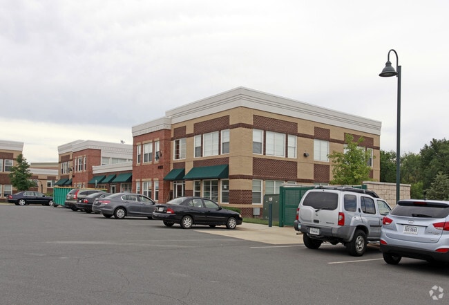
Property Record
44031 Pipeline Plz, Ashburn, VA 20147


Current Lease Availabilities
NEARBY LISTINGS FOR SALE OR LEASE
Property Detail
44031 Pipeline Plz
087-19-2862-001
Ashburn Crossroads Condo Ph.2
Commercialcondominium
ASHBURN CROSSROADS CONDO PH.2 UNIT 100 200606260055480 200603080021178P
X
Loudoun
51107C0263E
Virginia
2025
Route 28 Corridor North
2025
Washington, DC
611019
Washington-Arlington-Alexandria, DC-VA-MD-WV
2,580 SF
DEMOGRAPHICS near 44031 Pipeline Plz
1 Mile
3 Mile
5 Mile
2024 Total Population
12,332
92,897
200,435
2029 Population
13,419
100,689
216,564
Pop Growth 2024-2029
+ 8.81%
+ 8.39%
+ 8.05%
Average Age
36
38
37
2024 Total Households
3,866
32,611
68,251
HH Growth 2024-2029
+ 8.92%
+ 8.72%
+ 8.30%
Median Household Inc
$155,769
$154,964
$151,160
Avg Household Size
3.20
2.80
2.90
2024 Avg HH Vehicles
2.00
2.00
2.00
Median Home Value
$699,763
$688,511
$663,645
Median Year Built
1997
2003
2002
Nearby Places
Map Layers
Map Styles
 Street
 Aerial
- Restaurants
- Banks
- Shops
- Fitness
- Groceries
PUBLIC TRANSPORTATION
AIRPORT
Washington Dulles International
DRIVE
WALK
Distance
Washington Dulles International
17 min
7.9 mi
Ronald Reagan Washington Ntl
DRIVE
WALK
Distance
Ronald Reagan Washington Ntl
50 min
33.1 mi
Freight Ports
Port of Baltimore
DRIVE
WALK
Distance
Port of Baltimore
91 min
65.1 mi
Nearby Properties
Address
Land Use
TOTAL SIZE
Lot Size
Zoning
Address
Land Use
TOTAL SIZE
Lot Size
Zoning
2,735,138 SF
123.03 AC
PDAAAR
Address
Land Use
TOTAL SIZE
Lot Size
Zoning
431.05 AC
LB:PRC
Address
Land Use
TOTAL SIZE
Lot Size
Zoning
125.80 AC
TRC
Address
Land Use
TOTAL SIZE
Lot Size
Zoning
341,831 SF
31.21 AC
PDH6
Address
Land Use
TOTAL SIZE
Lot Size
Zoning
624,852 SF
22.54 AC
R24
Address
Land Use
TOTAL SIZE
Lot Size
Zoning
549,027 SF
21.01 AC
R16
Address
Land Use
TOTAL SIZE
Lot Size
Zoning
119,087 SF
339.95 AC
PDIP
Address
Land Use
TOTAL SIZE
Lot Size
Zoning
100,121 SF
2.20 AC
PDIP
Address
Land Use
TOTAL SIZE
Lot Size
Zoning
396,198 SF
5.84 AC
PDMUB
Address
Land Use
TOTAL SIZE
Lot Size
Zoning
264,155 SF
10.95 AC
PDTRC
Address
Land Use
TOTAL SIZE
Lot Size
Zoning
29,800 SF
43.29 AC
IP
Address
Land Use
TOTAL SIZE
Lot Size
Zoning
454,700 SF
54.92 AC
PDGI
Address
Land Use
TOTAL SIZE
Lot Size
Zoning
164,455 SF
14.15 AC
PDIP
Address
Land Use
TOTAL SIZE
Lot Size
Zoning
320,609 SF
2.02 AC
PDTRC
Address
Land Use
TOTAL SIZE
Lot Size
Zoning
198,672 SF
21.41 AC
R16
Address
Land Use
TOTAL SIZE
Lot Size
Zoning
287,479 SF
14.90 AC
PDAAAR
Address
Land Use
TOTAL SIZE
Lot Size
Zoning
152,394 SF
10.73 AC
PDIP
Address
Land Use
TOTAL SIZE
Lot Size
Zoning
308,805 SF
34.45 AC
PDCCRC
Address
Land Use
TOTAL SIZE
Lot Size
Zoning
61,692 SF
19.86 AC
PDH4
Address
Land Use
TOTAL SIZE
Lot Size
Zoning
218,277 SF
14.54 AC
PDH3
Address
Land Use
TOTAL SIZE
Lot Size
Zoning
260,741 SF
37.30 AC
PDH4
Address
Land Use
TOTAL SIZE
Lot Size
Zoning
1,026,767 SF
71 AC
PDSC
Address
Land Use
TOTAL SIZE
Lot Size
Zoning
238,594 SF
50.64 AC
PDGI
Address
Land Use
TOTAL SIZE
Lot Size
Zoning
29.72 AC
OP
Address
Land Use
TOTAL SIZE
Lot Size
Zoning
29.66 AC
OP
Address
Land Use
TOTAL SIZE
Lot Size
Zoning
204,320 SF
10.34 AC
PDRDP
Address
Land Use
TOTAL SIZE
Lot Size
Zoning
240,844 SF
12.11 AC
PDH4
Address
Land Use
TOTAL SIZE
Lot Size
Zoning
136.07 AC
PDGI
Address
Land Use
TOTAL SIZE
Lot Size
Zoning
290,695 SF
3.32 AC
PDOP
The World's #1 Commercial Real Estate Marketplace
Connect with us
© 2026 CoStar Group
The information above has been obtained from sources believed reliable. While we do not doubt its accuracy we have not verified it and make no guarantee, warranty or representation about it. It is your responsibility to independently confirm its accuracy and completeness. Any projections, opinions, assumptions, or estimates used are for example only and do not represent the current or future performance of the property. The value of this transaction to you depends on tax and other factors which should be evaluated by your tax, financial, and legal advisors. You and your advisors should conduct a careful, independent investigation of the property to determine to your satisfaction the suitability of the property for your needs.