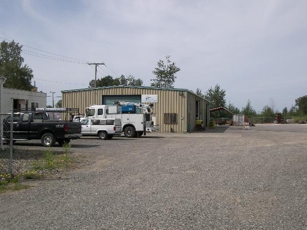
Property Record
4405 Curtis Rd, Bellingham, WA 98226

NEARBY LISTINGS FOR SALE OR LEASE
Property Detail
4405 Curtis Rd
380209-224424-0000
THAT PTN OF NE NW DAF-BEG AT NE COR OF NE NW-TH S ALG E LI THEREOF 814 FT TO SE COR OF TR CONV E O FOSSE UNDER AF 403936 SD PT BEING TPOB-TH W ALG S LI OF SD FOSSE TR 870 FT M/L TO E LI OF GREAT NORTHERN RR R/W-TH SLY ALG E LI OF SD RR R/W TO S LI OF
Lumberwoodproductmanufacturingincludingfurniture
Whatcom
X
Washington
53073C1190E
9.31 AC
2025
Bellingham/Northwest
2025
Other Market Areas
000201
Bellingham, WA
4,900 SF
DEMOGRAPHICS near 4405 Curtis Rd
1 Mile
3 Mile
5 Mile
2024 Total Population
738
14,503
54,330
2029 Population
767
15,250
56,790
Pop Growth 2024-2029
+ 3.93%
+ 5.15%
+ 4.53%
Average Age
41
40
40
2024 Total Households
263
6,143
22,449
HH Growth 2024-2029
+ 3.80%
+ 5.31%
+ 4.58%
Median Household Inc
$74,249
$57,450
$67,979
Avg Household Size
2.80
2.30
2.30
2024 Avg HH Vehicles
2.00
2.00
2.00
Median Home Value
$888,888
$484,801
$495,233
Median Year Built
2008
1995
1990
Nearby Places
Map Layers
Map Styles
 Street
 Aerial
- Restaurants
- Banks
- Shops
- Fitness
- Groceries
PUBLIC TRANSPORTATION
COMMUTER RAIL
DRIVE
WALK
Distance
19 min
8.8 mi
AIRPORT
Bellingham International
DRIVE
WALK
Distance
Bellingham International
8 min
3.4 mi
Abbotsford International
DRIVE
WALK
Distance
Abbotsford International
51 min
27.3 mi
Vancouver International
DRIVE
WALK
Distance
Vancouver International
66 min
45.8 mi
Freight Ports
Port of Bellingham, WA
DRIVE
WALK
Distance
Port of Bellingham, WA
14 min
6.4 mi
Nearby Properties
Address
Land Use
TOTAL SIZE
Lot Size
Zoning
Address
Land Use
TOTAL SIZE
Lot Size
Zoning
111,507 SF
845.26 AC
AO
Address
Land Use
TOTAL SIZE
Lot Size
Zoning
37,698 SF
8.43 AC
GB
Address
Land Use
TOTAL SIZE
Lot Size
Zoning
112,423 SF
3.23 AC
RS
Address
Land Use
TOTAL SIZE
Lot Size
Zoning
239,299 SF
7.73 AC
PRM2.5
Address
Land Use
TOTAL SIZE
Lot Size
Zoning
2,059 SF
8.02 AC
RM
Address
Land Use
TOTAL SIZE
Lot Size
Zoning
215,766 SF
6.09 AC
PRM2.5
Address
Land Use
TOTAL SIZE
Lot Size
Zoning
162,443 SF
8.01 AC
PI
Address
Land Use
TOTAL SIZE
Lot Size
Zoning
178,131 SF
7.42 AC
URM18
Address
Land Use
TOTAL SIZE
Lot Size
Zoning
168,279 SF
2.50 AC
PCM2.5
Address
Land Use
TOTAL SIZE
Lot Size
Zoning
166,448 SF
13.97 AC
PIC
Address
Land Use
TOTAL SIZE
Lot Size
Zoning
92,026 SF
3.58 AC
RCL72B
Address
Land Use
TOTAL SIZE
Lot Size
Zoning
149,046 SF
AO
Address
Land Use
TOTAL SIZE
Lot Size
Zoning
79,411 SF
5.26 AC
RCL72B
Address
Land Use
TOTAL SIZE
Lot Size
Zoning
83,022 SF
4.71 AC
URM18
Address
Land Use
TOTAL SIZE
Lot Size
Zoning
74,027 SF
3.54 AC
RO
Address
Land Use
TOTAL SIZE
Lot Size
Zoning
147,564 SF
7.63 AC
RPC
Address
Land Use
TOTAL SIZE
Lot Size
Zoning
128,509 SF
5.26 AC
RCI
Address
Land Use
TOTAL SIZE
Lot Size
Zoning
71,427 SF
3.22 AC
PIN
Address
Land Use
TOTAL SIZE
Lot Size
Zoning
57,757 SF
19.69 AC
RCL72B
Address
Land Use
TOTAL SIZE
Lot Size
Zoning
2,044 SF
6.63 AC
P
Address
Land Use
TOTAL SIZE
Lot Size
Zoning
64,509 SF
4.40 AC
GB
Address
Land Use
TOTAL SIZE
Lot Size
Zoning
156,099 SF
11.44 AC
GB
Address
Land Use
TOTAL SIZE
Lot Size
Zoning
300 SF
7.88 AC
LII
Address
Land Use
TOTAL SIZE
Lot Size
Zoning
57,900 SF
1.74 AC
PIC
Address
Land Use
TOTAL SIZE
Lot Size
Zoning
83,709 SF
7.01 AC
PRM2.5
Address
Land Use
TOTAL SIZE
Lot Size
Zoning
76,162 SF
5.78 AC
LII
Address
Land Use
TOTAL SIZE
Lot Size
Zoning
58,104 SF
2.93 AC
PCI
Address
Land Use
TOTAL SIZE
Lot Size
Zoning
87,834 SF
5.13 AC
RCI
Address
Land Use
TOTAL SIZE
Lot Size
Zoning
59,692 SF
1.80 AC
PIC
Address
Land Use
TOTAL SIZE
Lot Size
Zoning
54,772 SF
6.94 AC
LII
The World's #1 Commercial Real Estate Marketplace
Connect with us
© 2026 CoStar Group
The information above has been obtained from sources believed reliable. While we do not doubt its accuracy we have not verified it and make no guarantee, warranty or representation about it. It is your responsibility to independently confirm its accuracy and completeness. Any projections, opinions, assumptions, or estimates used are for example only and do not represent the current or future performance of the property. The value of this transaction to you depends on tax and other factors which should be evaluated by your tax, financial, and legal advisors. You and your advisors should conduct a careful, independent investigation of the property to determine to your satisfaction the suitability of the property for your needs.