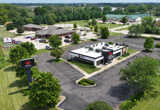
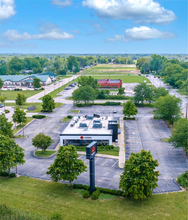
Property Record
4405 E Us Route 36, Decatur, IL 62521

Current Lease Availabilities
Property Detail
4405 E Us Route 36
Decatur, IL
EASTGATE PLAZA ~LT 1 ~04BK3546/624
09-13-20-452-009
Macon
Restaurantbuilding
Illinois
MUNICIPAL
1
B and X Area of moderate flood hazard, usually the area between the limits of the 100-year and 500-year floods.
1.85 AC
2024
Springfield/Decatur
2024
Other Market Areas
002402
NEARBY LISTINGS FOR SALE OR LEASE
DEMOGRAPHICS near 4405 E Us Route 36
1 mile
3 mile
5 mile
2025 Total Population
3,156
23,207
55,765
2030 Population
3,038
22,641
55,310
Pop Growth 2025-2030
(3.74%)
(2.44%)
(0.82%)
Average Age
47
43
40
2025 Total Households
1,414
10,169
23,771
HH Growth 2025-2030
(3.75%)
(2.57%)
(0.86%)
Median Household Inc
$78,719
$68,817
$53,334
Avg Household Size
2.10
2.20
2.20
2025 Avg HH Vehicles
2.00
2.00
2.00
Median Home Value
$137,359
$134,846
$102,130
Median Year Built
1966
1963
1960
Nearby Places
Map Layers
Map Styles
 Street
 Aerial
Layers
 Traffic
 Biking
Places
Listings with unknown addresses are not visible on the map
- Restaurants
- Banks
- Shops
- Fitness
- Groceries
Nearby Properties
Address
Land Use
TOTAL SIZE
Lot Size
Zoning
Address
Land Use
TOTAL SIZE
Lot Size
Zoning
87.31 AC
MUNICIPAL
Address
Land Use
TOTAL SIZE
Lot Size
Zoning
68.23 AC
MUNICIPAL
Address
Land Use
TOTAL SIZE
Lot Size
Zoning
23.63 AC
MUNICIPAL
Address
Land Use
TOTAL SIZE
Lot Size
Zoning
Address
Land Use
TOTAL SIZE
Lot Size
Zoning
25.59 AC
MUNICIPAL
Address
Land Use
TOTAL SIZE
Lot Size
Zoning
54.49 AC
MUNICIPAL
Address
Land Use
TOTAL SIZE
Lot Size
Zoning
Address
Land Use
TOTAL SIZE
Lot Size
Zoning
6.36 AC
MUNICIPAL
Address
Land Use
TOTAL SIZE
Lot Size
Zoning
2.61 AC
MUNICIPAL
Address
Land Use
TOTAL SIZE
Lot Size
Zoning
4.21 AC
MUNICIPAL
Address
Land Use
TOTAL SIZE
Lot Size
Zoning
21,555 SF
4.99 AC
MUNICIPAL
Address
Land Use
TOTAL SIZE
Lot Size
Zoning
1 AC
MUNICIPAL
Address
Land Use
TOTAL SIZE
Lot Size
Zoning
51.03 AC
MUNICIPAL
Address
Land Use
TOTAL SIZE
Lot Size
Zoning
4.64 AC
MUNICIPAL
Address
Land Use
TOTAL SIZE
Lot Size
Zoning
1.24 AC
MUNICIPAL
Address
Land Use
TOTAL SIZE
Lot Size
Zoning
6.20 AC
MUNICIPAL
Address
Land Use
TOTAL SIZE
Lot Size
Zoning
7.74 AC
MUNICIPAL
Address
Land Use
TOTAL SIZE
Lot Size
Zoning
4.05 AC
MUNICIPAL
Address
Land Use
TOTAL SIZE
Lot Size
Zoning
1.24 AC
MUNICIPAL
Address
Land Use
TOTAL SIZE
Lot Size
Zoning
6.28 AC
MUNICIPAL
Address
Land Use
TOTAL SIZE
Lot Size
Zoning
3.47 AC
MUNICIPAL
Address
Land Use
TOTAL SIZE
Lot Size
Zoning
8.22 AC
MUNICIPAL
Address
Land Use
TOTAL SIZE
Lot Size
Zoning
6.96 AC
MUNICIPAL
Address
Land Use
TOTAL SIZE
Lot Size
Zoning
2.89 AC
MUNICIPAL
Address
Land Use
TOTAL SIZE
Lot Size
Zoning
56.07 AC
MUNICIPAL
Address
Land Use
TOTAL SIZE
Lot Size
Zoning
2.21 AC
MUNICIPAL
Address
Land Use
TOTAL SIZE
Lot Size
Zoning
2.24 AC
MUNICIPAL
Address
Land Use
TOTAL SIZE
Lot Size
Zoning
1.67 AC
MUNICIPAL
Address
Land Use
TOTAL SIZE
Lot Size
Zoning
48.84 AC
MUNICIPAL
Address
Land Use
TOTAL SIZE
Lot Size
Zoning
0.85 AC
MUNICIPAL
The World's #1 Commercial Real Estate Marketplace
Connect with us
© 2026 CoStar Group
The information above has been obtained from sources believed reliable. While we do not doubt its accuracy we have not verified it and make no guarantee, warranty or representation about it. It is your responsibility to independently confirm its accuracy and completeness. Any projections, opinions, assumptions, or estimates used are for example only and do not represent the current or future performance of the property. The value of this transaction to you depends on tax and other factors which should be evaluated by your tax, financial, and legal advisors. You and your advisors should conduct a careful, independent investigation of the property to determine to your satisfaction the suitability of the property for your needs.