Property Record
4409 Hovis Rd, Charlotte, NC 28208
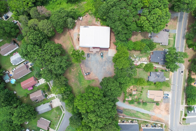
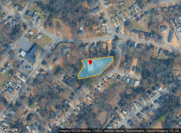
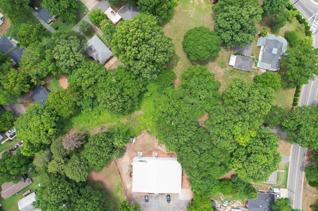
This Property Is For Sale
NEARBY LISTINGS FOR SALE OR LEASE
-
-
View all Charlotte listings for sale on LoopNet.com
Property Detail
4409 Hovis Rd
Charlotte-Concord-Gastonia, NC-SC
Thomasboro
063-072-16
Mecklenburg
Sfr
North Carolina
X
1.25 AC
3710453500K
Northwest Charlotte
8,920 SF
Charlotte
DEMOGRAPHICS near 4409 Hovis Rd
1 Mile
3 Mile
5 Mile
2024 Total Population
9,045
67,346
187,046
2029 Population
9,568
71,856
199,944
Pop Growth 2024-2029
+ 5.78%
+ 6.70%
+ 6.90%
Average Age
37
37
36
2024 Total Households
3,327
26,110
81,689
HH Growth 2024-2029
+ 5.80%
+ 6.98%
+ 7.19%
Median Household Inc
$39,843
$48,941
$62,437
Avg Household Size
2.60
2.50
2.20
2024 Avg HH Vehicles
2.00
2.00
2.00
Median Home Value
$131,227
$184,248
$240,866
Median Year Built
1965
1983
1999
Nearby Places
Map Layers
Map Styles
 Street
 Aerial
- Restaurants
- Banks
- Shops
- Fitness
- Groceries
PUBLIC TRANSPORTATION
COMMUTER RAIL
DRIVE
WALK
Distance
10 min
5.4 mi
AIRPORT
Charlotte/Douglas International
DRIVE
WALK
Distance
Charlotte/Douglas International
18 min
8.2 mi
Concord-Padgett Regional
DRIVE
WALK
Distance
Concord-Padgett Regional
25 min
16.6 mi
Nearby Properties
Address
Land Use
TOTAL SIZE
Lot Size
Zoning
Address
Land Use
TOTAL SIZE
Lot Size
Zoning
448,599 SF
3.16 AC
B1
Address
Land Use
TOTAL SIZE
Lot Size
Zoning
473,430 SF
3.35 AC
I1
Address
Land Use
TOTAL SIZE
Lot Size
Zoning
125,413 SF
15.50 AC
UR3
Address
Land Use
TOTAL SIZE
Lot Size
Zoning
415,899 SF
3.38 AC
UMUD
Address
Land Use
TOTAL SIZE
Lot Size
Zoning
320,495 SF
10.03 AC
MUDDO
Address
Land Use
TOTAL SIZE
Lot Size
Zoning
375,318 SF
37.31 AC
B2
Address
Land Use
TOTAL SIZE
Lot Size
Zoning
308,793 SF
47.41 AC
R5
Address
Land Use
TOTAL SIZE
Lot Size
Zoning
201,056 SF
5.76 AC
MUDDO
Address
Land Use
TOTAL SIZE
Lot Size
Zoning
311,541 SF
40.41 AC
INST
Address
Land Use
TOTAL SIZE
Lot Size
Zoning
162,354 SF
6.97 AC
I-2
Address
Land Use
TOTAL SIZE
Lot Size
Zoning
306,012 SF
4.28 AC
Address
Land Use
TOTAL SIZE
Lot Size
Zoning
58,666 SF
7.47 AC
Address
Land Use
TOTAL SIZE
Lot Size
Zoning
407,683 SF
37.23 AC
R22MF
Address
Land Use
TOTAL SIZE
Lot Size
Zoning
218,072 SF
1.94 AC
I2
Address
Land Use
TOTAL SIZE
Lot Size
Zoning
242,699 SF
20.50 AC
R17MF
Address
Land Use
TOTAL SIZE
Lot Size
Zoning
238,075 SF
9.52 AC
Address
Land Use
TOTAL SIZE
Lot Size
Zoning
536,042 SF
37.24 AC
R-22MF
Address
Land Use
TOTAL SIZE
Lot Size
Zoning
627,355 SF
45.41 AC
I2
Address
Land Use
TOTAL SIZE
Lot Size
Zoning
154,799 SF
6.09 AC
R12MF
Address
Land Use
TOTAL SIZE
Lot Size
Zoning
351,253 SF
27.85 AC
I-1(CD)
Address
Land Use
TOTAL SIZE
Lot Size
Zoning
170,968 SF
18.52 AC
I-2
Address
Land Use
TOTAL SIZE
Lot Size
Zoning
152,910 SF
2.98 AC
MUDD-O
Address
Land Use
TOTAL SIZE
Lot Size
Zoning
229,084 SF
11.04 AC
Address
Land Use
TOTAL SIZE
Lot Size
Zoning
227,235 SF
44 AC
R12MF
Address
Land Use
TOTAL SIZE
Lot Size
Zoning
25,095 SF
3.40 AC
MUDD-O
Address
Land Use
TOTAL SIZE
Lot Size
Zoning
174,768 SF
9.28 AC
INST(CD)
Address
Land Use
TOTAL SIZE
Lot Size
Zoning
135,614 SF
1.45 AC
R-5 (HD)
Address
Land Use
TOTAL SIZE
Lot Size
Zoning
205,067 SF
9.94 AC
R5
Address
Land Use
TOTAL SIZE
Lot Size
Zoning
103,323 SF
12.89 AC
R-8
Address
Land Use
TOTAL SIZE
Lot Size
Zoning
164,140 SF
11.81 AC
I-1
The World's #1 Commercial Real Estate Marketplace
Connect with us
© 2026 CoStar Group
The information above has been obtained from sources believed reliable. While we do not doubt its accuracy we have not verified it and make no guarantee, warranty or representation about it. It is your responsibility to independently confirm its accuracy and completeness. Any projections, opinions, assumptions, or estimates used are for example only and do not represent the current or future performance of the property. The value of this transaction to you depends on tax and other factors which should be evaluated by your tax, financial, and legal advisors. You and your advisors should conduct a careful, independent investigation of the property to determine to your satisfaction the suitability of the property for your needs.