Property Record
4409 N High St, Columbus, OH 43214
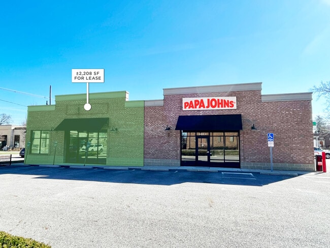
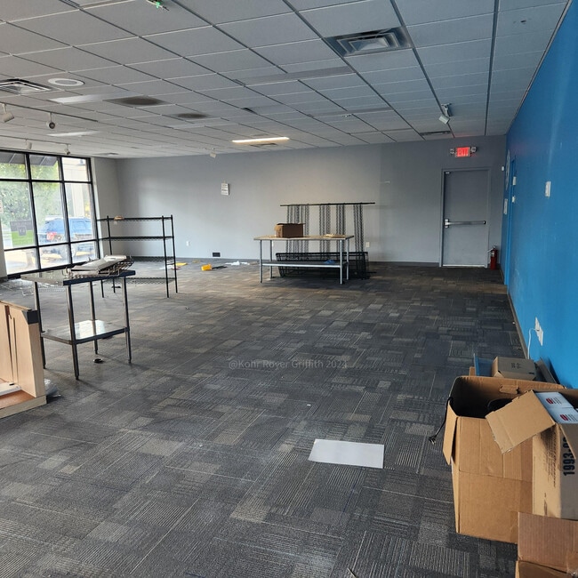

Current Lease Availabilities
NEARBY LISTINGS FOR SALE OR LEASE
Property Detail
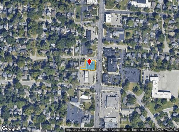
4409 N High St
Columbus, OH
Rosemary Addition
010-086629
ROSEMARY PT LOTS 4 & 5 EX IRR NE COR
Storebuilding
Franklin
X
Ohio
39049C0167K
4-5
2024
0.26 AC
2024
North Central
000120
Columbus
3,440 SF
DEMOGRAPHICS near 4409 N High St
1 Mile
3 Mile
5 Mile
2024 Total Population
11,086
124,999
366,656
2029 Population
11,030
124,714
366,569
Pop Growth 2024-2029
(0.51%)
(0.23%)
(0.02%)
Average Age
44
39
36
2024 Total Households
5,466
56,533
152,843
HH Growth 2024-2029
(0.49%)
(0.19%)
(0.04%)
Median Household Inc
$95,848
$65,382
$61,143
Avg Household Size
2.00
2.20
2.20
2024 Avg HH Vehicles
2.00
2.00
2.00
Median Home Value
$343,760
$285,809
$285,205
Median Year Built
1952
1962
1969
Nearby Places
- Restaurants
- Banks
- Shops
- Fitness
- Groceries
PUBLIC TRANSPORTATION
AIRPORT
John Glenn Columbus International
DRIVE
WALK
Distance
John Glenn Columbus International
16 min
12.1 mi
Freight Ports
Port of Baltimore
DRIVE
WALK
Distance
Port of Baltimore
1 min
345.9 mi
Nearby Properties
Address
Land Use
TOTAL SIZE
Lot Size
Zoning
Address
Land Use
TOTAL SIZE
Lot Size
Zoning
3,462,019 SF
54.42 AC
Address
Land Use
TOTAL SIZE
Lot Size
Zoning
344,620 SF
291.96 AC
Address
Land Use
TOTAL SIZE
Lot Size
Zoning
182,845 SF
325.61 AC
Address
Land Use
TOTAL SIZE
Lot Size
Zoning
378,522 SF
41.13 AC
Address
Land Use
TOTAL SIZE
Lot Size
Zoning
240,144 SF
45.78 AC
Address
Land Use
TOTAL SIZE
Lot Size
Zoning
10,368 SF
293.98 AC
Address
Land Use
TOTAL SIZE
Lot Size
Zoning
344,669 SF
8.45 AC
Address
Land Use
TOTAL SIZE
Lot Size
Zoning
517,875 SF
3.07 AC
Address
Land Use
TOTAL SIZE
Lot Size
Zoning
320,155 SF
84.68 AC
Address
Land Use
TOTAL SIZE
Lot Size
Zoning
234,504 SF
5.40 AC
Address
Land Use
TOTAL SIZE
Lot Size
Zoning
561,921 SF
6.81 AC
Address
Land Use
TOTAL SIZE
Lot Size
Zoning
265,341 SF
19.35 AC
Address
Land Use
TOTAL SIZE
Lot Size
Zoning
286,169 SF
11.08 AC
Address
Land Use
TOTAL SIZE
Lot Size
Zoning
438,301 SF
26.10 AC
Address
Land Use
TOTAL SIZE
Lot Size
Zoning
273,578 SF
0.94 AC
Address
Land Use
TOTAL SIZE
Lot Size
Zoning
425,872 SF
10.05 AC
Address
Land Use
TOTAL SIZE
Lot Size
Zoning
244,602 SF
27.30 AC
Address
Land Use
TOTAL SIZE
Lot Size
Zoning
Address
Land Use
TOTAL SIZE
Lot Size
Zoning
254,059 SF
6.94 AC
Address
Land Use
TOTAL SIZE
Lot Size
Zoning
397,193 SF
20.74 AC
Address
Land Use
TOTAL SIZE
Lot Size
Zoning
273,112 SF
13.97 AC
Address
Land Use
TOTAL SIZE
Lot Size
Zoning
162,408 SF
1.73 AC
Address
Land Use
TOTAL SIZE
Lot Size
Zoning
167,479 SF
36.79 AC
Address
Land Use
TOTAL SIZE
Lot Size
Zoning
171,832 SF
17.77 AC
Address
Land Use
TOTAL SIZE
Lot Size
Zoning
147,582 SF
5.75 AC
Address
Land Use
TOTAL SIZE
Lot Size
Zoning
170,237 SF
97.38 AC
Address
Land Use
TOTAL SIZE
Lot Size
Zoning
358,264 SF
10.88 AC
Address
Land Use
TOTAL SIZE
Lot Size
Zoning
157,919 SF
13.18 AC
Address
Land Use
TOTAL SIZE
Lot Size
Zoning
131,040 SF
2.50 AC
Address
Land Use
TOTAL SIZE
Lot Size
Zoning
150,468 SF
24.57 AC
The World's #1 Commercial Real Estate Marketplace
Connect with us
© 2025 CoStar Group
The information above has been obtained from sources believed reliable. While we do not doubt its accuracy we have not verified it and make no guarantee, warranty or representation about it. It is your responsibility to independently confirm its accuracy and completeness. Any projections, opinions, assumptions, or estimates used are for example only and do not represent the current or future performance of the property. The value of this transaction to you depends on tax and other factors which should be evaluated by your tax, financial, and legal advisors. You and your advisors should conduct a careful, independent investigation of the property to determine to your satisfaction the suitability of the property for your needs.