Property Record
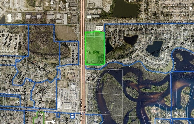
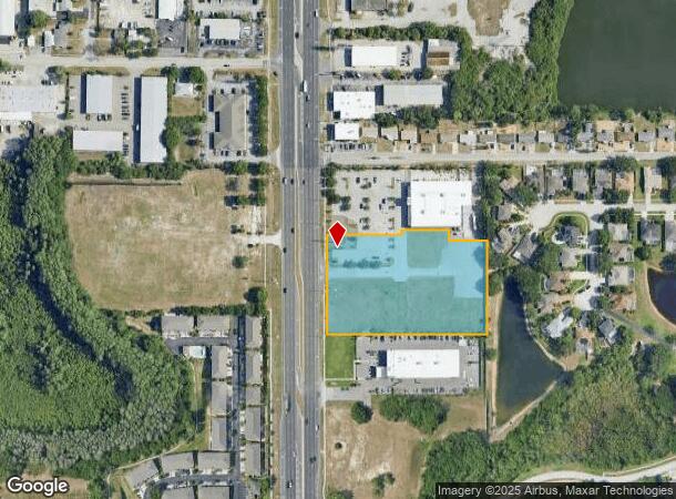
43899 Us Highway 19 N, Tarpon Springs, FL 34689
This Property Is For Sale
NEARBY LISTINGS FOR SALE OR LEASE
Property Detail
43899 Us Highway 19 N
Tampa-St. Petersburg-Clearwater, FL
Part Of Nw 1/4 Of Ne 1/4
06-27-16-00000-120-0300
PART OF NW 1/4 OF NE 1/4 OF SEC 06-27-16 DESC FROM NW COR OF NE 1/4 OF SD SEC TH S89D5813E 264.46 FT TH S00D0526E 207.85FT FOR POB TH S89D4517E 230.03FT TH N00D0709E 15.75FT TH S89D5902E 151 FT TH S00D0058W 34.68FT TH S89D5902E 118.92FT TH S00D0526W
Commercialacreage
Pinellas
X
Florida
12103C0036H
3.54 AC
2024
North Pinellas
2025
Tampa/St Petersburg
027308
DEMOGRAPHICS near 43899 Us Highway 19 N
1 Mile
3 Mile
5 Mile
2024 Total Population
9,382
73,033
150,759
2029 Population
10,770
84,143
172,334
Pop Growth 2024-2029
+ 14.79%
+ 15.21%
+ 14.31%
Average Age
43
44
45
2024 Total Households
4,039
31,461
65,073
HH Growth 2024-2029
+ 15.87%
+ 15.12%
+ 14.20%
Median Household Inc
$41,642
$45,783
$51,588
Avg Household Size
2.30
2.30
2.30
2024 Avg HH Vehicles
2.00
2.00
2.00
Median Home Value
$117,588
$172,979
$225,958
Median Year Built
1976
1977
1980
Nearby Places
- Restaurants
- Banks
- Shops
- Fitness
- Groceries
PUBLIC TRANSPORTATION
AIRPORT
Tampa International
DRIVE
WALK
Distance
Tampa International
42 min
24.6 mi
St Pete-Clearwater International
DRIVE
WALK
Distance
St Pete-Clearwater International
42 min
24.7 mi
Freight Ports
Port of Tampa Bay
DRIVE
WALK
Distance
Port of Tampa Bay
55 min
33.0 mi
Nearby Properties
Address
Land Use
TOTAL SIZE
Lot Size
Zoning
Address
Land Use
TOTAL SIZE
Lot Size
Zoning
214,040 SF
8.47 AC
Address
Land Use
TOTAL SIZE
Lot Size
Zoning
286,598 SF
6.56 AC
Address
Land Use
TOTAL SIZE
Lot Size
Zoning
314,948 SF
55.04 AC
MPUD
Address
Land Use
TOTAL SIZE
Lot Size
Zoning
202,954 SF
49.22 AC
AR
Address
Land Use
TOTAL SIZE
Lot Size
Zoning
333,044 SF
25.64 AC
R4
Address
Land Use
TOTAL SIZE
Lot Size
Zoning
154,033 SF
15.86 AC
Address
Land Use
TOTAL SIZE
Lot Size
Zoning
157,476 SF
27.47 AC
MPUD
Address
Land Use
TOTAL SIZE
Lot Size
Zoning
151,825 SF
18.01 AC
Address
Land Use
TOTAL SIZE
Lot Size
Zoning
145,216 SF
7.58 AC
MF3
Address
Land Use
TOTAL SIZE
Lot Size
Zoning
131,819 SF
11.24 AC
Address
Land Use
TOTAL SIZE
Lot Size
Zoning
81,053 SF
9.52 AC
Address
Land Use
TOTAL SIZE
Lot Size
Zoning
121,869 SF
4.72 AC
C2
Address
Land Use
TOTAL SIZE
Lot Size
Zoning
43,469 SF
11.48 AC
MPUD
Address
Land Use
TOTAL SIZE
Lot Size
Zoning
141,763 SF
12.96 AC
Address
Land Use
TOTAL SIZE
Lot Size
Zoning
81,045 SF
16.34 AC
PUD
Address
Land Use
TOTAL SIZE
Lot Size
Zoning
77,900 SF
10.52 AC
C2
Address
Land Use
TOTAL SIZE
Lot Size
Zoning
67,179 SF
9.52 AC
Address
Land Use
TOTAL SIZE
Lot Size
Zoning
80,212 SF
6.64 AC
Address
Land Use
TOTAL SIZE
Lot Size
Zoning
77,716 SF
2.54 AC
Address
Land Use
TOTAL SIZE
Lot Size
Zoning
203,135 SF
41.04 AC
C2
Address
Land Use
TOTAL SIZE
Lot Size
Zoning
143,430 SF
8.68 AC
Address
Land Use
TOTAL SIZE
Lot Size
Zoning
74,641 SF
9.20 AC
C2
Address
Land Use
TOTAL SIZE
Lot Size
Zoning
87,794 SF
7.97 AC
Address
Land Use
TOTAL SIZE
Lot Size
Zoning
70,901 SF
5.70 AC
Address
Land Use
TOTAL SIZE
Lot Size
Zoning
45,674 SF
4.21 AC
Address
Land Use
TOTAL SIZE
Lot Size
Zoning
44,321 SF
9.65 AC
Address
Land Use
TOTAL SIZE
Lot Size
Zoning
59,196 SF
4.41 AC
Address
Land Use
TOTAL SIZE
Lot Size
Zoning
77,384 SF
6.32 AC
Address
Land Use
TOTAL SIZE
Lot Size
Zoning
72,796 SF
2.62 AC
MF3
Address
Land Use
TOTAL SIZE
Lot Size
Zoning
65,939 SF
7.23 AC
C2
The World's #1 Commercial Real Estate Marketplace
Connect with us
© 2025 CoStar Group
The information above has been obtained from sources believed reliable. While we do not doubt its accuracy we have not verified it and make no guarantee, warranty or representation about it. It is your responsibility to independently confirm its accuracy and completeness. Any projections, opinions, assumptions, or estimates used are for example only and do not represent the current or future performance of the property. The value of this transaction to you depends on tax and other factors which should be evaluated by your tax, financial, and legal advisors. You and your advisors should conduct a careful, independent investigation of the property to determine to your satisfaction the suitability of the property for your needs.