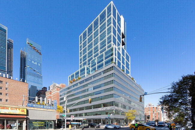
Property Record
441 9Th Ave, New York, NY 10001

NEARBY LISTINGS FOR SALE OR LEASE
Property Detail
441 9Th Ave
New York-Jersey City-White Plains, NY-NJ
Manhattan
0732-1001
New York
Officebuilding
1001
2024
0.91 AC
2025
Penn Plaza/Garment
011100
New York City
363,675 SF
DEMOGRAPHICS near 441 9Th Ave
1 Mile
3 Mile
5 Mile
2024 Total Population
144,670
1,258,479
2,530,908
2029 Population
134,073
1,179,605
2,388,151
Pop Growth 2024-2029
(7.32%)
(6.27%)
(5.64%)
Average Age
40
41
39
2024 Total Households
80,035
624,334
1,163,572
HH Growth 2024-2029
(7.51%)
(6.59%)
(6.01%)
Median Household Inc
$102,648
$106,980
$94,864
Avg Household Size
1.60
1.90
2.10
2024 Avg HH Vehicles
.00
.00
.00
Median Home Value
$917,761
$931,718
$879,787
Median Year Built
1969
1959
1958
Nearby Places
- Restaurants
- Banks
- Shops
- Fitness
- Groceries
PUBLIC TRANSPORTATION
TRANSIT/SUBWAY
34 Street-Penn Station (A,C,E Line) (A - New York MTA Subway (The Subway), C - New York MTA Subway (The Subway), E - New York MTA Subway (The Subway))
DRIVE
WALK
Distance
34 Street-Penn Station (A,C,E Line) (A - New York MTA Subway (The Subway), C - New York MTA Subway (The Subway), E - New York MTA Subway (The Subway))
0 min
3 min
0.2 mi
34 Street-Penn Station (1,2,3 Line) (1 - New York MTA Subway (The Subway), 2 - New York MTA Subway (The Subway), 3 - New York MTA Subway (The Subway))
DRIVE
WALK
Distance
34 Street-Penn Station (1,2,3 Line) (1 - New York MTA Subway (The Subway), 2 - New York MTA Subway (The Subway), 3 - New York MTA Subway (The Subway))
1 min
7 min
0.4 mi
34 St-Hudson Yards (7 - New York MTA Subway (The Subway))
DRIVE
WALK
Distance
34 St-Hudson Yards (7 - New York MTA Subway (The Subway))
1 min
8 min
0.4 mi
42 Street-Port Authority Bus Terminal (A - New York MTA Subway (The Subway), C - New York MTA Subway (The Subway), E - New York MTA Subway (The Subway))
DRIVE
WALK
Distance
42 Street-Port Authority Bus Terminal (A - New York MTA Subway (The Subway), C - New York MTA Subway (The Subway), E - New York MTA Subway (The Subway))
2 min
10 min
0.6 mi
28 Street (1,2 Line) (1 - New York MTA Subway (The Subway), 2 - New York MTA Subway (The Subway))
DRIVE
WALK
Distance
28 Street (1,2 Line) (1 - New York MTA Subway (The Subway), 2 - New York MTA Subway (The Subway))
2 min
12 min
0.7 mi
COMMUTER RAIL
Ny Moynihan Train Hall At Penn Station (Crescent - Amtrak, Ethan Allen Express - Amtrak, Keystone Service - Amtrak, Lake Shore Limited - Amtrak, Northeast Regional - Amtrak)
DRIVE
WALK
Distance
Ny Moynihan Train Hall At Penn Station (Crescent - Amtrak, Ethan Allen Express - Amtrak, Keystone Service - Amtrak, Lake Shore Limited - Amtrak, Northeast Regional - Amtrak)
2 min
6 min
0.4 mi
New York Penn Station (Njt) (Babylon Branch - Long Island Rail Road, Far Rockaway Branch - Long Island Rail Road, Hempstead Branch - Long Island Rail Road, Long Beach Branch - Long Island Rail Road, Montauk Branch - Long Island Rail Road, Montclair-Boonton Line - Long Island Rail Road, Morris & Essex Gladstone Branch - Long Island Rail Road, Morris & Essex Morristown Line - Long Island Rail Road, North Jersey Coast Line - Long Island Rail Road, Northeast Corridor Line - Long Island Rail Road, Port Jefferson Branch - Long Island Rail Road, Port Washington Branch - Long Island Rail Road, Ronkonkoma Branch - Long Island Rail Road, West Hempstead Branch - Long Island Rail Road)
DRIVE
WALK
Distance
New York Penn Station (Njt) (Babylon Branch - Long Island Rail Road, Far Rockaway Branch - Long Island Rail Road, Hempstead Branch - Long Island Rail Road, Long Beach Branch - Long Island Rail Road, Montauk Branch - Long Island Rail Road, Montclair-Boonton Line - Long Island Rail Road, Morris & Essex Gladstone Branch - Long Island Rail Road, Morris & Essex Morristown Line - Long Island Rail Road, North Jersey Coast Line - Long Island Rail Road, Northeast Corridor Line - Long Island Rail Road, Port Jefferson Branch - Long Island Rail Road, Port Washington Branch - Long Island Rail Road, Ronkonkoma Branch - Long Island Rail Road, West Hempstead Branch - Long Island Rail Road)
1 min
9 min
0.5 mi
AIRPORT
LaGuardia
DRIVE
WALK
Distance
LaGuardia
19 min
9.5 mi
Newark Liberty International
DRIVE
WALK
Distance
Newark Liberty International
18 min
13.8 mi
John F Kennedy International
DRIVE
WALK
Distance
John F Kennedy International
27 min
17.5 mi
Freight Ports
NY - Red Hook Container Terminal
DRIVE
WALK
Distance
NY - Red Hook Container Terminal
18 min
6.8 mi
SALE & LEASE HISTORY
LISTING DATE
SALE/LEASE

Sep 10, 2024
For Lease
Oct 10, 2022
For Lease
May 15, 2023
For Lease
Jun 15, 2023
For Lease
Jun 06, 2022
For Lease
Jul 16, 2024
For Lease
Jul 10, 2023
For Lease
Jan 08, 2025
For Lease
Jan 08, 2025
For Lease
Apr 21, 2025
For Lease
Nearby Properties
Address
Land Use
TOTAL SIZE
Lot Size
Zoning
Address
Land Use
TOTAL SIZE
Lot Size
Zoning
4,060,596 SF
22.09 AC
M2-3
Address
Land Use
TOTAL SIZE
Lot Size
Zoning
2,245,112 SF
2.02 AC
C6-6
Address
Land Use
TOTAL SIZE
Lot Size
Zoning
1,783,434 SF
1.94 AC
C5-3
Address
Land Use
TOTAL SIZE
Lot Size
Zoning
2,521,850 SF
1.59 AC
C6-4
Address
Land Use
TOTAL SIZE
Lot Size
Zoning
8,462,176 SF
61.41 AC
R7-2
Address
Land Use
TOTAL SIZE
Lot Size
Zoning
1,445,092 SF
3.10 AC
C6-4
Address
Land Use
TOTAL SIZE
Lot Size
Zoning
2,221,336 SF
1.55 AC
C6-4
Address
Land Use
TOTAL SIZE
Lot Size
Zoning
2,636,182 SF
2.35 AC
C65.5
Address
Land Use
TOTAL SIZE
Lot Size
Zoning
2,161,994 SF
3.79 AC
M1-5
Address
Land Use
TOTAL SIZE
Lot Size
Zoning
2,354,289 SF
3.96 AC
C6-4
Address
Land Use
TOTAL SIZE
Lot Size
Zoning
2,734,038 SF
4.24 AC
C52.5
Address
Land Use
TOTAL SIZE
Lot Size
Zoning
1,678,135 SF
1.01 AC
C5-3
Address
Land Use
TOTAL SIZE
Lot Size
Zoning
1,897,491 SF
2.06 AC
C52.5
Address
Land Use
TOTAL SIZE
Lot Size
Zoning
1,233,684 SF
16.94 AC
PARK
Address
Land Use
TOTAL SIZE
Lot Size
Zoning
1,638,259 SF
1.43 AC
C52.5
Address
Land Use
TOTAL SIZE
Lot Size
Zoning
2,360,627 SF
2.08 AC
C6-7
Address
Land Use
TOTAL SIZE
Lot Size
Zoning
1,642,675 SF
1.05 AC
C6-7
Address
Land Use
TOTAL SIZE
Lot Size
Zoning
1,984,228 SF
1.95 AC
C65.5
Address
Land Use
TOTAL SIZE
Lot Size
Zoning
1,048,620 SF
5.67 AC
C6-4
Address
Land Use
TOTAL SIZE
Lot Size
Zoning
1,586,876 SF
1.87 AC
C5-3
Address
Land Use
TOTAL SIZE
Lot Size
Zoning
1,962,900 SF
1.89 AC
C66.5
Address
Land Use
TOTAL SIZE
Lot Size
Zoning
1,946,157 SF
1.49 AC
C6-4
Address
Land Use
TOTAL SIZE
Lot Size
Zoning
1,842,991 SF
2.08 AC
C66.5
Address
Land Use
TOTAL SIZE
Lot Size
Zoning
2,535,958 SF
2.94 AC
C6-4
Address
Land Use
TOTAL SIZE
Lot Size
Zoning
1,178,640 SF
0.92 AC
C6-4
Address
Land Use
TOTAL SIZE
Lot Size
Zoning
1,751,641 SF
1.84 AC
C6-4
Address
Land Use
TOTAL SIZE
Lot Size
Zoning
6,877 SF
27.74 AC
UD
Address
Land Use
TOTAL SIZE
Lot Size
Zoning
1,613,847 SF
1.84 AC
C66.5
Address
Land Use
TOTAL SIZE
Lot Size
Zoning
1,596,521 SF
1.34 AC
C6-4
Address
Land Use
TOTAL SIZE
Lot Size
Zoning
2,344,406 SF
1.84 AC
C5-3
The World's #1 Commercial Real Estate Marketplace
Connect with us
© 2025 CoStar Group
The information above has been obtained from sources believed reliable. While we do not doubt its accuracy we have not verified it and make no guarantee, warranty or representation about it. It is your responsibility to independently confirm its accuracy and completeness. Any projections, opinions, assumptions, or estimates used are for example only and do not represent the current or future performance of the property. The value of this transaction to you depends on tax and other factors which should be evaluated by your tax, financial, and legal advisors. You and your advisors should conduct a careful, independent investigation of the property to determine to your satisfaction the suitability of the property for your needs.