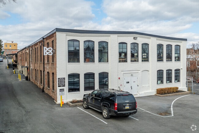
Property Record
425 E High St, Philadelphia, PA 19144
Current Lease Availabilities
NEARBY LISTINGS FOR SALE OR LEASE
Property Detail
425 E High St
Philadelphia-Camden-Wilmington, PA-NJ-DE-MD
Philadelphia
592043100
Pennsylvania
Duplex
0.15 AC
X
Northwest Philadelphia
42091C0395G
Philadelphia
1,800 SF
DEMOGRAPHICS near 425 E High St
1 Mile
3 Mile
5 Mile
2024 Total Population
44,141
305,895
714,182
2029 Population
43,017
296,800
700,317
Pop Growth 2024-2029
(2.55%)
(2.97%)
(1.94%)
Average Age
39
40
38
2024 Total Households
17,649
127,467
281,487
HH Growth 2024-2029
(3.05%)
(3.11%)
(2.03%)
Median Household Inc
$42,713
$51,595
$49,454
Avg Household Size
2.30
2.30
2.40
2024 Avg HH Vehicles
1.00
1.00
1.00
Median Home Value
$192,470
$196,322
$212,282
Median Year Built
1947
1948
1949
Nearby Places
Map Layers
Map Styles
 Street
 Aerial
- Restaurants
- Banks
- Shops
- Fitness
- Groceries
PUBLIC TRANSPORTATION
TRANSIT/SUBWAY
Washington Lane (R7 - Southeastern Pennsylvania Transportation Authority Regional Rail (SEPTA Regional Rail))
DRIVE
WALK
Distance
Washington Lane (R7 - Southeastern Pennsylvania Transportation Authority Regional Rail (SEPTA Regional Rail))
3 min
11 min
0.6 mi
Germantown (R7 - Southeastern Pennsylvania Transportation Authority Regional Rail (SEPTA Regional Rail))
DRIVE
WALK
Distance
Germantown (R7 - Southeastern Pennsylvania Transportation Authority Regional Rail (SEPTA Regional Rail))
3 min
13 min
0.7 mi
Wister (R7 - Southeastern Pennsylvania Transportation Authority Regional Rail (SEPTA Regional Rail))
DRIVE
WALK
Distance
Wister (R7 - Southeastern Pennsylvania Transportation Authority Regional Rail (SEPTA Regional Rail))
5 min
20 min
1.0 mi
COMMUTER RAIL
Washington Lane (R7 - Southeastern Pennsylvania Transportation Authority Regional Rail (SEPTA Regional Rail))
DRIVE
WALK
Distance
Washington Lane (R7 - Southeastern Pennsylvania Transportation Authority Regional Rail (SEPTA Regional Rail))
3 min
11 min
0.6 mi
Germantown (R7 - Southeastern Pennsylvania Transportation Authority Regional Rail (SEPTA Regional Rail))
DRIVE
WALK
Distance
Germantown (R7 - Southeastern Pennsylvania Transportation Authority Regional Rail (SEPTA Regional Rail))
3 min
13 min
0.6 mi
AIRPORT
Philadelphia International
DRIVE
WALK
Distance
Philadelphia International
35 min
18.0 mi
Trenton Mercer
DRIVE
WALK
Distance
Trenton Mercer
54 min
30.7 mi
Freight Ports
Port of Philadelphia
DRIVE
WALK
Distance
Port of Philadelphia
18 min
9.2 mi
Nearby Properties
Address
Land Use
TOTAL SIZE
Lot Size
Zoning
Address
Land Use
TOTAL SIZE
Lot Size
Zoning
638,776 SF
20 AC
RM2
Address
Land Use
TOTAL SIZE
Lot Size
Zoning
455,889 SF
33 AC
I2
Address
Land Use
TOTAL SIZE
Lot Size
Zoning
520,280 SF
14.84 AC
RM3
Address
Land Use
TOTAL SIZE
Lot Size
Zoning
2,146,150 SF
119.95 AC
M1
Address
Land Use
TOTAL SIZE
Lot Size
Zoning
22,648 SF
38.69 AC
RM3
Address
Land Use
TOTAL SIZE
Lot Size
Zoning
485,616 SF
8.96 AC
CMX3
Address
Land Use
TOTAL SIZE
Lot Size
Zoning
242,655 SF
3.29 AC
CMX3
Address
Land Use
TOTAL SIZE
Lot Size
Zoning
425,535 SF
4.60 AC
RM3
Address
Land Use
TOTAL SIZE
Lot Size
Zoning
121,578 SF
3.13 AC
RSA3
Address
Land Use
TOTAL SIZE
Lot Size
Zoning
587,330 SF
34.37 AC
SPINS
Address
Land Use
TOTAL SIZE
Lot Size
Zoning
287,286 SF
1.26 AC
CMX5
Address
Land Use
TOTAL SIZE
Lot Size
Zoning
17,886 SF
80 AC
SPPOA
Address
Land Use
TOTAL SIZE
Lot Size
Zoning
495,017 SF
9.65 AC
CMX3
Address
Land Use
TOTAL SIZE
Lot Size
Zoning
500,000 SF
2.30 AC
CMX3
Address
Land Use
TOTAL SIZE
Lot Size
Zoning
218,030 SF
23.75 AC
CA2
Address
Land Use
TOTAL SIZE
Lot Size
Zoning
180,750 SF
1.60 AC
CMX3
Address
Land Use
TOTAL SIZE
Lot Size
Zoning
568,410 SF
33.08 AC
RMX1
Address
Land Use
TOTAL SIZE
Lot Size
Zoning
293,734 SF
4.42 AC
ICMX
Address
Land Use
TOTAL SIZE
Lot Size
Zoning
237,834 SF
0.96 AC
CMX3
Address
Land Use
TOTAL SIZE
Lot Size
Zoning
211,200 SF
1.46 AC
CMX2
Address
Land Use
TOTAL SIZE
Lot Size
Zoning
300 AC
RSD1
Address
Land Use
TOTAL SIZE
Lot Size
Zoning
249,388 SF
8.08 AC
RSA5
Address
Land Use
TOTAL SIZE
Lot Size
Zoning
363,136 SF
16.47 AC
RSA3
Address
Land Use
TOTAL SIZE
Lot Size
Zoning
233,143 SF
24.24 AC
SPINS
Address
Land Use
TOTAL SIZE
Lot Size
Zoning
170,842 SF
16.51 AC
RSD1
Address
Land Use
TOTAL SIZE
Lot Size
Zoning
180,000 SF
13.30 AC
CMX3
Address
Land Use
TOTAL SIZE
Lot Size
Zoning
329,300 SF
6.98 AC
RSA5
Address
Land Use
TOTAL SIZE
Lot Size
Zoning
193,740 SF
4.96 AC
SPCIV
Address
Land Use
TOTAL SIZE
Lot Size
Zoning
336,613 SF
2.38 AC
R3
Address
Land Use
TOTAL SIZE
Lot Size
Zoning
281,012 SF
32.58 AC
RSA5
The World's #1 Commercial Real Estate Marketplace
Connect with us
© 2026 CoStar Group
The information above has been obtained from sources believed reliable. While we do not doubt its accuracy we have not verified it and make no guarantee, warranty or representation about it. It is your responsibility to independently confirm its accuracy and completeness. Any projections, opinions, assumptions, or estimates used are for example only and do not represent the current or future performance of the property. The value of this transaction to you depends on tax and other factors which should be evaluated by your tax, financial, and legal advisors. You and your advisors should conduct a careful, independent investigation of the property to determine to your satisfaction the suitability of the property for your needs.