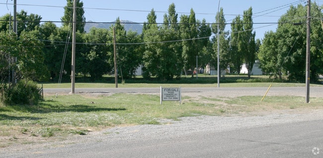
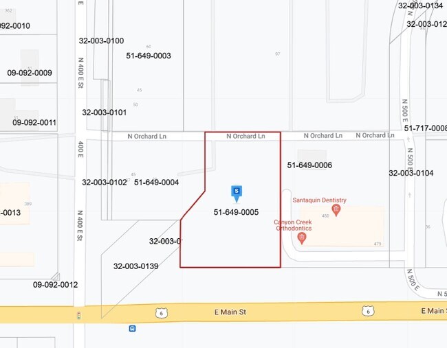
Property Record
441 E Main St, Santaquin, UT 84655

Property Detail
441 E Main St
Salt Lake City
LOT 5, RIDLEYS SUB AREA 0.785 AC.
Provo-Orem-Lehi, UT
UTAH
51-649-0005
Utah
Vacantlandnec
5
2024
0.79 AC
2025
Utah County
010505
NEARBY LISTINGS FOR SALE OR LEASE
DEMOGRAPHICS near 441 E Main St
1 mile
3 mile
5 mile
2025 Total Population
7,696
17,978
35,570
2030 Population
8,540
20,135
39,488
Pop Growth 2025-2030
+ 10.97%
+ 12.00%
+ 11.01%
Average Age
32
31
32
2025 Total Households
2,071
4,739
9,625
HH Growth 2025-2030
+ 11.54%
+ 12.64%
+ 11.67%
Median Household Inc
$93,859
$102,214
$99,736
Avg Household Size
3.60
3.80
3.70
2025 Avg HH Vehicles
3.00
3.00
3.00
Median Home Value
$459,200
$479,449
$482,997
Median Year Built
2001
2008
2004
Nearby Places
Map Layers
Map Styles
 Street
 Aerial
Transit
 Traffic
 Biking
Places
Listings with unknown addresses are not visible on the map
- Restaurants
- Banks
- Shops
- Fitness
- Groceries
PUBLIC TRANSPORTATION
AIRPORT
Provo Municipal
Drive
Walk
Distance
Provo Municipal
28 min
22.4 mi
Nearby Properties
Address
Land Use
TOTAL SIZE
Lot Size
Zoning
Address
Land Use
TOTAL SIZE
Lot Size
Zoning
59,366 SF
6.27 AC
Address
Land Use
TOTAL SIZE
Lot Size
Zoning
41,841 SF
7 AC
Address
Land Use
TOTAL SIZE
Lot Size
Zoning
90,402 SF
5.35 AC
Address
Land Use
TOTAL SIZE
Lot Size
Zoning
6.07 AC
Address
Land Use
TOTAL SIZE
Lot Size
Zoning
33,007 SF
0.93 AC
Address
Land Use
TOTAL SIZE
Lot Size
Zoning
141.78 AC
CE1
Address
Land Use
TOTAL SIZE
Lot Size
Zoning
39,620 SF
1.92 AC
Address
Land Use
TOTAL SIZE
Lot Size
Zoning
10,298 SF
3.16 AC
Address
Land Use
TOTAL SIZE
Lot Size
Zoning
5,252 SF
1.23 AC
Address
Land Use
TOTAL SIZE
Lot Size
Zoning
29,358 SF
8.90 AC
Address
Land Use
TOTAL SIZE
Lot Size
Zoning
111,209 SF
27.67 AC
Address
Land Use
TOTAL SIZE
Lot Size
Zoning
5.41 AC
Address
Land Use
TOTAL SIZE
Lot Size
Zoning
4.61 AC
Address
Land Use
TOTAL SIZE
Lot Size
Zoning
40,652 SF
2.83 AC
Address
Land Use
TOTAL SIZE
Lot Size
Zoning
8,489 SF
0.93 AC
Address
Land Use
TOTAL SIZE
Lot Size
Zoning
8,629 SF
0.99 AC
Address
Land Use
TOTAL SIZE
Lot Size
Zoning
12,254 SF
1.01 AC
Address
Land Use
TOTAL SIZE
Lot Size
Zoning
7,954 SF
0.94 AC
Address
Land Use
TOTAL SIZE
Lot Size
Zoning
6,339 SF
0.71 AC
Address
Land Use
TOTAL SIZE
Lot Size
Zoning
5,732 SF
0.94 AC
Address
Land Use
TOTAL SIZE
Lot Size
Zoning
3.30 AC
Address
Land Use
TOTAL SIZE
Lot Size
Zoning
3,415 SF
1.22 AC
Address
Land Use
TOTAL SIZE
Lot Size
Zoning
9,386 SF
1.54 AC
Address
Land Use
TOTAL SIZE
Lot Size
Zoning
4,192 SF
1.44 AC
The World's #1 Commercial Real Estate Marketplace
Connect with us
© 2026 CoStar Group
The information above has been obtained from sources believed reliable. While we do not doubt its accuracy we have not verified it and make no guarantee, warranty or representation about it. It is your responsibility to independently confirm its accuracy and completeness. Any projections, opinions, assumptions, or estimates used are for example only and do not represent the current or future performance of the property. The value of this transaction to you depends on tax and other factors which should be evaluated by your tax, financial, and legal advisors. You and your advisors should conduct a careful, independent investigation of the property to determine to your satisfaction the suitability of the property for your needs.