Property Record
441 Highway 79 S, Magnolia, AR 71753
NEARBY LISTINGS FOR SALE OR LEASE
-
-
View all Magnolia listings for sale on LoopNet.com
Property Detail
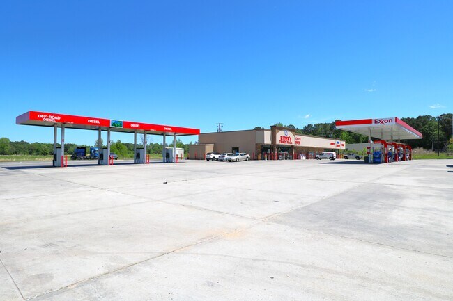
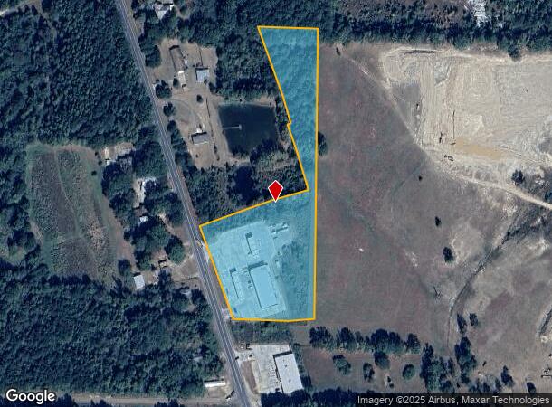
441 Highway 79 S
00-12886-00000
5.32AC SE NE BOOK 2025 PAGE 1572 441 HWY 79 PART OF THE SE1/4 NE1/4 OF SECTION 25, TOWNSHIP 17 SOUTH, RANGE 21 WEST, DESCRIBE
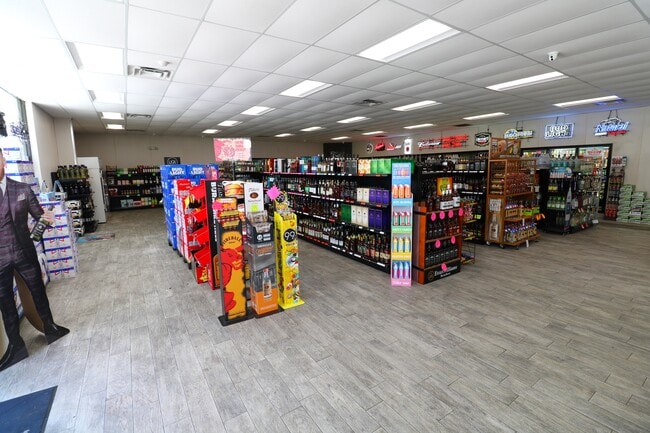
Conveniencestore
Columbia
X
Arkansas
05027C0325C
5.32 AC
2025
Arkansas South Area
2025
Other Market Areas
950302
Magnolia, AR
8,361 SF
DEMOGRAPHICS near 441 Highway 79 S
1 Mile
3 Mile
5 Mile
2024 Total Population
161
6,763
13,492
2029 Population
157
6,772
13,311
Pop Growth 2024-2029
(2.48%)
+ 0.13%
(1.34%)
Average Age
43
39
37
2024 Total Households
71
3,010
5,206
HH Growth 2024-2029
(2.82%)
+ 0.20%
(0.92%)
Median Household Inc
$45,625
$27,585
$36,666
Avg Household Size
2.20
2.20
2.20
2024 Avg HH Vehicles
2.00
2.00
2.00
Median Home Value
$157,894
$111,484
$136,558
Median Year Built
1983
1976
1973
Nearby Places
Map Layers
Map Styles
 Street
 Aerial
- Restaurants
- Banks
- Shops
- Fitness
- Groceries
SALE & LEASE HISTORY
LISTING DATE
SALE/LEASE

May 09, 2022
For Sale
Nearby Properties
Address
Land Use
TOTAL SIZE
Lot Size
Zoning
Address
Land Use
TOTAL SIZE
Lot Size
Zoning
37,516 SF
1.69 AC
Address
Land Use
TOTAL SIZE
Lot Size
Zoning
4,600 SF
10.50 AC
Address
Land Use
TOTAL SIZE
Lot Size
Zoning
109,820 SF
13.67 AC
Address
Land Use
TOTAL SIZE
Lot Size
Zoning
25,848 SF
0.57 AC
Address
Land Use
TOTAL SIZE
Lot Size
Zoning
33,104 SF
2 AC
Address
Land Use
TOTAL SIZE
Lot Size
Zoning
40,496 SF
Address
Land Use
TOTAL SIZE
Lot Size
Zoning
2,172 SF
6.36 AC
Address
Land Use
TOTAL SIZE
Lot Size
Zoning
65,394 SF
6.98 AC
Address
Land Use
TOTAL SIZE
Lot Size
Zoning
67,332 SF
3.45 AC
Address
Land Use
TOTAL SIZE
Lot Size
Zoning
74,783 SF
7.26 AC
Address
Land Use
TOTAL SIZE
Lot Size
Zoning
35,680 SF
2.82 AC
Address
Land Use
TOTAL SIZE
Lot Size
Zoning
14,429 SF
19.33 AC
Address
Land Use
TOTAL SIZE
Lot Size
Zoning
1,288 SF
9.25 AC
Address
Land Use
TOTAL SIZE
Lot Size
Zoning
80,892 SF
3.45 AC
Address
Land Use
TOTAL SIZE
Lot Size
Zoning
9,320 SF
7.08 AC
Address
Land Use
TOTAL SIZE
Lot Size
Zoning
55,580 SF
2.29 AC
Address
Land Use
TOTAL SIZE
Lot Size
Zoning
14,796 SF
0.82 AC
Address
Land Use
TOTAL SIZE
Lot Size
Zoning
14,980 SF
1.76 AC
Address
Land Use
TOTAL SIZE
Lot Size
Zoning
31,702 SF
1.55 AC
Address
Land Use
TOTAL SIZE
Lot Size
Zoning
35,292 SF
Address
Land Use
TOTAL SIZE
Lot Size
Zoning
5,870 SF
1.33 AC
Address
Land Use
TOTAL SIZE
Lot Size
Zoning
54,560 SF
7.89 AC
Address
Land Use
TOTAL SIZE
Lot Size
Zoning
16,442 SF
2.40 AC
Address
Land Use
TOTAL SIZE
Lot Size
Zoning
17,577 SF
2.20 AC
Address
Land Use
TOTAL SIZE
Lot Size
Zoning
37,741 SF
0.28 AC
Address
Land Use
TOTAL SIZE
Lot Size
Zoning
25,988 SF
1.71 AC
Address
Land Use
TOTAL SIZE
Lot Size
Zoning
14,440 SF
6.54 AC
Address
Land Use
TOTAL SIZE
Lot Size
Zoning
21,271 SF
24.43 AC
Address
Land Use
TOTAL SIZE
Lot Size
Zoning
6,786 SF
3.50 AC
The World's #1 Commercial Real Estate Marketplace
Connect with us
© 2025 CoStar Group
The information above has been obtained from sources believed reliable. While we do not doubt its accuracy we have not verified it and make no guarantee, warranty or representation about it. It is your responsibility to independently confirm its accuracy and completeness. Any projections, opinions, assumptions, or estimates used are for example only and do not represent the current or future performance of the property. The value of this transaction to you depends on tax and other factors which should be evaluated by your tax, financial, and legal advisors. You and your advisors should conduct a careful, independent investigation of the property to determine to your satisfaction the suitability of the property for your needs.