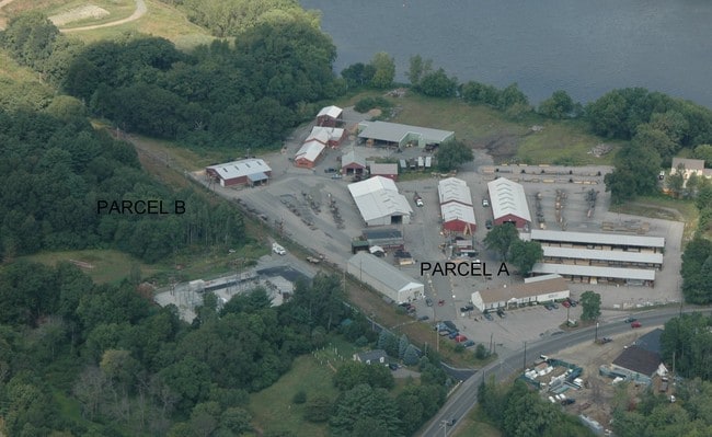
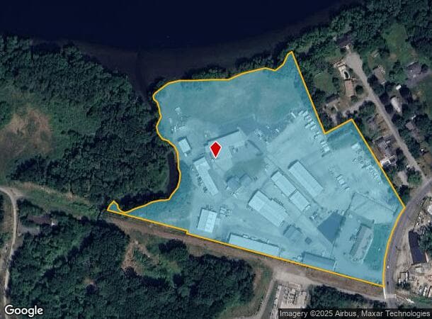
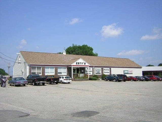
Property Record
441 Main St, Groveland, MA 01834
NEARBY LISTINGS FOR SALE OR LEASE
Property Detail
441 Main St
GROV-000024-000009
Essex
Commercialnec
Massachusetts
AE
13 AC
25009C0093G
Lawrence/Andover
2025
Boston
2025
Boston-Cambridge-Newton, MA-NH
264100
DEMOGRAPHICS near 441 Main St
1 Mile
3 Mile
5 Mile
2024 Total Population
4,719
42,223
90,010
2029 Population
4,679
41,707
89,139
Pop Growth 2024-2029
(0.85%)
(1.22%)
(0.97%)
Average Age
43
40
41
2024 Total Households
1,766
16,751
34,624
HH Growth 2024-2029
(1.02%)
(1.25%)
(1.07%)
Median Household Inc
$118,402
$76,913
$88,921
Avg Household Size
2.60
2.40
2.50
2024 Avg HH Vehicles
2.00
2.00
2.00
Median Home Value
$415,569
$419,706
$435,815
Median Year Built
1961
1954
1967
Nearby Places
Map Layers
Map Styles
 Street
 Aerial
- Restaurants
- Banks
- Shops
- Fitness
- Groceries
PUBLIC TRANSPORTATION
COMMUTER RAIL
Bradford (Haverhill Line - Massachusetts Bay Transportation Authority Commuter Rail (Purple Line))
DRIVE
WALK
Distance
Bradford (Haverhill Line - Massachusetts Bay Transportation Authority Commuter Rail (Purple Line))
8 min
3.7 mi
Haverhill (Haverhill Line - Massachusetts Bay Transportation Authority Commuter Rail (Purple Line))
DRIVE
WALK
Distance
Haverhill (Haverhill Line - Massachusetts Bay Transportation Authority Commuter Rail (Purple Line))
7 min
4.1 mi
AIRPORT
Portsmouth International at Pease
DRIVE
WALK
Distance
Portsmouth International at Pease
44 min
29.3 mi
General Edward Lawrence Logan International
DRIVE
WALK
Distance
General Edward Lawrence Logan International
52 min
32.9 mi
Manchester Boston Regional
DRIVE
WALK
Distance
Manchester Boston Regional
53 min
35.0 mi
Freight Ports
Port of Boston
DRIVE
WALK
Distance
Port of Boston
55 min
35.9 mi
SALE & LEASE HISTORY
LISTING DATE
SALE/LEASE

Sep 20, 2022
For Lease
Oct 10, 2019
For Lease
Jul 22, 2020
For Lease
Dec 27, 2016
For Lease
Nearby Properties
Address
Land Use
TOTAL SIZE
Lot Size
Zoning
Address
Land Use
TOTAL SIZE
Lot Size
Zoning
30.72 AC
Address
Land Use
TOTAL SIZE
Lot Size
Zoning
109.09 AC
Address
Land Use
TOTAL SIZE
Lot Size
Zoning
232,420 SF
4.58 AC
Address
Land Use
TOTAL SIZE
Lot Size
Zoning
38 AC
RB
Address
Land Use
TOTAL SIZE
Lot Size
Zoning
358,890 SF
5.72 AC
Address
Land Use
TOTAL SIZE
Lot Size
Zoning
225,253 SF
35.59 AC
RC
Address
Land Use
TOTAL SIZE
Lot Size
Zoning
226,309 SF
19.33 AC
R3
Address
Land Use
TOTAL SIZE
Lot Size
Zoning
187,600 SF
19.31 AC
Address
Land Use
TOTAL SIZE
Lot Size
Zoning
21.91 AC
Address
Land Use
TOTAL SIZE
Lot Size
Zoning
53.50 AC
C
Address
Land Use
TOTAL SIZE
Lot Size
Zoning
121,231 SF
1.11 AC
Address
Land Use
TOTAL SIZE
Lot Size
Zoning
200,081 SF
1.95 AC
Address
Land Use
TOTAL SIZE
Lot Size
Zoning
17.95 AC
Address
Land Use
TOTAL SIZE
Lot Size
Zoning
201,526 SF
24 AC
Address
Land Use
TOTAL SIZE
Lot Size
Zoning
92,931 SF
24.53 AC
RB
Address
Land Use
TOTAL SIZE
Lot Size
Zoning
159,058 SF
7.46 AC
Address
Land Use
TOTAL SIZE
Lot Size
Zoning
106,323 SF
2.05 AC
Address
Land Use
TOTAL SIZE
Lot Size
Zoning
69,094 SF
0.54 AC
Address
Land Use
TOTAL SIZE
Lot Size
Zoning
4,818 SF
12.90 AC
Address
Land Use
TOTAL SIZE
Lot Size
Zoning
88,943 SF
2.43 AC
Address
Land Use
TOTAL SIZE
Lot Size
Zoning
90,779 SF
1.74 AC
Address
Land Use
TOTAL SIZE
Lot Size
Zoning
16.87 AC
Address
Land Use
TOTAL SIZE
Lot Size
Zoning
90,836 SF
0.75 AC
Address
Land Use
TOTAL SIZE
Lot Size
Zoning
19.90 AC
RB
Address
Land Use
TOTAL SIZE
Lot Size
Zoning
79,928 SF
0.26 AC
Address
Land Use
TOTAL SIZE
Lot Size
Zoning
53,620 SF
14.40 AC
RB
Address
Land Use
TOTAL SIZE
Lot Size
Zoning
67,231 SF
1.44 AC
Address
Land Use
TOTAL SIZE
Lot Size
Zoning
113,181 SF
7 AC
Address
Land Use
TOTAL SIZE
Lot Size
Zoning
6.94 AC
Address
Land Use
TOTAL SIZE
Lot Size
Zoning
50,440 SF
0.27 AC
The World's #1 Commercial Real Estate Marketplace
Connect with us
© 2026 CoStar Group
The information above has been obtained from sources believed reliable. While we do not doubt its accuracy we have not verified it and make no guarantee, warranty or representation about it. It is your responsibility to independently confirm its accuracy and completeness. Any projections, opinions, assumptions, or estimates used are for example only and do not represent the current or future performance of the property. The value of this transaction to you depends on tax and other factors which should be evaluated by your tax, financial, and legal advisors. You and your advisors should conduct a careful, independent investigation of the property to determine to your satisfaction the suitability of the property for your needs.