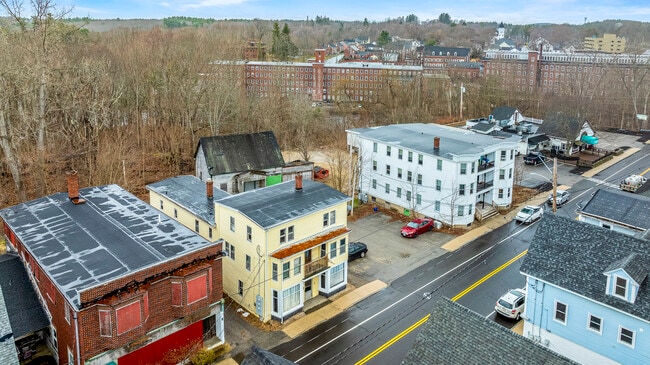
Property Record
441 Main St, South Berwick, ME 03908
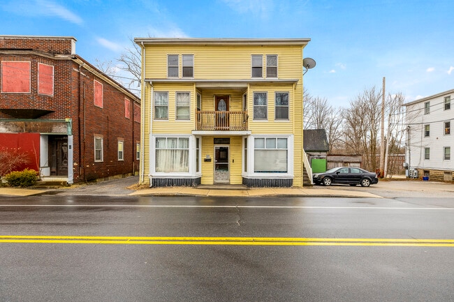
This Property Is For Sale
NEARBY LISTINGS FOR SALE OR LEASE
Property Detail
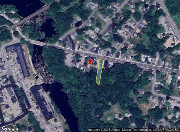
441 Main St
Portland-South Portland, ME
York
SBER-300160
Maine
Duplex
0.21 AC
A
York County
23031C0627G
Portland/South Portland
2,262 SF
DEMOGRAPHICS near 441 Main St
1 Mile
3 Mile
5 Mile
2024 Total Population
3,157
13,514
48,994
2029 Population
3,345
14,567
52,959
Pop Growth 2024-2029
+ 5.96%
+ 7.79%
+ 8.09%
Average Age
41
40
40
2024 Total Households
1,293
5,527
21,200
HH Growth 2024-2029
+ 6.03%
+ 7.98%
+ 8.48%
Median Household Inc
$75,151
$77,797
$90,595
Avg Household Size
2.40
2.40
2.30
2024 Avg HH Vehicles
2.00
2.00
2.00
Median Home Value
$298,047
$294,999
$330,580
Median Year Built
1955
1962
1971
Nearby Places
Map Layers
Map Styles
 Street
 Aerial
- Restaurants
- Banks
- Shops
- Fitness
- Groceries
PUBLIC TRANSPORTATION
COMMUTER RAIL
Dover (Downeaster - Amtrak)
DRIVE
WALK
Distance
Dover (Downeaster - Amtrak)
10 min
5.0 mi
AIRPORT
Portsmouth International at Pease
DRIVE
WALK
Distance
Portsmouth International at Pease
28 min
15.1 mi
Freight Ports
Portland, ME
DRIVE
WALK
Distance
Portland, ME
60 min
45.1 mi
Nearby Properties
Address
Land Use
TOTAL SIZE
Lot Size
Zoning
Address
Land Use
TOTAL SIZE
Lot Size
Zoning
672 SF
50.98 AC
I1 IND
Address
Land Use
TOTAL SIZE
Lot Size
Zoning
I1 IND
Address
Land Use
TOTAL SIZE
Lot Size
Zoning
I1 IND
Address
Land Use
TOTAL SIZE
Lot Size
Zoning
77,721 SF
22.63 AC
R1
Address
Land Use
TOTAL SIZE
Lot Size
Zoning
15,904 SF
54 AC
R1 RES
Address
Land Use
TOTAL SIZE
Lot Size
Zoning
178.76 AC
AI
Address
Land Use
TOTAL SIZE
Lot Size
Zoning
21.43 AC
I1 IND
Address
Land Use
TOTAL SIZE
Lot Size
Zoning
121,456 SF
25.46 AC
R1&R2
Address
Land Use
TOTAL SIZE
Lot Size
Zoning
19,032 SF
8.40 AC
B1 BUS
Address
Land Use
TOTAL SIZE
Lot Size
Zoning
6,800 SF
5.66 AC
R1 RES
Address
Land Use
TOTAL SIZE
Lot Size
Zoning
80,000 SF
12 AC
R1 RES
Address
Land Use
TOTAL SIZE
Lot Size
Zoning
4,704 SF
131.95 AC
R2 RES
Address
Land Use
TOTAL SIZE
Lot Size
Zoning
1.15 AC
R3
Address
Land Use
TOTAL SIZE
Lot Size
Zoning
58,860 SF
2.97 AC
B2 BUS
Address
Land Use
TOTAL SIZE
Lot Size
Zoning
61,128 SF
6.50 AC
I
Address
Land Use
TOTAL SIZE
Lot Size
Zoning
3.97 AC
R2A
Address
Land Use
TOTAL SIZE
Lot Size
Zoning
2.01 AC
R3
Address
Land Use
TOTAL SIZE
Lot Size
Zoning
7,500 SF
2.89 AC
R1 RES
Address
Land Use
TOTAL SIZE
Lot Size
Zoning
9.58 AC
MY
Address
Land Use
TOTAL SIZE
Lot Size
Zoning
0.32 AC
URBAN
Address
Land Use
TOTAL SIZE
Lot Size
Zoning
23,925 SF
2.97 AC
I1 IND
Address
Land Use
TOTAL SIZE
Lot Size
Zoning
31.93 AC
RC/I
Address
Land Use
TOTAL SIZE
Lot Size
Zoning
61,963 SF
7.30 AC
I
Address
Land Use
TOTAL SIZE
Lot Size
Zoning
11,817 SF
0.60 AC
B1 BUS
Address
Land Use
TOTAL SIZE
Lot Size
Zoning
23,427 SF
4 AC
URBAN
Address
Land Use
TOTAL SIZE
Lot Size
Zoning
16.60 AC
R1
Address
Land Use
TOTAL SIZE
Lot Size
Zoning
5.41 AC
CI
Address
Land Use
TOTAL SIZE
Lot Size
Zoning
15.90 AC
COUNTR
Address
Land Use
TOTAL SIZE
Lot Size
Zoning
16,380 SF
3.93 AC
B2 BUS
Address
Land Use
TOTAL SIZE
Lot Size
Zoning
105,554 SF
17.98 AC
SUBURB
The World's #1 Commercial Real Estate Marketplace
Connect with us
© 2026 CoStar Group
The information above has been obtained from sources believed reliable. While we do not doubt its accuracy we have not verified it and make no guarantee, warranty or representation about it. It is your responsibility to independently confirm its accuracy and completeness. Any projections, opinions, assumptions, or estimates used are for example only and do not represent the current or future performance of the property. The value of this transaction to you depends on tax and other factors which should be evaluated by your tax, financial, and legal advisors. You and your advisors should conduct a careful, independent investigation of the property to determine to your satisfaction the suitability of the property for your needs.