Property Record
441 N Buchanan Cir, Pacheco, CA 94553
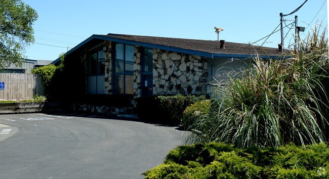


Property Detail
441 N Buchanan Cir
125-232-003-9
TRACT 2675 LOT 6
Industrialpark
CONTRA COSTA
CM
California
B and X Area of moderate flood hazard, usually the area between the limits of the 100-year and 500-year floods.
6
2025
4.13 AC
2025
Martinez/Pacheco/Hercules
321200
East Bay/Oakland
2,318 SF
Oakland-Fremont-Berkeley, CA
NEARBY LISTINGS FOR SALE OR LEASE
DEMOGRAPHICS near 441 N Buchanan Cir
1 mile
3 mile
5 mile
2025 Total Population
10,934
104,620
205,871
2030 Population
10,944
105,349
207,414
Pop Growth 2025-2030
+ 0.09%
+ 0.70%
+ 0.75%
Average Age
43
41
42
2025 Total Households
4,236
38,994
79,451
HH Growth 2025-2030
+ 0.14%
+ 0.72%
+ 0.83%
Median Household Inc
$121,465
$113,336
$119,755
Avg Household Size
2.50
2.60
2.50
2025 Avg HH Vehicles
2.00
2.00
2.00
Median Home Value
$691,183
$764,585
$805,619
Median Year Built
1980
1974
1971
Nearby Places
Map Layers
Map Styles
 Street
 Aerial
Transit
 Traffic
 Biking
Places
Listings with unknown addresses are not visible on the map
- Restaurants
- Banks
- Shops
- Fitness
- Groceries
PUBLIC TRANSPORTATION
COMMUTER RAIL
Martinez (California Zephyr - Capitol Corridor Joint Powers Authority, Capitol Corridor - Capitol Corridor Joint Powers Authority, Coast Starlight - Capitol Corridor Joint Powers Authority, San Joaquins - Capitol Corridor Joint Powers Authority)
Drive
Walk
Distance
Martinez (California Zephyr - Capitol Corridor Joint Powers Authority, Capitol Corridor - Capitol Corridor Joint Powers Authority, Coast Starlight - Capitol Corridor Joint Powers Authority, San Joaquins - Capitol Corridor Joint Powers Authority)
9 min
5.8 mi
AIRPORT
Metro Oakland International
Drive
Walk
Distance
Metro Oakland International
41 min
30.0 mi
Freight Ports
Port of Richmond
Drive
Walk
Distance
Port of Richmond
36 min
25.6 mi
Nearby Properties
Address
Land Use
TOTAL SIZE
Lot Size
Zoning
Address
Land Use
TOTAL SIZE
Lot Size
Zoning
562,584 SF
13.43 AC
Address
Land Use
TOTAL SIZE
Lot Size
Zoning
28,948 SF
63.56 AC
HI
Address
Land Use
TOTAL SIZE
Lot Size
Zoning
178.06 AC
HI
Address
Land Use
TOTAL SIZE
Lot Size
Zoning
489,813 SF
38.82 AC
Address
Land Use
TOTAL SIZE
Lot Size
Zoning
34,226 SF
30 AC
Address
Land Use
TOTAL SIZE
Lot Size
Zoning
25,089 SF
57.67 AC
HI
Address
Land Use
TOTAL SIZE
Lot Size
Zoning
12.82 AC
Address
Land Use
TOTAL SIZE
Lot Size
Zoning
66,196 SF
40.92 AC
HI
Address
Land Use
TOTAL SIZE
Lot Size
Zoning
31,614 SF
24.46 AC
Address
Land Use
TOTAL SIZE
Lot Size
Zoning
54,870 SF
34.53 AC
HI
Address
Land Use
TOTAL SIZE
Lot Size
Zoning
234,624 SF
6.63 AC
Address
Land Use
TOTAL SIZE
Lot Size
Zoning
70,000 SF
25.77 AC
Address
Land Use
TOTAL SIZE
Lot Size
Zoning
112,000 SF
18.40 AC
Address
Land Use
TOTAL SIZE
Lot Size
Zoning
168,606 SF
2.42 AC
Address
Land Use
TOTAL SIZE
Lot Size
Zoning
152,581 SF
1.39 AC
Address
Land Use
TOTAL SIZE
Lot Size
Zoning
301,628 SF
1.68 AC
Address
Land Use
TOTAL SIZE
Lot Size
Zoning
130,000 SF
2.62 AC
Address
Land Use
TOTAL SIZE
Lot Size
Zoning
9,840 SF
5.85 AC
Address
Land Use
TOTAL SIZE
Lot Size
Zoning
100,627 SF
6.47 AC
Address
Land Use
TOTAL SIZE
Lot Size
Zoning
59.41 AC
Address
Land Use
TOTAL SIZE
Lot Size
Zoning
45,744 SF
9.49 AC
Address
Land Use
TOTAL SIZE
Lot Size
Zoning
154,213 SF
1.74 AC
Address
Land Use
TOTAL SIZE
Lot Size
Zoning
109,000 SF
1.98 AC
Address
Land Use
TOTAL SIZE
Lot Size
Zoning
225,367 SF
7.42 AC
Address
Land Use
TOTAL SIZE
Lot Size
Zoning
86,074 SF
2.17 AC
Address
Land Use
TOTAL SIZE
Lot Size
Zoning
92,550 SF
3.88 AC
Address
Land Use
TOTAL SIZE
Lot Size
Zoning
3,036 SF
11.11 AC
Address
Land Use
TOTAL SIZE
Lot Size
Zoning
398.69 AC
HI
Address
Land Use
TOTAL SIZE
Lot Size
Zoning
196.06 AC
HI
Address
Land Use
TOTAL SIZE
Lot Size
Zoning
81,186 SF
0.55 AC
The World's #1 Commercial Real Estate Marketplace
Connect with us
© 2026 CoStar Group
The information above has been obtained from sources believed reliable. While we do not doubt its accuracy we have not verified it and make no guarantee, warranty or representation about it. It is your responsibility to independently confirm its accuracy and completeness. Any projections, opinions, assumptions, or estimates used are for example only and do not represent the current or future performance of the property. The value of this transaction to you depends on tax and other factors which should be evaluated by your tax, financial, and legal advisors. You and your advisors should conduct a careful, independent investigation of the property to determine to your satisfaction the suitability of the property for your needs.