Property Record
441 Patterson Blvd, Fairfield, OH 45014
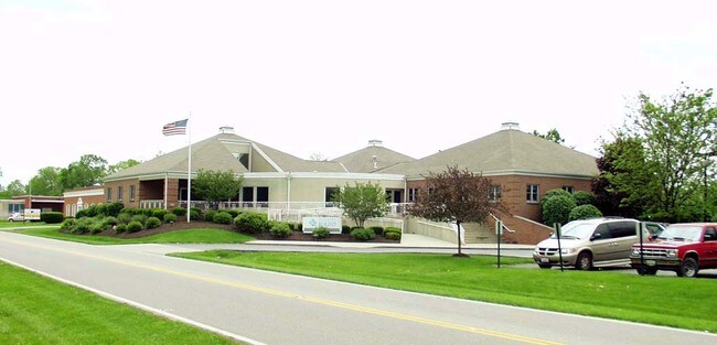

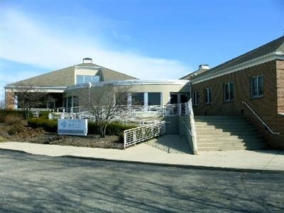

Property Detail
441 Patterson Blvd
Cincinnati, OH-KY-IN
198 CTR PT OF S 150
A0700-008-000-132
Butler
Commercialnec
Ohio
AE The base floodplain where base flood elevations are provided. AE Zones are now used on new format FIRMs instead of A1-A30 Zones.
198
2024
1.49 AC
2025
Butler County
010901
Cincinnati/Dayton
9,496 SF
NEARBY LISTINGS FOR SALE OR LEASE
DEMOGRAPHICS near 441 Patterson Blvd
1 mile
3 mile
5 mile
2025 Total Population
9,644
55,604
146,094
2030 Population
9,830
56,828
149,634
Pop Growth 2025-2030
+ 1.93%
+ 2.20%
+ 2.42%
Average Age
43
40
40
2025 Total Households
4,003
22,073
56,392
HH Growth 2025-2030
+ 1.95%
+ 2.22%
+ 2.56%
Median Household Inc
$71,125
$67,112
$67,011
Avg Household Size
2.40
2.50
2.50
2025 Avg HH Vehicles
2.00
2.00
2.00
Median Home Value
$232,439
$214,559
$212,544
Median Year Built
1970
1973
1972
Nearby Places
Map Layers
Map Styles
 Street
 Aerial
Layers
 Traffic
 Biking
Places
Listings with unknown addresses are not visible on the map
- Restaurants
- Banks
- Shops
- Fitness
- Groceries
PUBLIC TRANSPORTATION
AIRPORT
Cincinnati/Northern Kentucky International
Drive
Walk
Distance
Cincinnati/Northern Kentucky International
58 min
41.4 mi
Freight Ports
Port of Toledo
Drive
Walk
Distance
Port of Toledo
232 min
194.6 mi
Nearby Properties
Address
Land Use
TOTAL SIZE
Lot Size
Zoning
Address
Land Use
TOTAL SIZE
Lot Size
Zoning
40,006 SF
17.23 AC
Address
Land Use
TOTAL SIZE
Lot Size
Zoning
14,559 SF
27.50 AC
Address
Land Use
TOTAL SIZE
Lot Size
Zoning
52,548 SF
39.18 AC
Address
Land Use
TOTAL SIZE
Lot Size
Zoning
54.77 AC
Address
Land Use
TOTAL SIZE
Lot Size
Zoning
28.47 AC
Address
Land Use
TOTAL SIZE
Lot Size
Zoning
357,452 SF
26.77 AC
Address
Land Use
TOTAL SIZE
Lot Size
Zoning
28,343 SF
35.08 AC
Address
Land Use
TOTAL SIZE
Lot Size
Zoning
1,602,242 SF
53.34 AC
Address
Land Use
TOTAL SIZE
Lot Size
Zoning
183,864 SF
25.85 AC
Address
Land Use
TOTAL SIZE
Lot Size
Zoning
22.02 AC
Address
Land Use
TOTAL SIZE
Lot Size
Zoning
333,379 SF
22.22 AC
Address
Land Use
TOTAL SIZE
Lot Size
Zoning
143,569 SF
10.43 AC
Address
Land Use
TOTAL SIZE
Lot Size
Zoning
162,982 SF
16.96 AC
Address
Land Use
TOTAL SIZE
Lot Size
Zoning
174,444 SF
16.16 AC
Address
Land Use
TOTAL SIZE
Lot Size
Zoning
67,916 SF
13.73 AC
Address
Land Use
TOTAL SIZE
Lot Size
Zoning
144,922 SF
3.91 AC
Address
Land Use
TOTAL SIZE
Lot Size
Zoning
123,662 SF
2.86 AC
Address
Land Use
TOTAL SIZE
Lot Size
Zoning
11,316 SF
8.43 AC
RPUD
Address
Land Use
TOTAL SIZE
Lot Size
Zoning
89,401 SF
Address
Land Use
TOTAL SIZE
Lot Size
Zoning
27,504 SF
11.12 AC
Address
Land Use
TOTAL SIZE
Lot Size
Zoning
33.43 AC
Address
Land Use
TOTAL SIZE
Lot Size
Zoning
31.22 AC
Address
Land Use
TOTAL SIZE
Lot Size
Zoning
81,854 SF
7.69 AC
Address
Land Use
TOTAL SIZE
Lot Size
Zoning
29.96 AC
Address
Land Use
TOTAL SIZE
Lot Size
Zoning
Address
Land Use
TOTAL SIZE
Lot Size
Zoning
210,095 SF
32.35 AC
Address
Land Use
TOTAL SIZE
Lot Size
Zoning
1.29 AC
Address
Land Use
TOTAL SIZE
Lot Size
Zoning
93,740 SF
10.38 AC
Address
Land Use
TOTAL SIZE
Lot Size
Zoning
293,144 SF
22.02 AC
Address
Land Use
TOTAL SIZE
Lot Size
Zoning
152,636 SF
6.46 AC
The World's #1 Commercial Real Estate Marketplace
Connect with us
© 2026 CoStar Group
The information above has been obtained from sources believed reliable. While we do not doubt its accuracy we have not verified it and make no guarantee, warranty or representation about it. It is your responsibility to independently confirm its accuracy and completeness. Any projections, opinions, assumptions, or estimates used are for example only and do not represent the current or future performance of the property. The value of this transaction to you depends on tax and other factors which should be evaluated by your tax, financial, and legal advisors. You and your advisors should conduct a careful, independent investigation of the property to determine to your satisfaction the suitability of the property for your needs.