Property Record
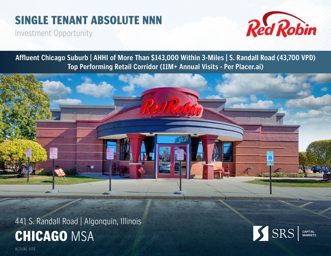
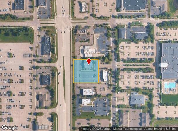
441 S Randall Rd, Algonquin, IL 60102
This Property Is For Sale
NEARBY LISTINGS FOR SALE OR LEASE
Property Detail
441 S Randall Rd
Chicago-Naperville-Elgin, IL-IN
Randall Rolls Second Resub
19-29-351-027
DOC 2011R0016168 LT 1 /EX DOC 2018R0009721/ RANDALL ROLLS SECOND RESUB
Commercialnec
McHenry
X
Illinois
17089C0065H
1
2024
1 AC
2024
Far Northwest
871206
Chicago
6,429 SF
DEMOGRAPHICS near 441 S Randall Rd
1 Mile
3 Mile
5 Mile
2024 Total Population
9,234
61,855
151,922
2029 Population
9,249
61,752
151,830
Pop Growth 2024-2029
+ 0.16%
(0.17%)
(0.06%)
Average Age
41
40
39
2024 Total Households
3,368
21,868
52,465
HH Growth 2024-2029
+ 0.15%
(0.15%)
(0.06%)
Median Household Inc
$92,911
$104,077
$100,777
Avg Household Size
2.70
2.80
2.80
2024 Avg HH Vehicles
2.00
2.00
2.00
Median Home Value
$273,005
$268,622
$262,753
Median Year Built
1995
1993
1992
Nearby Places
Map Layers
Map Styles
 Street
 Aerial
- Restaurants
- Banks
- Shops
- Fitness
- Groceries
PUBLIC TRANSPORTATION
COMMUTER RAIL
Crystal Lake Station (Union Pacific Northwest Line - Northeast Illinois Regional Commuter Railroad (Metra))
DRIVE
WALK
Distance
Crystal Lake Station (Union Pacific Northwest Line - Northeast Illinois Regional Commuter Railroad (Metra))
13 min
6.2 mi
Pingree Road Station (Union Pacific Northwest Line - Northeast Illinois Regional Commuter Railroad (Metra))
DRIVE
WALK
Distance
Pingree Road Station (Union Pacific Northwest Line - Northeast Illinois Regional Commuter Railroad (Metra))
14 min
6.5 mi
AIRPORT
Chicago O'Hare International
DRIVE
WALK
Distance
Chicago O'Hare International
45 min
34.6 mi
Nearby Properties
Address
Land Use
TOTAL SIZE
Lot Size
Zoning
Address
Land Use
TOTAL SIZE
Lot Size
Zoning
0.90 AC
Address
Land Use
TOTAL SIZE
Lot Size
Zoning
Address
Land Use
TOTAL SIZE
Lot Size
Zoning
Address
Land Use
TOTAL SIZE
Lot Size
Zoning
173,563 SF
0.48 AC
Address
Land Use
TOTAL SIZE
Lot Size
Zoning
54,472 SF
21 AC
Address
Land Use
TOTAL SIZE
Lot Size
Zoning
147,496 SF
11.81 AC
Address
Land Use
TOTAL SIZE
Lot Size
Zoning
Address
Land Use
TOTAL SIZE
Lot Size
Zoning
Address
Land Use
TOTAL SIZE
Lot Size
Zoning
11.91 AC
Address
Land Use
TOTAL SIZE
Lot Size
Zoning
28.69 AC
Address
Land Use
TOTAL SIZE
Lot Size
Zoning
195,564 SF
18.76 AC
Address
Land Use
TOTAL SIZE
Lot Size
Zoning
8.32 AC
Address
Land Use
TOTAL SIZE
Lot Size
Zoning
175,185 SF
13 AC
Address
Land Use
TOTAL SIZE
Lot Size
Zoning
Address
Land Use
TOTAL SIZE
Lot Size
Zoning
9,614 SF
1.42 AC
Address
Land Use
TOTAL SIZE
Lot Size
Zoning
106,309 SF
12.96 AC
Address
Land Use
TOTAL SIZE
Lot Size
Zoning
Address
Land Use
TOTAL SIZE
Lot Size
Zoning
85,319 SF
12.04 AC
Address
Land Use
TOTAL SIZE
Lot Size
Zoning
Address
Land Use
TOTAL SIZE
Lot Size
Zoning
Address
Land Use
TOTAL SIZE
Lot Size
Zoning
7.95 AC
Address
Land Use
TOTAL SIZE
Lot Size
Zoning
134,523 SF
15.27 AC
Address
Land Use
TOTAL SIZE
Lot Size
Zoning
81,873 SF
9.38 AC
Address
Land Use
TOTAL SIZE
Lot Size
Zoning
Address
Land Use
TOTAL SIZE
Lot Size
Zoning
Address
Land Use
TOTAL SIZE
Lot Size
Zoning
94,825 SF
0.50 AC
Address
Land Use
TOTAL SIZE
Lot Size
Zoning
55,183 SF
4.34 AC
Address
Land Use
TOTAL SIZE
Lot Size
Zoning
The World's #1 Commercial Real Estate Marketplace
Connect with us
© 2026 CoStar Group
The information above has been obtained from sources believed reliable. While we do not doubt its accuracy we have not verified it and make no guarantee, warranty or representation about it. It is your responsibility to independently confirm its accuracy and completeness. Any projections, opinions, assumptions, or estimates used are for example only and do not represent the current or future performance of the property. The value of this transaction to you depends on tax and other factors which should be evaluated by your tax, financial, and legal advisors. You and your advisors should conduct a careful, independent investigation of the property to determine to your satisfaction the suitability of the property for your needs.