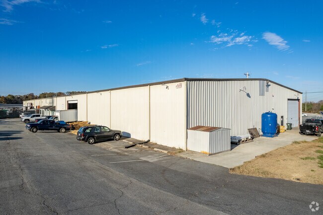
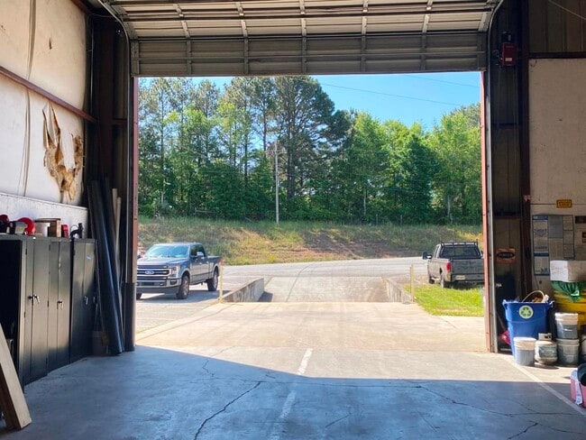
Property Record
441 Satellite Blvd Ne, Suwanee, GA 30024

Property Detail
441 Satellite Blvd Ne
7-171-030
TRACT 2 SATELLITE BLVD
Warehouse
GWINNETT
M1
Georgia
B and X Area of moderate flood hazard, usually the area between the limits of the 100-year and 500-year floods.
2.22 AC
2025
Duluth/Suwanee/Buford
2025
Atlanta
050243
Atlanta-Sandy Springs-Roswell, GA
41,400 SF
NEARBY LISTINGS FOR SALE OR LEASE
DEMOGRAPHICS near 441 Satellite Blvd Ne
1 mile
3 mile
5 mile
2025 Total Population
4,112
64,588
184,562
2030 Population
4,267
67,841
193,887
Pop Growth 2025-2030
+ 3.77%
+ 5.04%
+ 5.05%
Average Age
39
39
39
2025 Total Households
1,249
21,992
61,828
HH Growth 2025-2030
+ 3.84%
+ 5.31%
+ 5.24%
Median Household Inc
$122,738
$101,744
$101,759
Avg Household Size
3.20
2.90
2.90
2025 Avg HH Vehicles
3.00
2.00
2.00
Median Home Value
$443,619
$434,534
$441,550
Median Year Built
1996
1998
1998
Nearby Places
Map Layers
Map Styles
 Street
 Aerial
Transit
 Traffic
 Biking
Places
Listings with unknown addresses are not visible on the map
- Restaurants
- Banks
- Shops
- Fitness
- Groceries
SALE & LEASE HISTORY
LISTING DATE
SALE/LEASE

Jun 06, 2022
For Sale
Nearby Properties
Address
Land Use
TOTAL SIZE
Lot Size
Zoning
Address
Land Use
TOTAL SIZE
Lot Size
Zoning
563,718 SF
41.75 AC
RM13
Address
Land Use
TOTAL SIZE
Lot Size
Zoning
534,578 SF
44.21 AC
RM8
Address
Land Use
TOTAL SIZE
Lot Size
Zoning
393,939 SF
42.21 AC
RM8
Address
Land Use
TOTAL SIZE
Lot Size
Zoning
419,467 SF
665.75 AC
RZT
Address
Land Use
TOTAL SIZE
Lot Size
Zoning
455,605 SF
33.93 AC
RM13
Address
Land Use
TOTAL SIZE
Lot Size
Zoning
415,963 SF
48.86 AC
RM10
Address
Land Use
TOTAL SIZE
Lot Size
Zoning
461,593 SF
14.11 AC
MUR
Address
Land Use
TOTAL SIZE
Lot Size
Zoning
330,562 SF
29.62 AC
RM13
Address
Land Use
TOTAL SIZE
Lot Size
Zoning
379,183 SF
6.09 AC
PMUD
Address
Land Use
TOTAL SIZE
Lot Size
Zoning
415,609 SF
16.50 AC
RM24
Address
Land Use
TOTAL SIZE
Lot Size
Zoning
367,419 SF
17.06 AC
RM24
Address
Land Use
TOTAL SIZE
Lot Size
Zoning
439,723 SF
64.56 AC
R100
Address
Land Use
TOTAL SIZE
Lot Size
Zoning
428,329 SF
18.44 AC
RM24
Address
Land Use
TOTAL SIZE
Lot Size
Zoning
282,431 SF
23.20 AC
RM13
Address
Land Use
TOTAL SIZE
Lot Size
Zoning
282,630 SF
11.83 AC
MUO
Address
Land Use
TOTAL SIZE
Lot Size
Zoning
234,420 SF
10.35 AC
PMUD
Address
Land Use
TOTAL SIZE
Lot Size
Zoning
220,779 SF
7.32 AC
PMUD
Address
Land Use
TOTAL SIZE
Lot Size
Zoning
514,956 SF
47.21 AC
M1
Address
Land Use
TOTAL SIZE
Lot Size
Zoning
313,869 SF
12.19 AC
RM24
Address
Land Use
TOTAL SIZE
Lot Size
Zoning
240,556 SF
49.13 AC
HM1
Address
Land Use
TOTAL SIZE
Lot Size
Zoning
385,167 SF
49.55 AC
M1
Address
Land Use
TOTAL SIZE
Lot Size
Zoning
332,011 SF
8.84 AC
PMUD
Address
Land Use
TOTAL SIZE
Lot Size
Zoning
102,152 SF
20.95 AC
C2
Address
Land Use
TOTAL SIZE
Lot Size
Zoning
218,583 SF
2.21 AC
MUO
Address
Land Use
TOTAL SIZE
Lot Size
Zoning
6,552 SF
235.95 AC
R140
Address
Land Use
TOTAL SIZE
Lot Size
Zoning
223,096 SF
6.06 AC
MUR
Address
Land Use
TOTAL SIZE
Lot Size
Zoning
661,663 SF
50.64 AC
M1
Address
Land Use
TOTAL SIZE
Lot Size
Zoning
379,104 SF
20 AC
OI
Address
Land Use
TOTAL SIZE
Lot Size
Zoning
327,360 SF
26.42 AC
M1
Address
Land Use
TOTAL SIZE
Lot Size
Zoning
457,110 SF
22.37 AC
M1
The World's #1 Commercial Real Estate Marketplace
Connect with us
© 2026 CoStar Group
The information above has been obtained from sources believed reliable. While we do not doubt its accuracy we have not verified it and make no guarantee, warranty or representation about it. It is your responsibility to independently confirm its accuracy and completeness. Any projections, opinions, assumptions, or estimates used are for example only and do not represent the current or future performance of the property. The value of this transaction to you depends on tax and other factors which should be evaluated by your tax, financial, and legal advisors. You and your advisors should conduct a careful, independent investigation of the property to determine to your satisfaction the suitability of the property for your needs.