Property Record
441 W Broad St, Pataskala, OH 43062
NEARBY LISTINGS FOR SALE OR LEASE
-
-
View all Pataskala listings for sale on LoopNet.com
Property Detail
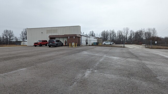
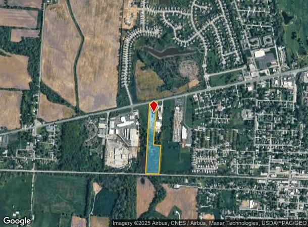
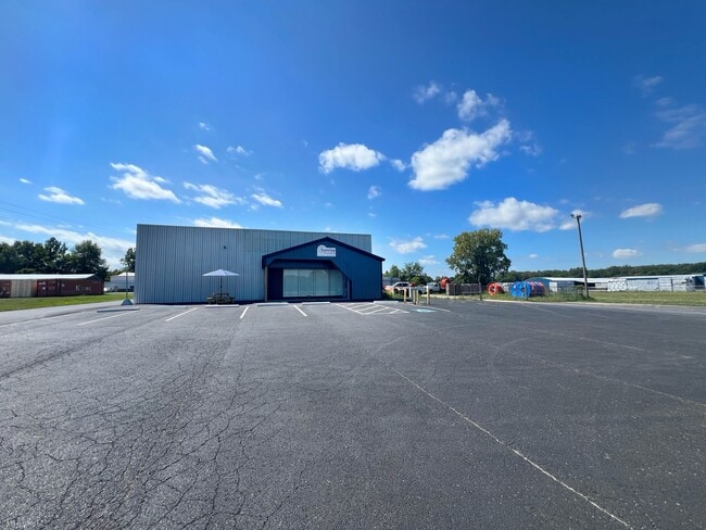
441 W Broad St
Columbus, OH
Old Pataskala Village
063-312312-01.000
8.93 AC LOT 12 R15 T1 Q4
Utilities
Licking
X
Ohio
39089C0293J
12
0
8.93 AC
2024
Licking County
756500
Columbus
6,180 SF
DEMOGRAPHICS near 441 W Broad St
1 Mile
3 Mile
5 Mile
2024 Total Population
5,291
19,252
46,322
2029 Population
5,603
20,278
48,389
Pop Growth 2024-2029
+ 5.90%
+ 5.33%
+ 4.46%
Average Age
40
40
39
2024 Total Households
2,023
7,087
16,451
HH Growth 2024-2029
+ 5.88%
+ 5.29%
+ 4.46%
Median Household Inc
$78,089
$90,387
$95,292
Avg Household Size
2.50
2.60
2.80
2024 Avg HH Vehicles
2.00
2.00
2.00
Median Home Value
$237,169
$247,372
$247,162
Median Year Built
1989
1995
1995
Nearby Places
Map Layers
Map Styles
 Street
 Aerial
- Restaurants
- Banks
- Shops
- Fitness
- Groceries
PUBLIC TRANSPORTATION
AIRPORT
John Glenn Columbus International
DRIVE
WALK
Distance
John Glenn Columbus International
23 min
13.7 mi
Rickenbacker International
DRIVE
WALK
Distance
Rickenbacker International
33 min
22.8 mi
Freight Ports
Port of Toledo
DRIVE
WALK
Distance
Port of Toledo
193 min
154.4 mi
SALE & LEASE HISTORY
LISTING DATE
SALE/LEASE

Jan 31, 2024
For Sale
Nearby Properties
Address
Land Use
TOTAL SIZE
Lot Size
Zoning
Address
Land Use
TOTAL SIZE
Lot Size
Zoning
2,556 SF
93.78 AC
Address
Land Use
TOTAL SIZE
Lot Size
Zoning
1,230,350 SF
78.26 AC
Address
Land Use
TOTAL SIZE
Lot Size
Zoning
1,091,997 SF
49.37 AC
Address
Land Use
TOTAL SIZE
Lot Size
Zoning
1,014,005 SF
101.26 AC
Address
Land Use
TOTAL SIZE
Lot Size
Zoning
437,569 SF
33 AC
Address
Land Use
TOTAL SIZE
Lot Size
Zoning
700,491 SF
92.80 AC
Address
Land Use
TOTAL SIZE
Lot Size
Zoning
179.65 AC
Address
Land Use
TOTAL SIZE
Lot Size
Zoning
47.69 AC
Address
Land Use
TOTAL SIZE
Lot Size
Zoning
2,436 SF
16.52 AC
Address
Land Use
TOTAL SIZE
Lot Size
Zoning
9,408 SF
12.53 AC
Address
Land Use
TOTAL SIZE
Lot Size
Zoning
78,136 SF
7.46 AC
Address
Land Use
TOTAL SIZE
Lot Size
Zoning
53,202 SF
38.44 AC
Address
Land Use
TOTAL SIZE
Lot Size
Zoning
1,862 SF
105.97 AC
Address
Land Use
TOTAL SIZE
Lot Size
Zoning
38,787 SF
22.61 AC
Address
Land Use
TOTAL SIZE
Lot Size
Zoning
54,972 SF
15 AC
Address
Land Use
TOTAL SIZE
Lot Size
Zoning
21,906 SF
38.06 AC
Address
Land Use
TOTAL SIZE
Lot Size
Zoning
6,872 SF
10 AC
Address
Land Use
TOTAL SIZE
Lot Size
Zoning
84,861 SF
8.78 AC
Address
Land Use
TOTAL SIZE
Lot Size
Zoning
5,316 SF
6.83 AC
Address
Land Use
TOTAL SIZE
Lot Size
Zoning
1,649 SF
114 AC
Address
Land Use
TOTAL SIZE
Lot Size
Zoning
75,680 SF
20 AC
Address
Land Use
TOTAL SIZE
Lot Size
Zoning
51,200 SF
27.71 AC
Address
Land Use
TOTAL SIZE
Lot Size
Zoning
89.41 AC
Address
Land Use
TOTAL SIZE
Lot Size
Zoning
89,569 SF
8.12 AC
Address
Land Use
TOTAL SIZE
Lot Size
Zoning
100 AC
Address
Land Use
TOTAL SIZE
Lot Size
Zoning
1,260 SF
64.76 AC
Address
Land Use
TOTAL SIZE
Lot Size
Zoning
2,448 SF
55.36 AC
Address
Land Use
TOTAL SIZE
Lot Size
Zoning
60.54 AC
Address
Land Use
TOTAL SIZE
Lot Size
Zoning
36,180 SF
7.15 AC
Address
Land Use
TOTAL SIZE
Lot Size
Zoning
84,410 SF
5.30 AC
The World's #1 Commercial Real Estate Marketplace
Connect with us
© 2025 CoStar Group
The information above has been obtained from sources believed reliable. While we do not doubt its accuracy we have not verified it and make no guarantee, warranty or representation about it. It is your responsibility to independently confirm its accuracy and completeness. Any projections, opinions, assumptions, or estimates used are for example only and do not represent the current or future performance of the property. The value of this transaction to you depends on tax and other factors which should be evaluated by your tax, financial, and legal advisors. You and your advisors should conduct a careful, independent investigation of the property to determine to your satisfaction the suitability of the property for your needs.