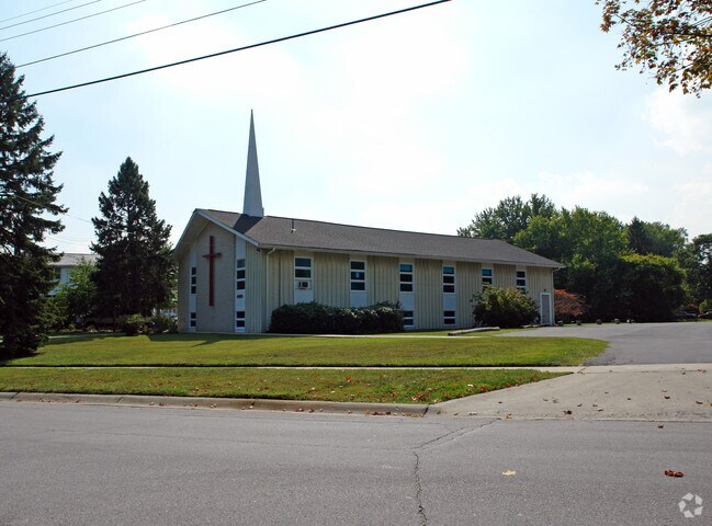
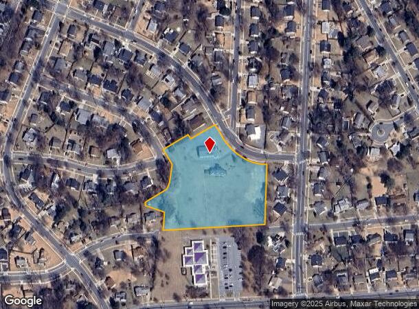
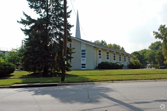
Property Record
4410 Renn St, Rockville, MD 20853
NEARBY LISTINGS FOR SALE OR LEASE
-
-
View all Rockville listings for sale on LoopNet.com
Property Detail
4410 Renn St
13-00952014
Clouin Course & Dublin Farm
Religious
PAR A VA CONE WESLEY METH CH AM PROP
X
Montgomery
24031C0355D
Maryland
2024
3.77 AC
2025
Kensington/Wheaton
703201
Washington, DC
5,746 SF
Washington-Arlington-Alexandria, DC-VA-MD-WV
DEMOGRAPHICS near 4410 Renn St
1 Mile
3 Mile
5 Mile
2024 Total Population
20,136
158,504
322,733
2029 Population
19,815
156,562
319,031
Pop Growth 2024-2029
(1.59%)
(1.23%)
(1.15%)
Average Age
38
41
41
2024 Total Households
6,036
57,177
118,927
HH Growth 2024-2029
(1.76%)
(1.22%)
(1.21%)
Median Household Inc
$102,595
$94,038
$111,565
Avg Household Size
3.20
2.60
2.60
2024 Avg HH Vehicles
2.00
2.00
2.00
Median Home Value
$435,874
$427,951
$536,271
Median Year Built
1964
1971
1973
Nearby Places
Map Layers
Map Styles
 Street
 Aerial
- Restaurants
- Banks
- Shops
- Fitness
- Groceries
PUBLIC TRANSPORTATION
COMMUTER RAIL
Rockville (Brunswick Line - Maryland Area Regional Commuter Trains (The MARC))
DRIVE
WALK
Distance
Rockville (Brunswick Line - Maryland Area Regional Commuter Trains (The MARC))
9 min
4.0 mi
Kensington (Brunswick Line - Maryland Area Regional Commuter Trains (The MARC))
DRIVE
WALK
Distance
Kensington (Brunswick Line - Maryland Area Regional Commuter Trains (The MARC))
10 min
4.5 mi
AIRPORT
Ronald Reagan Washington Ntl
DRIVE
WALK
Distance
Ronald Reagan Washington Ntl
37 min
19.2 mi
Washington Dulles International
DRIVE
WALK
Distance
Washington Dulles International
51 min
28.8 mi
Baltimore/Washington International Thurgood Marshall
DRIVE
WALK
Distance
Baltimore/Washington International Thurgood Marshall
45 min
32.5 mi
Freight Ports
Port of Baltimore
DRIVE
WALK
Distance
Port of Baltimore
48 min
35.2 mi
Nearby Properties
Address
Land Use
TOTAL SIZE
Lot Size
Zoning
Address
Land Use
TOTAL SIZE
Lot Size
Zoning
1,332,482 SF
3.79 AC
CR2.0
Address
Land Use
TOTAL SIZE
Lot Size
Zoning
515,000 SF
5.23 AC
CR1.5
Address
Land Use
TOTAL SIZE
Lot Size
Zoning
432,000 SF
1.77 AC
CR4.0
Address
Land Use
TOTAL SIZE
Lot Size
Zoning
379,100 SF
11.80 AC
CR4.0
Address
Land Use
TOTAL SIZE
Lot Size
Zoning
380,452 SF
2.38 AC
CR3.0
Address
Land Use
TOTAL SIZE
Lot Size
Zoning
431,630 SF
25.77 AC
R60
Address
Land Use
TOTAL SIZE
Lot Size
Zoning
414,000 SF
7.28 AC
MXCD
Address
Land Use
TOTAL SIZE
Lot Size
Zoning
393,977 SF
17.88 AC
MXCD
Address
Land Use
TOTAL SIZE
Lot Size
Zoning
815,414 SF
3.27 AC
CR4.0
Address
Land Use
TOTAL SIZE
Lot Size
Zoning
674,400 SF
3.21 AC
CR3.0
Address
Land Use
TOTAL SIZE
Lot Size
Zoning
223,520 SF
2.77 AC
CR2.0
Address
Land Use
TOTAL SIZE
Lot Size
Zoning
291,194 SF
0.72 AC
CR4.0
Address
Land Use
TOTAL SIZE
Lot Size
Zoning
330,650 SF
2.89 AC
MXTD
Address
Land Use
TOTAL SIZE
Lot Size
Zoning
465,983 SF
1.38 AC
CR3.0
Address
Land Use
TOTAL SIZE
Lot Size
Zoning
643,335 SF
29.18 AC
R20
Address
Land Use
TOTAL SIZE
Lot Size
Zoning
429,137 SF
1.80 AC
CR4.0
Address
Land Use
TOTAL SIZE
Lot Size
Zoning
515,740 SF
19.97 AC
R20
Address
Land Use
TOTAL SIZE
Lot Size
Zoning
152,330 SF
CR
Address
Land Use
TOTAL SIZE
Lot Size
Zoning
418,657 SF
CR4.0
Address
Land Use
TOTAL SIZE
Lot Size
Zoning
450,248 SF
26.80 AC
R200
Address
Land Use
TOTAL SIZE
Lot Size
Zoning
258,000 SF
6.34 AC
PRC
Address
Land Use
TOTAL SIZE
Lot Size
Zoning
353,684 SF
2.48 AC
CR4.0
Address
Land Use
TOTAL SIZE
Lot Size
Zoning
164,764 SF
15.42 AC
NR0.7
Address
Land Use
TOTAL SIZE
Lot Size
Zoning
316,973 SF
29.64 AC
R90
Address
Land Use
TOTAL SIZE
Lot Size
Zoning
131,521 SF
13.40 AC
PRC
Address
Land Use
TOTAL SIZE
Lot Size
Zoning
124,920 SF
11.52 AC
CR2.2
Address
Land Use
TOTAL SIZE
Lot Size
Zoning
202,300 SF
4.01 AC
MXB
Address
Land Use
TOTAL SIZE
Lot Size
Zoning
294,082 SF
12.18 AC
R20
Address
Land Use
TOTAL SIZE
Lot Size
Zoning
193,966 SF
18.25 AC
CR2.0
Address
Land Use
TOTAL SIZE
Lot Size
Zoning
179,978 SF
12.49 AC
MXCD
The World's #1 Commercial Real Estate Marketplace
Connect with us
© 2025 CoStar Group
The information above has been obtained from sources believed reliable. While we do not doubt its accuracy we have not verified it and make no guarantee, warranty or representation about it. It is your responsibility to independently confirm its accuracy and completeness. Any projections, opinions, assumptions, or estimates used are for example only and do not represent the current or future performance of the property. The value of this transaction to you depends on tax and other factors which should be evaluated by your tax, financial, and legal advisors. You and your advisors should conduct a careful, independent investigation of the property to determine to your satisfaction the suitability of the property for your needs.