Property Record
4411 E State Highway D, Springfield, MO 65809
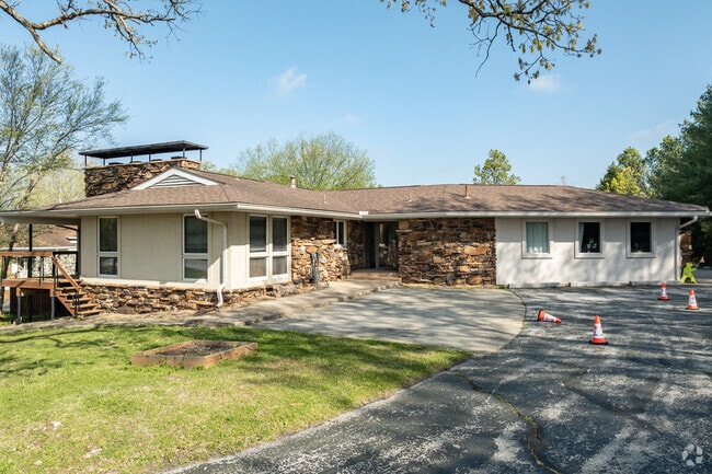

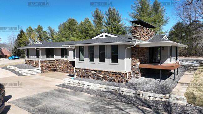
Property Detail
4411 E State Highway D
12-26-300-129
M/L BEG ON NLY R/W HWY D 249.55 FT E NW COR 26/29/21 E 1346. 1 FT M/L NWLY 383.96FT W 1033.1 FT SWLY 437.76 FT TO BEG
Officebuilding
GREENE
PAD
Missouri
B and X Area of moderate flood hazard, usually the area between the limits of the 100-year and 500-year floods.
7.55 AC
2025
Northeast
2025
Springfield
003701
Springfield, MO
10,300 SF
NEARBY LISTINGS FOR SALE OR LEASE
DEMOGRAPHICS near 4411 E State Highway D
1 mile
3 mile
5 mile
2025 Total Population
3,933
32,387
85,156
2030 Population
4,038
33,144
87,120
Pop Growth 2025-2030
+ 2.67%
+ 2.34%
+ 2.31%
Average Age
45
42
40
2025 Total Households
1,536
14,153
37,792
HH Growth 2025-2030
+ 2.86%
+ 2.47%
+ 2.47%
Median Household Inc
$137,500
$70,294
$59,149
Avg Household Size
2.60
2.20
2.10
2025 Avg HH Vehicles
2.00
2.00
2.00
Median Home Value
$392,726
$303,952
$267,621
Median Year Built
1988
1979
1976
Nearby Places
Map Layers
Map Styles
 Street
 Aerial
Layers
 Traffic
 Biking
Places
Listings with unknown addresses are not visible on the map
- Restaurants
- Banks
- Shops
- Fitness
- Groceries
PUBLIC TRANSPORTATION
AIRPORT
Springfield-Branson Ntl
Drive
Walk
Distance
Springfield-Branson Ntl
30 min
19.1 mi
SALE & LEASE HISTORY
LISTING DATE
SALE/LEASE

Jul 08, 2020
For Lease
Dec 12, 2023
For Sale
Apr 30, 2024
For Lease
Nearby Properties
Address
Land Use
TOTAL SIZE
Lot Size
Zoning
Address
Land Use
TOTAL SIZE
Lot Size
Zoning
18.35 AC
Address
Land Use
TOTAL SIZE
Lot Size
Zoning
10.29 AC
INC.
Address
Land Use
TOTAL SIZE
Lot Size
Zoning
25.51 AC
INC
Address
Land Use
TOTAL SIZE
Lot Size
Zoning
4.63 AC
O-2
Address
Land Use
TOTAL SIZE
Lot Size
Zoning
17.07 AC
INC.
Address
Land Use
TOTAL SIZE
Lot Size
Zoning
324,341 SF
43 AC
INC
Address
Land Use
TOTAL SIZE
Lot Size
Zoning
2.69 AC
INC
Address
Land Use
TOTAL SIZE
Lot Size
Zoning
26,240 SF
2.39 AC
INC.
Address
Land Use
TOTAL SIZE
Lot Size
Zoning
2 AC
INC.
Address
Land Use
TOTAL SIZE
Lot Size
Zoning
162,312 SF
7.84 AC
INC
Address
Land Use
TOTAL SIZE
Lot Size
Zoning
66,686 SF
1.91 AC
INC
Address
Land Use
TOTAL SIZE
Lot Size
Zoning
323,771 SF
31.48 AC
INC
Address
Land Use
TOTAL SIZE
Lot Size
Zoning
2.96 AC
INC.
Address
Land Use
TOTAL SIZE
Lot Size
Zoning
91,885 SF
13.29 AC
INC
Address
Land Use
TOTAL SIZE
Lot Size
Zoning
48,139 SF
5.75 AC
INC
Address
Land Use
TOTAL SIZE
Lot Size
Zoning
2.52 AC
INC.
Address
Land Use
TOTAL SIZE
Lot Size
Zoning
1.44 AC
INC
Address
Land Use
TOTAL SIZE
Lot Size
Zoning
7.32 AC
INC
Address
Land Use
TOTAL SIZE
Lot Size
Zoning
16.99 AC
INC
Address
Land Use
TOTAL SIZE
Lot Size
Zoning
2.32 AC
INC
Address
Land Use
TOTAL SIZE
Lot Size
Zoning
77,930 SF
8.60 AC
INC
Address
Land Use
TOTAL SIZE
Lot Size
Zoning
47,183 SF
12.33 AC
INC
Address
Land Use
TOTAL SIZE
Lot Size
Zoning
5.98 AC
INC
Address
Land Use
TOTAL SIZE
Lot Size
Zoning
4.23 AC
PAD
Address
Land Use
TOTAL SIZE
Lot Size
Zoning
44,036 SF
3.62 AC
INC
Address
Land Use
TOTAL SIZE
Lot Size
Zoning
240,098 SF
12.33 AC
INC
Address
Land Use
TOTAL SIZE
Lot Size
Zoning
77,930 SF
6.89 AC
INC
Address
Land Use
TOTAL SIZE
Lot Size
Zoning
2.65 AC
INC.
Address
Land Use
TOTAL SIZE
Lot Size
Zoning
65,867 SF
127 AC
INC
Address
Land Use
TOTAL SIZE
Lot Size
Zoning
107,280 SF
7.75 AC
INC
The World's #1 Commercial Real Estate Marketplace
Connect with us
© 2026 CoStar Group
The information above has been obtained from sources believed reliable. While we do not doubt its accuracy we have not verified it and make no guarantee, warranty or representation about it. It is your responsibility to independently confirm its accuracy and completeness. Any projections, opinions, assumptions, or estimates used are for example only and do not represent the current or future performance of the property. The value of this transaction to you depends on tax and other factors which should be evaluated by your tax, financial, and legal advisors. You and your advisors should conduct a careful, independent investigation of the property to determine to your satisfaction the suitability of the property for your needs.