Property Record
4411 N Prairie 1775, Lubbock, TX 79416
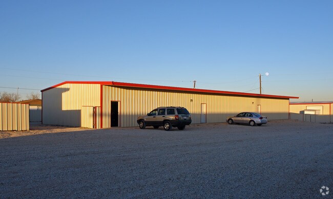

Property Detail
4411 N Prairie 1775
Lubbock, TX
BLK JS SEC 23 AB 345 TR G5 AC: 3.949
R169804
LUBBOCK
Warehouse
Texas
A Areas with a 1% annual chance of flooding and a 26% chance of flooding over the life of a 30-year mortgage.
2825
2024
3.95 AC
2025
Outlying Lubbock County
010417
Lubbock
27,199 SF
NEARBY LISTINGS FOR SALE OR LEASE
DEMOGRAPHICS near 4411 N Prairie 1775
1 mile
3 mile
5 mile
2025 Total Population
516
13,944
61,300
2030 Population
546
14,671
63,833
Pop Growth 2025-2030
+ 5.81%
+ 5.21%
+ 4.13%
Average Age
37
34
35
2025 Total Households
174
5,142
24,389
HH Growth 2025-2030
+ 6.32%
+ 5.48%
+ 4.48%
Median Household Inc
$86,931
$59,332
$52,978
Avg Household Size
2.90
2.60
2.40
2025 Avg HH Vehicles
2.00
2.00
2.00
Median Home Value
$240,909
$229,890
$195,322
Median Year Built
2004
2002
1992
Nearby Places
Map Layers
Map Styles
 Street
 Aerial
Transit
 Traffic
 Biking
Places
Listings with unknown addresses are not visible on the map
- Restaurants
- Banks
- Shops
- Fitness
- Groceries
PUBLIC TRANSPORTATION
AIRPORT
Lubbock Preston Smith International
Drive
Walk
Distance
Lubbock Preston Smith International
28 min
13.5 mi
Nearby Properties
Address
Land Use
TOTAL SIZE
Lot Size
Zoning
Address
Land Use
TOTAL SIZE
Lot Size
Zoning
103,717 SF
25.26 AC
Address
Land Use
TOTAL SIZE
Lot Size
Zoning
244,983 SF
14.26 AC
Address
Land Use
TOTAL SIZE
Lot Size
Zoning
88,803 SF
7.23 AC
Address
Land Use
TOTAL SIZE
Lot Size
Zoning
67,759 SF
6.37 AC
Address
Land Use
TOTAL SIZE
Lot Size
Zoning
41,592 SF
13.72 AC
Address
Land Use
TOTAL SIZE
Lot Size
Zoning
24,800 SF
6.74 AC
Address
Land Use
TOTAL SIZE
Lot Size
Zoning
32,819 SF
4.25 AC
Address
Land Use
TOTAL SIZE
Lot Size
Zoning
25,945 SF
3.14 AC
Address
Land Use
TOTAL SIZE
Lot Size
Zoning
43,089 SF
3.58 AC
Address
Land Use
TOTAL SIZE
Lot Size
Zoning
68,498 SF
5.44 AC
Address
Land Use
TOTAL SIZE
Lot Size
Zoning
61,842 SF
2.95 AC
Address
Land Use
TOTAL SIZE
Lot Size
Zoning
95,000 SF
5.17 AC
Address
Land Use
TOTAL SIZE
Lot Size
Zoning
13,585 SF
1.55 AC
Address
Land Use
TOTAL SIZE
Lot Size
Zoning
17.48 AC
Address
Land Use
TOTAL SIZE
Lot Size
Zoning
23,116 SF
5.94 AC
Address
Land Use
TOTAL SIZE
Lot Size
Zoning
85,350 SF
4.66 AC
Address
Land Use
TOTAL SIZE
Lot Size
Zoning
82,000 SF
16.19 AC
Address
Land Use
TOTAL SIZE
Lot Size
Zoning
80,912 SF
21.03 AC
Address
Land Use
TOTAL SIZE
Lot Size
Zoning
11,779 SF
3.12 AC
Address
Land Use
TOTAL SIZE
Lot Size
Zoning
75,495 SF
8.55 AC
Address
Land Use
TOTAL SIZE
Lot Size
Zoning
29,633 SF
4.87 AC
Address
Land Use
TOTAL SIZE
Lot Size
Zoning
11.46 AC
Address
Land Use
TOTAL SIZE
Lot Size
Zoning
26,500 SF
2.34 AC
Address
Land Use
TOTAL SIZE
Lot Size
Zoning
64,304 SF
7.06 AC
Address
Land Use
TOTAL SIZE
Lot Size
Zoning
6,548 SF
1.92 AC
Address
Land Use
TOTAL SIZE
Lot Size
Zoning
5,000 SF
4 AC
Address
Land Use
TOTAL SIZE
Lot Size
Zoning
51,072 SF
8.40 AC
Address
Land Use
TOTAL SIZE
Lot Size
Zoning
4,733 SF
44.69 AC
Address
Land Use
TOTAL SIZE
Lot Size
Zoning
17,769 SF
3 AC
Address
Land Use
TOTAL SIZE
Lot Size
Zoning
12,059 SF
1.37 AC
The World's #1 Commercial Real Estate Marketplace
Connect with us
© 2026 CoStar Group
The information above has been obtained from sources believed reliable. While we do not doubt its accuracy we have not verified it and make no guarantee, warranty or representation about it. It is your responsibility to independently confirm its accuracy and completeness. Any projections, opinions, assumptions, or estimates used are for example only and do not represent the current or future performance of the property. The value of this transaction to you depends on tax and other factors which should be evaluated by your tax, financial, and legal advisors. You and your advisors should conduct a careful, independent investigation of the property to determine to your satisfaction the suitability of the property for your needs.