Property Record
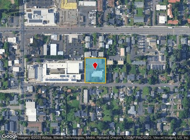
4411 Ne Emerson St, Portland, OR 97218
NEARBY LISTINGS FOR SALE OR LEASE
-
-
View all Portland listings for sale on LoopNet.com
Property Detail
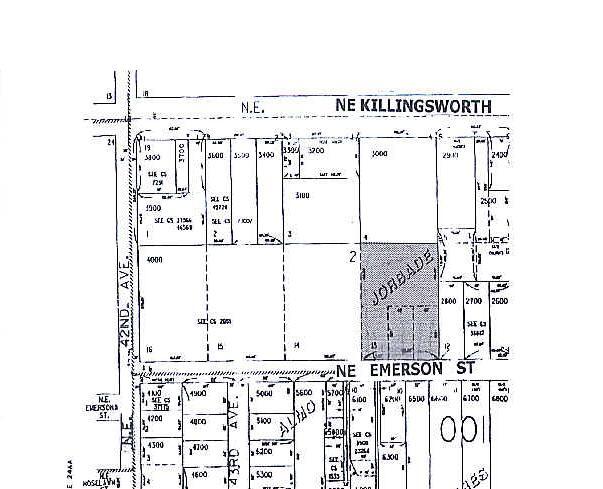
4411 Ne Emerson St
Portland-Vancouver-Hillsboro, OR-WA
Jorbade
R531987
JORBADE, BLOCK 2, LOT 13
Commercialnec
Multnomah
ARE
Oregon
53011C0525D
13
0
0.92 AC
2025
Gateway
007500
Portland
7,790 SF
DEMOGRAPHICS near 4411 Ne Emerson St
1 Mile
3 Mile
5 Mile
2024 Total Population
19,179
142,021
392,342
2029 Population
18,645
139,038
389,094
Pop Growth 2024-2029
(2.78%)
(2.10%)
(0.83%)
Average Age
40
40
40
2024 Total Households
7,551
61,908
181,620
HH Growth 2024-2029
(3.18%)
(2.28%)
(0.90%)
Median Household Inc
$96,037
$89,556
$80,086
Avg Household Size
2.40
2.20
2.00
2024 Avg HH Vehicles
2.00
2.00
1.00
Median Home Value
$611,707
$638,175
$575,455
Median Year Built
1948
1948
1960
Nearby Places
Map Layers
Map Styles
 Street
 Aerial
- Restaurants
- Banks
- Shops
- Fitness
- Groceries
PUBLIC TRANSPORTATION
COMMUTER RAIL
DRIVE
WALK
Distance
15 min
5.9 mi
DRIVE
WALK
Distance
18 min
8.3 mi
AIRPORT
Portland International
DRIVE
WALK
Distance
Portland International
12 min
4.3 mi
Freight Ports
Port of Portland
DRIVE
WALK
Distance
Port of Portland
16 min
8.4 mi
SALE & LEASE HISTORY
LISTING DATE
SALE/LEASE

Sep 14, 2017
For Sale
Nearby Properties
Address
Land Use
TOTAL SIZE
Lot Size
Zoning
Address
Land Use
TOTAL SIZE
Lot Size
Zoning
1,405,000 SF
16.51 AC
IG2
Address
Land Use
TOTAL SIZE
Lot Size
Zoning
395,815 SF
2.66 AC
IRD
Address
Land Use
TOTAL SIZE
Lot Size
Zoning
15,473 SF
192.67 AC
IG2
Address
Land Use
TOTAL SIZE
Lot Size
Zoning
417,324 SF
0.68 AC
CX
Address
Land Use
TOTAL SIZE
Lot Size
Zoning
178,785 SF
10.20 AC
R5
Address
Land Use
TOTAL SIZE
Lot Size
Zoning
197,027 SF
28.54 AC
R7H
Address
Land Use
TOTAL SIZE
Lot Size
Zoning
817,845 SF
22.54 AC
IG2
Address
Land Use
TOTAL SIZE
Lot Size
Zoning
296,039 SF
11.70 AC
R5
Address
Land Use
TOTAL SIZE
Lot Size
Zoning
7.78 AC
EX
Address
Land Use
TOTAL SIZE
Lot Size
Zoning
183,664 SF
8.96 AC
R5
Address
Land Use
TOTAL SIZE
Lot Size
Zoning
Address
Land Use
TOTAL SIZE
Lot Size
Zoning
243,371 SF
0.67 AC
CI2
Address
Land Use
TOTAL SIZE
Lot Size
Zoning
193,898 SF
2.50 AC
IRD
Address
Land Use
TOTAL SIZE
Lot Size
Zoning
134,398 SF
3.17 AC
CG
Address
Land Use
TOTAL SIZE
Lot Size
Zoning
23.95 AC
IG2
Address
Land Use
TOTAL SIZE
Lot Size
Zoning
126.43 AC
IG2
Address
Land Use
TOTAL SIZE
Lot Size
Zoning
356,805 SF
27.10 AC
EG2
Address
Land Use
TOTAL SIZE
Lot Size
Zoning
2,218,439 SF
21.88 AC
CX
Address
Land Use
TOTAL SIZE
Lot Size
Zoning
126.40 AC
IG2
Address
Land Use
TOTAL SIZE
Lot Size
Zoning
105.72 AC
IG2
Address
Land Use
TOTAL SIZE
Lot Size
Zoning
85,000 SF
1.65 AC
CI2
Address
Land Use
TOTAL SIZE
Lot Size
Zoning
97,000 SF
NULL
Address
Land Use
TOTAL SIZE
Lot Size
Zoning
107,958 SF
2.48 AC
IG2
Address
Land Use
TOTAL SIZE
Lot Size
Zoning
40,595 SF
1.99 AC
IRD
Address
Land Use
TOTAL SIZE
Lot Size
Zoning
96,554 SF
2.02 AC
CM3
Address
Land Use
TOTAL SIZE
Lot Size
Zoning
320,732 SF
1.14 AC
CX
Address
Land Use
TOTAL SIZE
Lot Size
Zoning
152,575 SF
5.32 AC
EG1
Address
Land Use
TOTAL SIZE
Lot Size
Zoning
11,375 SF
1.46 AC
CI2
Address
Land Use
TOTAL SIZE
Lot Size
Zoning
133.11 AC
IG2
Address
Land Use
TOTAL SIZE
Lot Size
Zoning
64,673 SF
NULL
The World's #1 Commercial Real Estate Marketplace
Connect with us
© 2026 CoStar Group
The information above has been obtained from sources believed reliable. While we do not doubt its accuracy we have not verified it and make no guarantee, warranty or representation about it. It is your responsibility to independently confirm its accuracy and completeness. Any projections, opinions, assumptions, or estimates used are for example only and do not represent the current or future performance of the property. The value of this transaction to you depends on tax and other factors which should be evaluated by your tax, financial, and legal advisors. You and your advisors should conduct a careful, independent investigation of the property to determine to your satisfaction the suitability of the property for your needs.