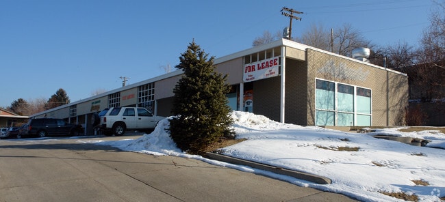
Property Record
4411 S 2950 E, Salt Lake City, UT 84124


NEARBY LISTINGS FOR SALE OR LEASE
Property Detail
4411 S 2950 E
Salt Lake City, UT
Holladay Hills No 3
22-02-180-007-0000
S 113.6 FT OF LOT 360 & ALL LOT 361 HOLLADAY HILLS NO 3 5853-1179 5859-0762 7157-1026 7447-2142 7466-0329 09951-357311008-7289 11020-7471
Stripcommercialcenter
Salt Lake
X
Utah
49035C0316H
360-3
2024
0.64 AC
2025
Central Valley East
110600
Salt Lake City
6,840 SF
DEMOGRAPHICS near 4411 S 2950 E
1 Mile
3 Mile
5 Mile
2024 Total Population
14,178
79,530
226,453
2029 Population
14,251
80,011
228,733
Pop Growth 2024-2029
+ 0.51%
+ 0.60%
+ 1.01%
Average Age
41
41
39
2024 Total Households
4,821
29,983
91,074
HH Growth 2024-2029
+ 0.37%
+ 0.51%
+ 0.99%
Median Household Inc
$129,445
$96,807
$81,708
Avg Household Size
2.90
2.60
2.40
2024 Avg HH Vehicles
2.00
2.00
2.00
Median Home Value
$733,877
$678,505
$580,652
Median Year Built
1963
1968
1972
Nearby Places
Map Layers
Map Styles
 Street
 Aerial
- Restaurants
- Banks
- Shops
- Fitness
- Groceries
PUBLIC TRANSPORTATION
AIRPORT
Salt Lake City International
DRIVE
WALK
Distance
Salt Lake City International
22 min
17.1 mi
Freight Ports
Port of Stockton
DRIVE
WALK
Distance
Port of Stockton
723 min
707.5 mi
SALE & LEASE HISTORY
LISTING DATE
SALE/LEASE

May 01, 2020
For Sale
Nearby Properties
Address
Land Use
TOTAL SIZE
Lot Size
Zoning
Address
Land Use
TOTAL SIZE
Lot Size
Zoning
207,140 SF
23.06 AC
P
Address
Land Use
TOTAL SIZE
Lot Size
Zoning
257,003 SF
25.87 AC
1108
Address
Land Use
TOTAL SIZE
Lot Size
Zoning
691,463 SF
17.80 AC
RM
Address
Land Use
TOTAL SIZE
Lot Size
Zoning
524,108 SF
34.46 AC
RM
Address
Land Use
TOTAL SIZE
Lot Size
Zoning
21,057 SF
17.96 AC
RM20
Address
Land Use
TOTAL SIZE
Lot Size
Zoning
125,518 SF
11.03 AC
RMZC
Address
Land Use
TOTAL SIZE
Lot Size
Zoning
99,702 SF
12.73 AC
R-M
Address
Land Use
TOTAL SIZE
Lot Size
Zoning
317,495 SF
2.75 AC
O-R-D
Address
Land Use
TOTAL SIZE
Lot Size
Zoning
433,385 SF
3.64 AC
R/M-U
Address
Land Use
TOTAL SIZE
Lot Size
Zoning
132,942 SF
18 AC
1108
Address
Land Use
TOTAL SIZE
Lot Size
Zoning
150,570 SF
12.76 AC
ORD
Address
Land Use
TOTAL SIZE
Lot Size
Zoning
106,467 SF
4.41 AC
2000
Address
Land Use
TOTAL SIZE
Lot Size
Zoning
176,372 SF
3.68 AC
ORD
Address
Land Use
TOTAL SIZE
Lot Size
Zoning
152,184 SF
4.40 AC
ORD
Address
Land Use
TOTAL SIZE
Lot Size
Zoning
125,789 SF
24.19 AC
1110
Address
Land Use
TOTAL SIZE
Lot Size
Zoning
78,330 SF
3 AC
O-R-D
Address
Land Use
TOTAL SIZE
Lot Size
Zoning
105,015 SF
3.91 AC
O R D
Address
Land Use
TOTAL SIZE
Lot Size
Zoning
171,805 SF
3.95 AC
ORD
Address
Land Use
TOTAL SIZE
Lot Size
Zoning
40,414 SF
3.81 AC
C-2
Address
Land Use
TOTAL SIZE
Lot Size
Zoning
479,027 SF
1.98 AC
C3
Address
Land Use
TOTAL SIZE
Lot Size
Zoning
206,860 SF
3.57 AC
O-R-D
Address
Land Use
TOTAL SIZE
Lot Size
Zoning
47,785 SF
8.11 AC
P
Address
Land Use
TOTAL SIZE
Lot Size
Zoning
89,546 SF
5.03 AC
1110
Address
Land Use
TOTAL SIZE
Lot Size
Zoning
127,748 SF
8.87 AC
1210
Address
Land Use
TOTAL SIZE
Lot Size
Zoning
188,750 SF
1.01 AC
O-R-D
Address
Land Use
TOTAL SIZE
Lot Size
Zoning
181,772 SF
11.75 AC
C-D-C
Address
Land Use
TOTAL SIZE
Lot Size
Zoning
83,690 SF
3.67 AC
ORD
Address
Land Use
TOTAL SIZE
Lot Size
Zoning
115,128 SF
9.59 AC
1108
Address
Land Use
TOTAL SIZE
Lot Size
Zoning
177,585 SF
4.65 AC
O-R-D
Address
Land Use
TOTAL SIZE
Lot Size
Zoning
78,833 SF
5.19 AC
O-R-D
The World's #1 Commercial Real Estate Marketplace
Connect with us
© 2026 CoStar Group
The information above has been obtained from sources believed reliable. While we do not doubt its accuracy we have not verified it and make no guarantee, warranty or representation about it. It is your responsibility to independently confirm its accuracy and completeness. Any projections, opinions, assumptions, or estimates used are for example only and do not represent the current or future performance of the property. The value of this transaction to you depends on tax and other factors which should be evaluated by your tax, financial, and legal advisors. You and your advisors should conduct a careful, independent investigation of the property to determine to your satisfaction the suitability of the property for your needs.