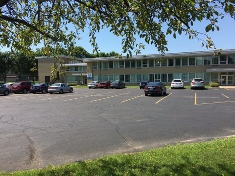
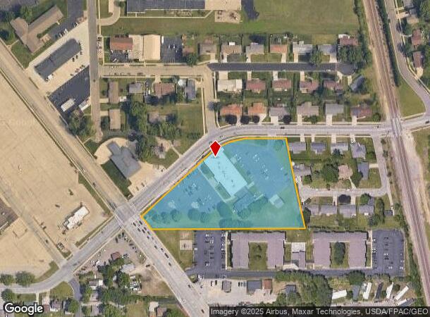
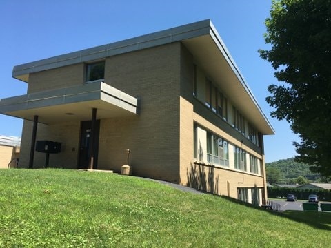
Property Record
4415 Mormon Coulee Rd, La Crosse, WI 54601
NEARBY LISTINGS FOR SALE OR LEASE
Property Detail
4415 Mormon Coulee Rd
017-050595-010
Certified Survey Map No 35 Vol
Commercialnec
CERTIFIED SURVEY MAP NO. 35 VOL 1 EX BEG INTER NELY R/W USH-14/61 & NWLY R/W BROAD- VIEW PL N38D19M0SW 166.33FT S88D35M0SE 253.30FT TO NWLY R/W BROADVIEW PL S50D28M0SW 194.70FT TO POB & EX PRT FOR RD LOT SZ: 3.929AC
X
La Crosse
27055C0115E
Wisconsin
2023
3.93 AC
2023
La Crosse/Onalaska
001102
Other Market Areas
34,284 SF
La Crosse-Onalaska, WI-MN
DEMOGRAPHICS near 4415 Mormon Coulee Rd
1 Mile
3 Mile
5 Mile
2024 Total Population
9,820
34,544
54,271
2029 Population
10,227
35,127
55,054
Pop Growth 2024-2029
+ 4.14%
+ 1.69%
+ 1.44%
Average Age
44
41
38
2024 Total Households
4,775
15,814
23,367
HH Growth 2024-2029
+ 4.36%
+ 1.73%
+ 1.62%
Median Household Inc
$53,620
$57,658
$50,138
Avg Household Size
2.00
2.10
2.10
2024 Avg HH Vehicles
1.00
2.00
2.00
Median Home Value
$176,121
$181,794
$187,182
Median Year Built
1978
1966
1969
Nearby Places
Map Layers
Map Styles
 Street
 Aerial
- Restaurants
- Banks
- Shops
- Fitness
- Groceries
PUBLIC TRANSPORTATION
COMMUTER RAIL
La Crosse (Empire Builder - Amtrak)
DRIVE
WALK
Distance
La Crosse (Empire Builder - Amtrak)
13 min
6.1 mi
AIRPORT
La Crosse Regional
DRIVE
WALK
Distance
La Crosse Regional
22 min
12.5 mi
Freight Ports
Port Milwaukee
DRIVE
WALK
Distance
Port Milwaukee
240 min
213.3 mi
SALE & LEASE HISTORY
LISTING DATE
SALE/LEASE

Jul 28, 2017
For Sale
Jan 23, 2020
For Lease
Jan 23, 2020
For Lease
Nearby Properties
Address
Land Use
TOTAL SIZE
Lot Size
Zoning
Address
Land Use
TOTAL SIZE
Lot Size
Zoning
4.65 AC
Address
Land Use
TOTAL SIZE
Lot Size
Zoning
38,407 SF
3.12 AC
MZA
Address
Land Use
TOTAL SIZE
Lot Size
Zoning
11.56 AC
Address
Land Use
TOTAL SIZE
Lot Size
Zoning
54,884 SF
1.09 AC
MZA
Address
Land Use
TOTAL SIZE
Lot Size
Zoning
10.21 AC
MZA
Address
Land Use
TOTAL SIZE
Lot Size
Zoning
186,812 SF
15.04 AC
MZA
Address
Land Use
TOTAL SIZE
Lot Size
Zoning
0.56 AC
MZA
Address
Land Use
TOTAL SIZE
Lot Size
Zoning
32,153 SF
3.16 AC
MZA
Address
Land Use
TOTAL SIZE
Lot Size
Zoning
15.48 AC
MZA
Address
Land Use
TOTAL SIZE
Lot Size
Zoning
32.76 AC
MZA
Address
Land Use
TOTAL SIZE
Lot Size
Zoning
4.71 AC
Address
Land Use
TOTAL SIZE
Lot Size
Zoning
5.01 AC
MZA
Address
Land Use
TOTAL SIZE
Lot Size
Zoning
3.04 AC
MZA
Address
Land Use
TOTAL SIZE
Lot Size
Zoning
6.01 AC
MZA
Address
Land Use
TOTAL SIZE
Lot Size
Zoning
3.46 AC
MZA
Address
Land Use
TOTAL SIZE
Lot Size
Zoning
10.61 AC
MZA
Address
Land Use
TOTAL SIZE
Lot Size
Zoning
0.50 AC
Address
Land Use
TOTAL SIZE
Lot Size
Zoning
0.37 AC
MZA
Address
Land Use
TOTAL SIZE
Lot Size
Zoning
6.01 AC
MZA
Address
Land Use
TOTAL SIZE
Lot Size
Zoning
4.71 AC
MZA
Address
Land Use
TOTAL SIZE
Lot Size
Zoning
31,104 SF
0.82 AC
Address
Land Use
TOTAL SIZE
Lot Size
Zoning
25.06 AC
MZA
Address
Land Use
TOTAL SIZE
Lot Size
Zoning
1.58 AC
MZA
Address
Land Use
TOTAL SIZE
Lot Size
Zoning
4.88 AC
MZA
Address
Land Use
TOTAL SIZE
Lot Size
Zoning
0.64 AC
MZA
Address
Land Use
TOTAL SIZE
Lot Size
Zoning
Address
Land Use
TOTAL SIZE
Lot Size
Zoning
2.99 AC
MZA
Address
Land Use
TOTAL SIZE
Lot Size
Zoning
4.58 AC
MZA
Address
Land Use
TOTAL SIZE
Lot Size
Zoning
2.96 AC
MZA
Address
Land Use
TOTAL SIZE
Lot Size
Zoning
4.22 AC
MZA
The World's #1 Commercial Real Estate Marketplace
Connect with us
© 2026 CoStar Group
The information above has been obtained from sources believed reliable. While we do not doubt its accuracy we have not verified it and make no guarantee, warranty or representation about it. It is your responsibility to independently confirm its accuracy and completeness. Any projections, opinions, assumptions, or estimates used are for example only and do not represent the current or future performance of the property. The value of this transaction to you depends on tax and other factors which should be evaluated by your tax, financial, and legal advisors. You and your advisors should conduct a careful, independent investigation of the property to determine to your satisfaction the suitability of the property for your needs.