Property Record
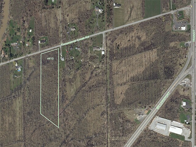
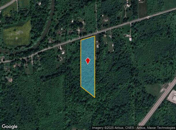
4415 Tonawanda Creek Rd, East Amherst, NY 14051
NEARBY LISTINGS FOR SALE OR LEASE
Property Detail
4415 Tonawanda Creek Rd
Buffalo-Cheektowaga-Niagara Falls, NY
Holland Land Companys Survey
142289-004-000-0002-030-200
Erie
Residentialacreage
New York
X
30.200
36029C0079H
6.81 AC
2025
North
2024
Buffalo/Niagara Falls
009009
DEMOGRAPHICS near 4415 Tonawanda Creek Rd
1 Mile
3 Mile
5 Mile
2024 Total Population
993
12,870
49,248
2029 Population
983
12,755
48,989
Pop Growth 2024-2029
(1.01%)
(0.89%)
(0.53%)
Average Age
42
42
42
2024 Total Households
396
5,306
19,560
HH Growth 2024-2029
(1.26%)
(1.02%)
(0.62%)
Median Household Inc
$85,166
$86,850
$97,725
Avg Household Size
2.50
2.40
2.50
2024 Avg HH Vehicles
2.00
2.00
2.00
Median Home Value
$254,088
$251,417
$292,515
Median Year Built
1985
1989
1987
Nearby Places
- Restaurants
- Banks
- Shops
- Fitness
- Groceries
PUBLIC TRANSPORTATION
AIRPORT
Buffalo Niagara International
DRIVE
WALK
Distance
Buffalo Niagara International
18 min
11.8 mi
Niagara Falls International
DRIVE
WALK
Distance
Niagara Falls International
28 min
17.8 mi
Freight Ports
Albany, NY Port
DRIVE
WALK
Distance
Albany, NY Port
338 min
288.0 mi
SALE & LEASE HISTORY
LISTING DATE
SALE/LEASE

Sep 24, 2016
For Sale
Nearby Properties
Address
Land Use
TOTAL SIZE
Lot Size
Zoning
Address
Land Use
TOTAL SIZE
Lot Size
Zoning
5,364 SF
56.45 AC
Address
Land Use
TOTAL SIZE
Lot Size
Zoning
4,436 SF
18.51 AC
Address
Land Use
TOTAL SIZE
Lot Size
Zoning
9,338 SF
6.20 AC
Address
Land Use
TOTAL SIZE
Lot Size
Zoning
280 SF
31 AC
Address
Land Use
TOTAL SIZE
Lot Size
Zoning
37,183 SF
62.32 AC
RC
Address
Land Use
TOTAL SIZE
Lot Size
Zoning
792 SF
20.30 AC
Address
Land Use
TOTAL SIZE
Lot Size
Zoning
51,125 SF
12.20 AC
Address
Land Use
TOTAL SIZE
Lot Size
Zoning
21,216 SF
3.90 AC
Address
Land Use
TOTAL SIZE
Lot Size
Zoning
40,871 SF
27.20 AC
Address
Land Use
TOTAL SIZE
Lot Size
Zoning
36,725 SF
7 AC
B-2
Address
Land Use
TOTAL SIZE
Lot Size
Zoning
5,000 SF
2.60 AC
Address
Land Use
TOTAL SIZE
Lot Size
Zoning
884 SF
35 AC
Address
Land Use
TOTAL SIZE
Lot Size
Zoning
78,640 SF
15.60 AC
R-2 RESI
Address
Land Use
TOTAL SIZE
Lot Size
Zoning
4.23 AC
Address
Land Use
TOTAL SIZE
Lot Size
Zoning
29.10 AC
Address
Land Use
TOTAL SIZE
Lot Size
Zoning
40,599 SF
5.90 AC
R-2
Address
Land Use
TOTAL SIZE
Lot Size
Zoning
7,553 SF
175.27 AC
CF
Address
Land Use
TOTAL SIZE
Lot Size
Zoning
6,108 SF
1.50 AC
Address
Land Use
TOTAL SIZE
Lot Size
Zoning
Address
Land Use
TOTAL SIZE
Lot Size
Zoning
20,147 SF
3.99 AC
B-1
Address
Land Use
TOTAL SIZE
Lot Size
Zoning
13.68 AC
Address
Land Use
TOTAL SIZE
Lot Size
Zoning
17,800 SF
4.44 AC
Address
Land Use
TOTAL SIZE
Lot Size
Zoning
95,936 SF
8.30 AC
Address
Land Use
TOTAL SIZE
Lot Size
Zoning
22,311 SF
45.40 AC
Address
Land Use
TOTAL SIZE
Lot Size
Zoning
21,340 SF
12.20 AC
Address
Land Use
TOTAL SIZE
Lot Size
Zoning
24,610 SF
3.30 AC
Address
Land Use
TOTAL SIZE
Lot Size
Zoning
6,714 SF
6.90 AC
MA
Address
Land Use
TOTAL SIZE
Lot Size
Zoning
4,488 SF
9.64 AC
SA
Address
Land Use
TOTAL SIZE
Lot Size
Zoning
2,400 SF
199.40 AC
Address
Land Use
TOTAL SIZE
Lot Size
Zoning
12,708 SF
6.68 AC
SA
The World's #1 Commercial Real Estate Marketplace
Connect with us
© 2025 CoStar Group
The information above has been obtained from sources believed reliable. While we do not doubt its accuracy we have not verified it and make no guarantee, warranty or representation about it. It is your responsibility to independently confirm its accuracy and completeness. Any projections, opinions, assumptions, or estimates used are for example only and do not represent the current or future performance of the property. The value of this transaction to you depends on tax and other factors which should be evaluated by your tax, financial, and legal advisors. You and your advisors should conduct a careful, independent investigation of the property to determine to your satisfaction the suitability of the property for your needs.