Property Record
4416 Groometown Rd, Greensboro, NC 27407
NEARBY LISTINGS FOR SALE OR LEASE
-
-
View all Greensboro listings for sale on LoopNet.com
Property Detail
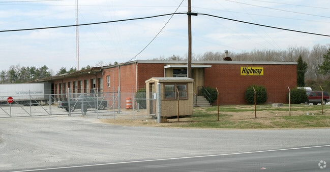
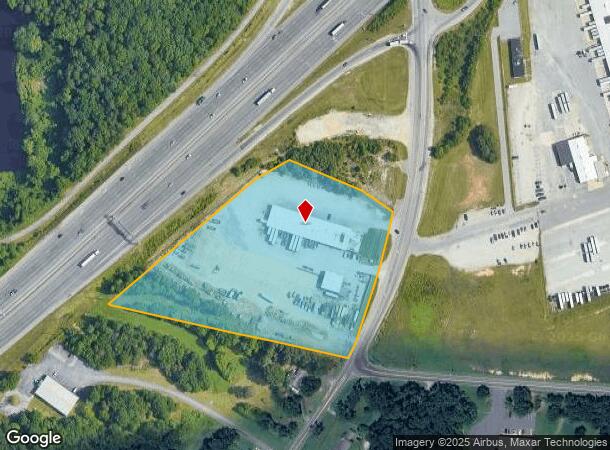
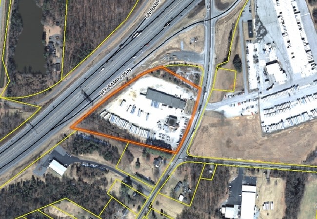
4416 Groometown Rd
Greensboro-High Point, NC
Groometown
0141484
HIGHWAY EXPRESS/GROOMETOWN @ I-85
Industrialgeneral
Guilford
X
North Carolina
3710784100J
16
2024
7.45 AC
2025
Central Guilford County
016701
Greensboro/Winston-Salem
41,520 SF
DEMOGRAPHICS near 4416 Groometown Rd
1 Mile
3 Mile
5 Mile
2024 Total Population
996
28,009
98,939
2029 Population
1,004
27,929
98,385
Pop Growth 2024-2029
+ 0.80%
(0.29%)
(0.56%)
Average Age
43
40
39
2024 Total Households
413
11,469
41,126
HH Growth 2024-2029
+ 0.73%
(0.30%)
(0.55%)
Median Household Inc
$69,999
$59,756
$56,058
Avg Household Size
2.40
2.40
2.30
2024 Avg HH Vehicles
2.00
2.00
2.00
Median Home Value
$286,065
$183,673
$167,437
Median Year Built
1985
1985
1986
Nearby Places
Map Layers
Map Styles
 Street
 Aerial
- Restaurants
- Banks
- Shops
- Fitness
- Groceries
PUBLIC TRANSPORTATION
AIRPORT
Piedmont Triad International
DRIVE
WALK
Distance
Piedmont Triad International
16 min
11.7 mi
Nearby Properties
Address
Land Use
TOTAL SIZE
Lot Size
Zoning
Address
Land Use
TOTAL SIZE
Lot Size
Zoning
1,307,155 SF
60.56 AC
C-H
Address
Land Use
TOTAL SIZE
Lot Size
Zoning
341,210 SF
13.43 AC
PUD
Address
Land Use
TOTAL SIZE
Lot Size
Zoning
536,466 SF
46.90 AC
PUD
Address
Land Use
TOTAL SIZE
Lot Size
Zoning
419,281 SF
25.12 AC
CIV
Address
Land Use
TOTAL SIZE
Lot Size
Zoning
228,994 SF
15.59 AC
PUD
Address
Land Use
TOTAL SIZE
Lot Size
Zoning
231,597 SF
8.46 AC
PD-R
Address
Land Use
TOTAL SIZE
Lot Size
Zoning
395,043 SF
15.74 AC
PUD
Address
Land Use
TOTAL SIZE
Lot Size
Zoning
177,780 SF
11.80 AC
PUD
Address
Land Use
TOTAL SIZE
Lot Size
Zoning
211,723 SF
20.24 AC
RM-18
Address
Land Use
TOTAL SIZE
Lot Size
Zoning
403,590 SF
72.06 AC
CIV
Address
Land Use
TOTAL SIZE
Lot Size
Zoning
144,746 SF
8.17 AC
AG
Address
Land Use
TOTAL SIZE
Lot Size
Zoning
250,084 SF
5.46 AC
PI
Address
Land Use
TOTAL SIZE
Lot Size
Zoning
173,887 SF
12.46 AC
RM-18
Address
Land Use
TOTAL SIZE
Lot Size
Zoning
188,976 SF
41.46 AC
R-5
Address
Land Use
TOTAL SIZE
Lot Size
Zoning
272,917 SF
33.57 AC
MS
Address
Land Use
TOTAL SIZE
Lot Size
Zoning
134,008 SF
10.48 AC
RM-18
Address
Land Use
TOTAL SIZE
Lot Size
Zoning
91,414 SF
11.72 AC
C-H
Address
Land Use
TOTAL SIZE
Lot Size
Zoning
87,514 SF
40.62 AC
O
Address
Land Use
TOTAL SIZE
Lot Size
Zoning
89,901 SF
10.65 AC
RM-12
Address
Land Use
TOTAL SIZE
Lot Size
Zoning
107,867 SF
14.75 AC
RM-8
Address
Land Use
TOTAL SIZE
Lot Size
Zoning
92,927 SF
6.22 AC
RM-18
Address
Land Use
TOTAL SIZE
Lot Size
Zoning
79,022 SF
6.52 AC
CIV
Address
Land Use
TOTAL SIZE
Lot Size
Zoning
161,556 SF
47.70 AC
HI
Address
Land Use
TOTAL SIZE
Lot Size
Zoning
95,304 SF
4.58 AC
RM-12
Address
Land Use
TOTAL SIZE
Lot Size
Zoning
64,721 SF
10.65 AC
AG
Address
Land Use
TOTAL SIZE
Lot Size
Zoning
117,356 SF
10.11 AC
RM-12
Address
Land Use
TOTAL SIZE
Lot Size
Zoning
122,137 SF
17.13 AC
RM-8
Address
Land Use
TOTAL SIZE
Lot Size
Zoning
177,850 SF
93.40 AC
AG
Address
Land Use
TOTAL SIZE
Lot Size
Zoning
98,670 SF
7.60 AC
RM-18
Address
Land Use
TOTAL SIZE
Lot Size
Zoning
55,923 SF
37.65 AC
C-M
The World's #1 Commercial Real Estate Marketplace
Connect with us
© 2026 CoStar Group
The information above has been obtained from sources believed reliable. While we do not doubt its accuracy we have not verified it and make no guarantee, warranty or representation about it. It is your responsibility to independently confirm its accuracy and completeness. Any projections, opinions, assumptions, or estimates used are for example only and do not represent the current or future performance of the property. The value of this transaction to you depends on tax and other factors which should be evaluated by your tax, financial, and legal advisors. You and your advisors should conduct a careful, independent investigation of the property to determine to your satisfaction the suitability of the property for your needs.