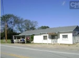
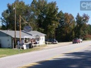
Property Record
442 Longtown Rd, Lugoff, SC 29078

NEARBY LISTINGS FOR SALE OR LEASE
Property Detail
442 Longtown Rd
268-00-00-030
2104-270 943-191 337-041 JG-93 T/0
Storebuilding
Kershaw
X
South Carolina
45055C0315F
0.31 AC
2025
Kershaw County
2025
Columbia
970401
Columbia, SC
1,536 SF
DEMOGRAPHICS near 442 Longtown Rd
1 Mile
3 Mile
5 Mile
2024 Total Population
355
5,578
19,395
2029 Population
391
6,034
21,080
Pop Growth 2024-2029
+ 10.14%
+ 8.17%
+ 8.69%
Average Age
41
40
42
2024 Total Households
126
2,185
7,723
HH Growth 2024-2029
+ 10.32%
+ 7.96%
+ 8.57%
Median Household Inc
$42,083
$41,333
$45,920
Avg Household Size
2.60
2.50
2.40
2024 Avg HH Vehicles
3.00
2.00
2.00
Median Home Value
$187,142
$163,371
$185,860
Median Year Built
1995
1990
1988
Nearby Places
Map Layers
Map Styles
 Street
 Aerial
- Restaurants
- Banks
- Shops
- Fitness
- Groceries
PUBLIC TRANSPORTATION
AIRPORT
Columbia Metro
DRIVE
WALK
Distance
Columbia Metro
65 min
42.8 mi
Nearby Properties
Address
Land Use
TOTAL SIZE
Lot Size
Zoning
Address
Land Use
TOTAL SIZE
Lot Size
Zoning
183,825 SF
20.09 AC
MUNICIPAL
Address
Land Use
TOTAL SIZE
Lot Size
Zoning
117,844 SF
12.21 AC
MUNICIPAL
Address
Land Use
TOTAL SIZE
Lot Size
Zoning
116,508 SF
14.91 AC
MUNICIPAL
Address
Land Use
TOTAL SIZE
Lot Size
Zoning
101,650 SF
8.48 AC
Address
Land Use
TOTAL SIZE
Lot Size
Zoning
72,502 SF
12 AC
GD
Address
Land Use
TOTAL SIZE
Lot Size
Zoning
37,872 SF
6.53 AC
B2
Address
Land Use
TOTAL SIZE
Lot Size
Zoning
41,160 SF
3.37 AC
Address
Land Use
TOTAL SIZE
Lot Size
Zoning
71,157 SF
7.19 AC
MUNICIPAL
Address
Land Use
TOTAL SIZE
Lot Size
Zoning
22,076 SF
3.53 AC
MUNICIPAL
Address
Land Use
TOTAL SIZE
Lot Size
Zoning
54,906 SF
4.51 AC
Address
Land Use
TOTAL SIZE
Lot Size
Zoning
8,804 SF
0.73 AC
Address
Land Use
TOTAL SIZE
Lot Size
Zoning
31,087 SF
9.63 AC
GD
Address
Land Use
TOTAL SIZE
Lot Size
Zoning
3.93 AC
B2
Address
Land Use
TOTAL SIZE
Lot Size
Zoning
87,548 SF
10 AC
GD
Address
Land Use
TOTAL SIZE
Lot Size
Zoning
64,714 SF
5.93 AC
B2
Address
Land Use
TOTAL SIZE
Lot Size
Zoning
20,359 SF
5.39 AC
RD2
Address
Land Use
TOTAL SIZE
Lot Size
Zoning
35,700 SF
2.03 AC
B2
Address
Land Use
TOTAL SIZE
Lot Size
Zoning
25,953 SF
5.63 AC
B2
Address
Land Use
TOTAL SIZE
Lot Size
Zoning
15,040 SF
2.52 AC
B2
Address
Land Use
TOTAL SIZE
Lot Size
Zoning
31,700 SF
17.76 AC
GD
Address
Land Use
TOTAL SIZE
Lot Size
Zoning
14,556 SF
4.05 AC
GD
Address
Land Use
TOTAL SIZE
Lot Size
Zoning
61,212 SF
18.36 AC
GD
Address
Land Use
TOTAL SIZE
Lot Size
Zoning
5,726 SF
1.61 AC
Address
Land Use
TOTAL SIZE
Lot Size
Zoning
40,100 SF
5.19 AC
B2
Address
Land Use
TOTAL SIZE
Lot Size
Zoning
4,356 SF
1.77 AC
MUNICIPAL
Address
Land Use
TOTAL SIZE
Lot Size
Zoning
66,790 SF
6.43 AC
GD
Address
Land Use
TOTAL SIZE
Lot Size
Zoning
53,520 SF
8.61 AC
R6
Address
Land Use
TOTAL SIZE
Lot Size
Zoning
12.77 AC
GD
Address
Land Use
TOTAL SIZE
Lot Size
Zoning
753.35 AC
RD1
Address
Land Use
TOTAL SIZE
Lot Size
Zoning
33,500 SF
2.69 AC
GD
The World's #1 Commercial Real Estate Marketplace
Connect with us
© 2025 CoStar Group
The information above has been obtained from sources believed reliable. While we do not doubt its accuracy we have not verified it and make no guarantee, warranty or representation about it. It is your responsibility to independently confirm its accuracy and completeness. Any projections, opinions, assumptions, or estimates used are for example only and do not represent the current or future performance of the property. The value of this transaction to you depends on tax and other factors which should be evaluated by your tax, financial, and legal advisors. You and your advisors should conduct a careful, independent investigation of the property to determine to your satisfaction the suitability of the property for your needs.