Property Record
4420 Highway 74 E, Wingate, NC 28174
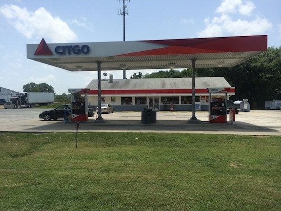

Property Detail
4420 Highway 74 E
09-024-006
7230-827
Conveniencestore
Union
B-1 WINGAT
North Carolina
B and X Area of moderate flood hazard, usually the area between the limits of the 100-year and 500-year floods.
1.88 AC
2025
Union County
2025
Charlotte
020702
Charlotte-Concord-Gastonia, NC-SC
2,736 SF
NEARBY LISTINGS FOR SALE OR LEASE
DEMOGRAPHICS near 4420 Highway 74 E
1 mile
3 mile
5 mile
2025 Total Population
3,705
8,837
22,031
2030 Population
3,911
9,484
23,921
Pop Growth 2025-2030
+ 5.56%
+ 7.32%
+ 8.58%
Average Age
32
36
38
2025 Total Households
759
2,472
7,029
HH Growth 2025-2030
+ 6.85%
+ 8.13%
+ 9.01%
Median Household Inc
$53,048
$60,285
$68,395
Avg Household Size
2.70
2.70
2.70
2025 Avg HH Vehicles
2.00
2.00
2.00
Median Home Value
$344,871
$296,568
$340,441
Median Year Built
1989
1989
1987
Nearby Places
Map Layers
Map Styles
 Street
 Aerial
Transit
 Traffic
 Biking
Places
Listings with unknown addresses are not visible on the map
- Restaurants
- Banks
- Shops
- Fitness
- Groceries
PUBLIC TRANSPORTATION
AIRPORT
Charlotte/Douglas International
Drive
Walk
Distance
Charlotte/Douglas International
58 min
39.2 mi
Concord-Padgett Regional
Drive
Walk
Distance
Concord-Padgett Regional
53 min
40.3 mi
SALE & LEASE HISTORY
LISTING DATE
SALE/LEASE

Sep 24, 2016
For Sale
Nearby Properties
Address
Land Use
TOTAL SIZE
Lot Size
Zoning
Address
Land Use
TOTAL SIZE
Lot Size
Zoning
138,123 SF
113.13 AC
B-1 WINGAT
Address
Land Use
TOTAL SIZE
Lot Size
Zoning
68,870 SF
33.25 AC
HC WINGATE
Address
Land Use
TOTAL SIZE
Lot Size
Zoning
68,258 SF
3.39 AC
R-20 WINGA
Address
Land Use
TOTAL SIZE
Lot Size
Zoning
138,165 SF
135.17 AC
HC UNION C
Address
Land Use
TOTAL SIZE
Lot Size
Zoning
28,468 SF
3.51 AC
B-1 WINGAT
Address
Land Use
TOTAL SIZE
Lot Size
Zoning
214,256 SF
16.68 AC
G-I MONROE
Address
Land Use
TOTAL SIZE
Lot Size
Zoning
88,806 SF
15.72 AC
IND MARSHV
Address
Land Use
TOTAL SIZE
Lot Size
Zoning
69,549 SF
13 AC
IND MARSHV
Address
Land Use
TOTAL SIZE
Lot Size
Zoning
28.93 AC
Address
Land Use
TOTAL SIZE
Lot Size
Zoning
40,297 SF
7.95 AC
CD MONROE
Address
Land Use
TOTAL SIZE
Lot Size
Zoning
64,743 SF
13.82 AC
R-20 WINGA
Address
Land Use
TOTAL SIZE
Lot Size
Zoning
10,274 SF
6.24 AC
R-6 WINGAT
Address
Land Use
TOTAL SIZE
Lot Size
Zoning
1,976 SF
9.55 AC
CD MONROE
Address
Land Use
TOTAL SIZE
Lot Size
Zoning
139,544 SF
17.21 AC
G-I MONROE
Address
Land Use
TOTAL SIZE
Lot Size
Zoning
164.35 AC
R-20 MONRO
Address
Land Use
TOTAL SIZE
Lot Size
Zoning
15,103 SF
2.01 AC
B-1 WINGAT
Address
Land Use
TOTAL SIZE
Lot Size
Zoning
98,000 SF
14.92 AC
G-I MONROE
Address
Land Use
TOTAL SIZE
Lot Size
Zoning
28 AC
IND MARSHV
Address
Land Use
TOTAL SIZE
Lot Size
Zoning
4,252 SF
2.60 AC
R-6 WINGAT
Address
Land Use
TOTAL SIZE
Lot Size
Zoning
28,512 SF
13.74 AC
B-1 WINGAT
Address
Land Use
TOTAL SIZE
Lot Size
Zoning
64.18 AC
CD MONROE
Address
Land Use
TOTAL SIZE
Lot Size
Zoning
72,000 SF
9.02 AC
G-I MONROE
Address
Land Use
TOTAL SIZE
Lot Size
Zoning
10.71 AC
Address
Land Use
TOTAL SIZE
Lot Size
Zoning
21,804 SF
0.48 AC
R-20 WINGA
Address
Land Use
TOTAL SIZE
Lot Size
Zoning
21,804 SF
0.92 AC
R-6 WINGAT
Address
Land Use
TOTAL SIZE
Lot Size
Zoning
17,304 SF
0.61 AC
B-6 WINGAT
Address
Land Use
TOTAL SIZE
Lot Size
Zoning
7,000 SF
37.71 AC
LI WINGATE
Address
Land Use
TOTAL SIZE
Lot Size
Zoning
25,794 SF
1.80 AC
R-6 WINGAT
Address
Land Use
TOTAL SIZE
Lot Size
Zoning
67,695 SF
6.24 AC
HC WINGATE
Address
Land Use
TOTAL SIZE
Lot Size
Zoning
92,712 SF
21.10 AC
G-I MONROE
The World's #1 Commercial Real Estate Marketplace
Connect with us
© 2026 CoStar Group
The information above has been obtained from sources believed reliable. While we do not doubt its accuracy we have not verified it and make no guarantee, warranty or representation about it. It is your responsibility to independently confirm its accuracy and completeness. Any projections, opinions, assumptions, or estimates used are for example only and do not represent the current or future performance of the property. The value of this transaction to you depends on tax and other factors which should be evaluated by your tax, financial, and legal advisors. You and your advisors should conduct a careful, independent investigation of the property to determine to your satisfaction the suitability of the property for your needs.