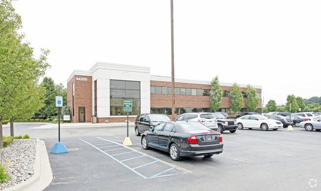
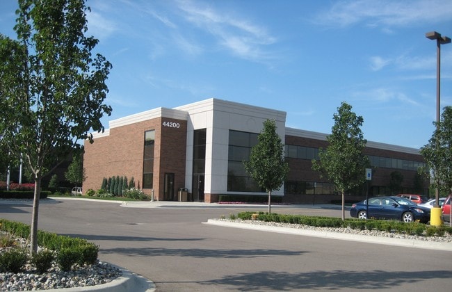
Property Record
44200 Garfield Rd, Clinton Township, MI 48038


NEARBY LISTINGS FOR SALE OR LEASE
Property Detail
44200 Garfield Rd
16-11-05-100-022
50-11-05-100-022 D69B3B & 69B3C1 & 70A 91C T2N R13E SEC 5 COMM AT A PT ON W LINE SEC 5 A DIST OF 460.29 FT DUE N OF W 1/4
Officebuilding
Macomb
X
Michigan
26099C0327G
3.55 AC
2025
Macomb East
2025
Detroit
242500
Detroit-Warren-Dearborn, MI
46,146 SF
DEMOGRAPHICS near 44200 Garfield Rd
1 Mile
3 Mile
5 Mile
2024 Total Population
13,054
113,231
256,962
2029 Population
12,966
111,707
254,120
Pop Growth 2024-2029
(0.67%)
(1.35%)
(1.11%)
Average Age
43
43
42
2024 Total Households
6,649
46,696
103,400
HH Growth 2024-2029
(0.74%)
(1.33%)
(1.14%)
Median Household Inc
$62,228
$79,023
$75,315
Avg Household Size
2.00
2.40
2.40
2024 Avg HH Vehicles
2.00
2.00
2.00
Median Home Value
$193,295
$250,519
$247,440
Median Year Built
1993
1989
1984
Nearby Places
Map Layers
Map Styles
 Street
 Aerial
- Restaurants
- Banks
- Shops
- Fitness
- Groceries
PUBLIC TRANSPORTATION
AIRPORT
Windsor International
DRIVE
WALK
Distance
Windsor International
65 min
37.9 mi
Detroit Metro Wayne County
DRIVE
WALK
Distance
Detroit Metro Wayne County
68 min
45.0 mi
SALE & LEASE HISTORY
LISTING DATE
SALE/LEASE

Apr 07, 2017
For Lease
Nearby Properties
Address
Land Use
TOTAL SIZE
Lot Size
Zoning
Address
Land Use
TOTAL SIZE
Lot Size
Zoning
426,076 SF
42.79 AC
B-4
Address
Land Use
TOTAL SIZE
Lot Size
Zoning
122.50 AC
RML
Address
Land Use
TOTAL SIZE
Lot Size
Zoning
35 AC
RML
Address
Land Use
TOTAL SIZE
Lot Size
Zoning
20,560 SF
37.09 AC
R2
Address
Land Use
TOTAL SIZE
Lot Size
Zoning
20,891 SF
289.61 AC
R3
Address
Land Use
TOTAL SIZE
Lot Size
Zoning
401,014 SF
32.54 AC
RML
Address
Land Use
TOTAL SIZE
Lot Size
Zoning
366,656 SF
30.08 AC
RM-2
Address
Land Use
TOTAL SIZE
Lot Size
Zoning
40.39 AC
RML
Address
Land Use
TOTAL SIZE
Lot Size
Zoning
22.52 AC
RMH
Address
Land Use
TOTAL SIZE
Lot Size
Zoning
182,708 SF
10.69 AC
RMH
Address
Land Use
TOTAL SIZE
Lot Size
Zoning
44.65 AC
RML
Address
Land Use
TOTAL SIZE
Lot Size
Zoning
438,578 SF
36.60 AC
MXD
Address
Land Use
TOTAL SIZE
Lot Size
Zoning
23.78 AC
RML
Address
Land Use
TOTAL SIZE
Lot Size
Zoning
182,102 SF
11.04 AC
SP-1
Address
Land Use
TOTAL SIZE
Lot Size
Zoning
20.27 AC
RML
Address
Land Use
TOTAL SIZE
Lot Size
Zoning
25.14 AC
RML
Address
Land Use
TOTAL SIZE
Lot Size
Zoning
15.94 AC
RMH
Address
Land Use
TOTAL SIZE
Lot Size
Zoning
237,108 SF
10.30 AC
R-12
Address
Land Use
TOTAL SIZE
Lot Size
Zoning
15.90 AC
RML
Address
Land Use
TOTAL SIZE
Lot Size
Zoning
26.92 AC
RML
Address
Land Use
TOTAL SIZE
Lot Size
Zoning
79,504 SF
SP-2
Address
Land Use
TOTAL SIZE
Lot Size
Zoning
17.40 AC
CK MAP
Address
Land Use
TOTAL SIZE
Lot Size
Zoning
42,385 SF
25.55 AC
B-2
Address
Land Use
TOTAL SIZE
Lot Size
Zoning
37.44 AC
RML
Address
Land Use
TOTAL SIZE
Lot Size
Zoning
50,577 SF
21.43 AC
C-2
Address
Land Use
TOTAL SIZE
Lot Size
Zoning
176,212 SF
16.46 AC
MXD
Address
Land Use
TOTAL SIZE
Lot Size
Zoning
45,000 SF
7.58 AC
B-4
Address
Land Use
TOTAL SIZE
Lot Size
Zoning
15.46 AC
RMH
Address
Land Use
TOTAL SIZE
Lot Size
Zoning
146,106 SF
6.03 AC
RM-2
Address
Land Use
TOTAL SIZE
Lot Size
Zoning
72,572 SF
10 AC
B-3
The World's #1 Commercial Real Estate Marketplace
Connect with us
© 2026 CoStar Group
The information above has been obtained from sources believed reliable. While we do not doubt its accuracy we have not verified it and make no guarantee, warranty or representation about it. It is your responsibility to independently confirm its accuracy and completeness. Any projections, opinions, assumptions, or estimates used are for example only and do not represent the current or future performance of the property. The value of this transaction to you depends on tax and other factors which should be evaluated by your tax, financial, and legal advisors. You and your advisors should conduct a careful, independent investigation of the property to determine to your satisfaction the suitability of the property for your needs.