Property Record
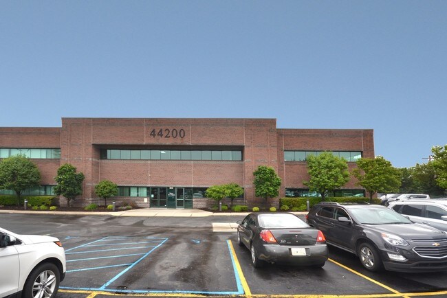
44200 Woodward Ave, Pontiac, MI 48341


NEARBY LISTINGS FOR SALE OR LEASE
Property Detail
44200 Woodward Ave
19-04-228-002
Oakland County Condominium
Storebuilding
T2N, R10E, SEC 4 OAKLAND COUNTY CONDOMINIUM PLAN NO 1966 LEXUS PROFESSIONAL BUILDING CONDOMINIUM UNIT 2 L 39911 P 515 1-11-08
X
Oakland
26125C0507F
Michigan
2024
0.12 AC
2025
Pontiac
142700
Detroit
1,921 SF
Detroit-Warren-Dearborn, MI
DEMOGRAPHICS near 44200 Woodward Ave
1 Mile
3 Mile
5 Mile
2024 Total Population
6,009
64,094
167,389
2029 Population
6,007
64,258
166,835
Pop Growth 2024-2029
(0.03%)
+ 0.26%
(0.33%)
Average Age
40
41
41
2024 Total Households
2,375
25,581
66,711
HH Growth 2024-2029
(0.25%)
+ 0.23%
(0.34%)
Median Household Inc
$39,152
$56,412
$73,957
Avg Household Size
2.50
2.40
2.40
2024 Avg HH Vehicles
2.00
2.00
2.00
Median Home Value
$144,615
$230,449
$340,029
Median Year Built
1960
1965
1968
Nearby Places
Map Layers
Map Styles
 Street
 Aerial
- Restaurants
- Banks
- Shops
- Fitness
- Groceries
PUBLIC TRANSPORTATION
COMMUTER RAIL
DRIVE
WALK
Distance
6 min
2.1 mi
DRIVE
WALK
Distance
16 min
7.8 mi
AIRPORT
Detroit Metro Wayne County
DRIVE
WALK
Distance
Detroit Metro Wayne County
60 min
34.6 mi
Windsor International
DRIVE
WALK
Distance
Windsor International
58 min
38.2 mi
Bishop International
DRIVE
WALK
Distance
Bishop International
63 min
46.0 mi
SALE & LEASE HISTORY
LISTING DATE
SALE/LEASE

Sep 10, 2020
For Sale
Nov 22, 2024
For Lease
Nov 20, 2024
For Lease
Jun 24, 2024
For Lease
Jun 24, 2024
For Sale
Jul 26, 2023
For Lease
Jul 26, 2023
For Sale
Jan 09, 2024
For Lease
Jan 09, 2024
For Sale
Aug 03, 2023
For Sale
Nearby Properties
Address
Land Use
TOTAL SIZE
Lot Size
Zoning
Address
Land Use
TOTAL SIZE
Lot Size
Zoning
2,734,739 SF
80.39 AC
Address
Land Use
TOTAL SIZE
Lot Size
Zoning
671,780 SF
Address
Land Use
TOTAL SIZE
Lot Size
Zoning
526,398 SF
32.99 AC
Address
Land Use
TOTAL SIZE
Lot Size
Zoning
711,360 SF
43.86 AC
Address
Land Use
TOTAL SIZE
Lot Size
Zoning
608,251 SF
50.49 AC
II
Address
Land Use
TOTAL SIZE
Lot Size
Zoning
131,817 SF
67 AC
SP
Address
Land Use
TOTAL SIZE
Lot Size
Zoning
374,400 SF
4.10 AC
Address
Land Use
TOTAL SIZE
Lot Size
Zoning
601,151 SF
Address
Land Use
TOTAL SIZE
Lot Size
Zoning
360,186 SF
38.44 AC
RM2
Address
Land Use
TOTAL SIZE
Lot Size
Zoning
289,110 SF
6.07 AC
BI
Address
Land Use
TOTAL SIZE
Lot Size
Zoning
101,409 SF
5.90 AC
Address
Land Use
TOTAL SIZE
Lot Size
Zoning
206,590 SF
6.14 AC
RI
Address
Land Use
TOTAL SIZE
Lot Size
Zoning
221,340 SF
26.88 AC
BI
Address
Land Use
TOTAL SIZE
Lot Size
Zoning
203,643 SF
9.85 AC
IV
Address
Land Use
TOTAL SIZE
Lot Size
Zoning
199,125 SF
47.43 AC
Address
Land Use
TOTAL SIZE
Lot Size
Zoning
205,703 SF
21.63 AC
B2
Address
Land Use
TOTAL SIZE
Lot Size
Zoning
242,512 SF
6.60 AC
BI
Address
Land Use
TOTAL SIZE
Lot Size
Zoning
156,668 SF
13.19 AC
BI
Address
Land Use
TOTAL SIZE
Lot Size
Zoning
23.28 AC
AI
Address
Land Use
TOTAL SIZE
Lot Size
Zoning
154,370 SF
8.80 AC
BI
Address
Land Use
TOTAL SIZE
Lot Size
Zoning
454,573 SF
Address
Land Use
TOTAL SIZE
Lot Size
Zoning
97,172 SF
13.82 AC
BI
Address
Land Use
TOTAL SIZE
Lot Size
Zoning
267,393 SF
11.11 AC
BI
Address
Land Use
TOTAL SIZE
Lot Size
Zoning
186,197 SF
12.11 AC
TR
Address
Land Use
TOTAL SIZE
Lot Size
Zoning
903,018 SF
73.92 AC
II
Address
Land Use
TOTAL SIZE
Lot Size
Zoning
58,661 SF
3.31 AC
BI
Address
Land Use
TOTAL SIZE
Lot Size
Zoning
93,734 SF
10.63 AC
MM
Address
Land Use
TOTAL SIZE
Lot Size
Zoning
288,124 SF
15.76 AC
Address
Land Use
TOTAL SIZE
Lot Size
Zoning
145,712 SF
10.51 AC
BV
Address
Land Use
TOTAL SIZE
Lot Size
Zoning
275,889 SF
12.34 AC
BI
The World's #1 Commercial Real Estate Marketplace
Connect with us
© 2026 CoStar Group
The information above has been obtained from sources believed reliable. While we do not doubt its accuracy we have not verified it and make no guarantee, warranty or representation about it. It is your responsibility to independently confirm its accuracy and completeness. Any projections, opinions, assumptions, or estimates used are for example only and do not represent the current or future performance of the property. The value of this transaction to you depends on tax and other factors which should be evaluated by your tax, financial, and legal advisors. You and your advisors should conduct a careful, independent investigation of the property to determine to your satisfaction the suitability of the property for your needs.