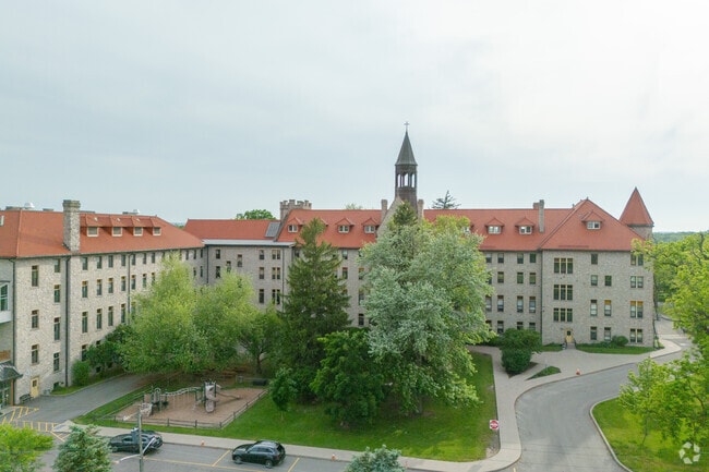
Property Record
4421 Lower River Rd, Stella Niagara, NY 14144


NEARBY LISTINGS FOR SALE OR LEASE
Property Detail
4421 Lower River Rd
292489-087-000-0001-028-011
Niagara
Religious
New York
A
28.011
36063C0228E
103.40 AC
2025
Outlying Niagara County
2024
Buffalo/Niagara Falls
024405
Buffalo-Cheektowaga, NY
140,466 SF
DEMOGRAPHICS near 4421 Lower River Rd
1 Mile
3 Mile
5 Mile
2024 Total Population
832
11,035
18,841
2029 Population
826
11,005
18,793
Pop Growth 2024-2029
(0.72%)
(0.27%)
(0.25%)
Average Age
46
47
44
2024 Total Households
347
4,926
7,715
HH Growth 2024-2029
(0.86%)
(0.28%)
(0.22%)
Median Household Inc
$79,629
$75,778
$72,091
Avg Household Size
2.40
2.20
2.20
2024 Avg HH Vehicles
2.00
2.00
2.00
Median Home Value
$293,749
$262,328
$244,852
Median Year Built
1972
1969
1965
Nearby Places
Map Layers
Map Styles
 Street
 Aerial
- Restaurants
- Banks
- Shops
- Fitness
- Groceries
PUBLIC TRANSPORTATION
COMMUTER RAIL
Niagara Falls Station (Toronto - New York - VIA Rail)
DRIVE
WALK
Distance
Niagara Falls Station (Toronto - New York - VIA Rail)
13 min
7.6 mi
Niagara Falls Amtrak Station (Empire Service - Amtrak, Maple Leaf - Amtrak)
DRIVE
WALK
Distance
Niagara Falls Amtrak Station (Empire Service - Amtrak, Maple Leaf - Amtrak)
13 min
7.6 mi
AIRPORT
Niagara Falls International
DRIVE
WALK
Distance
Niagara Falls International
19 min
11.2 mi
Buffalo Niagara International
DRIVE
WALK
Distance
Buffalo Niagara International
46 min
31.7 mi
Freight Ports
Port of Toledo
DRIVE
WALK
Distance
Port of Toledo
370 min
301.4 mi
Nearby Properties
Address
Land Use
TOTAL SIZE
Lot Size
Zoning
Address
Land Use
TOTAL SIZE
Lot Size
Zoning
49,356 SF
270.30 AC
Address
Land Use
TOTAL SIZE
Lot Size
Zoning
48.80 AC
Address
Land Use
TOTAL SIZE
Lot Size
Zoning
11,939 SF
45.20 AC
Address
Land Use
TOTAL SIZE
Lot Size
Zoning
Address
Land Use
TOTAL SIZE
Lot Size
Zoning
351.80 AC
R1
Address
Land Use
TOTAL SIZE
Lot Size
Zoning
Address
Land Use
TOTAL SIZE
Lot Size
Zoning
12,140 SF
19 AC
R1
Address
Land Use
TOTAL SIZE
Lot Size
Zoning
792 SF
11.20 AC
I1
Address
Land Use
TOTAL SIZE
Lot Size
Zoning
50,421 SF
4 AC
Address
Land Use
TOTAL SIZE
Lot Size
Zoning
31,180 SF
2.10 AC
Address
Land Use
TOTAL SIZE
Lot Size
Zoning
43,194 SF
102.12 AC
Address
Land Use
TOTAL SIZE
Lot Size
Zoning
37,604 SF
159.90 AC
Address
Land Use
TOTAL SIZE
Lot Size
Zoning
11.10 AC
Address
Land Use
TOTAL SIZE
Lot Size
Zoning
1,683 SF
2.20 AC
Address
Land Use
TOTAL SIZE
Lot Size
Zoning
8,600 SF
10.50 AC
Address
Land Use
TOTAL SIZE
Lot Size
Zoning
1,674 SF
1.70 AC
Address
Land Use
TOTAL SIZE
Lot Size
Zoning
16,640 SF
5.86 AC
Address
Land Use
TOTAL SIZE
Lot Size
Zoning
780 SF
29.10 AC
Address
Land Use
TOTAL SIZE
Lot Size
Zoning
42,750 SF
0.90 AC
B1
Address
Land Use
TOTAL SIZE
Lot Size
Zoning
23,184 SF
5.80 AC
Address
Land Use
TOTAL SIZE
Lot Size
Zoning
9,620 SF
251.18 AC
Address
Land Use
TOTAL SIZE
Lot Size
Zoning
25 AC
Address
Land Use
TOTAL SIZE
Lot Size
Zoning
2,100 SF
138.70 AC
Address
Land Use
TOTAL SIZE
Lot Size
Zoning
23,184 SF
7.90 AC
Address
Land Use
TOTAL SIZE
Lot Size
Zoning
37,120 SF
1.50 AC
Address
Land Use
TOTAL SIZE
Lot Size
Zoning
15,118 SF
4.30 AC
Address
Land Use
TOTAL SIZE
Lot Size
Zoning
Address
Land Use
TOTAL SIZE
Lot Size
Zoning
Address
Land Use
TOTAL SIZE
Lot Size
Zoning
16,640 SF
4.15 AC
The World's #1 Commercial Real Estate Marketplace
Connect with us
© 2026 CoStar Group
The information above has been obtained from sources believed reliable. While we do not doubt its accuracy we have not verified it and make no guarantee, warranty or representation about it. It is your responsibility to independently confirm its accuracy and completeness. Any projections, opinions, assumptions, or estimates used are for example only and do not represent the current or future performance of the property. The value of this transaction to you depends on tax and other factors which should be evaluated by your tax, financial, and legal advisors. You and your advisors should conduct a careful, independent investigation of the property to determine to your satisfaction the suitability of the property for your needs.