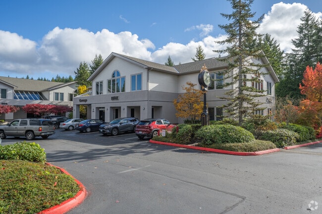
Property Record
4423 Point Fosdick Dr, Gig Harbor, WA 98335
NEARBY LISTINGS FOR SALE OR LEASE
Property Detail
4423 Point Fosdick Dr
Seattle-Tacoma-Bellevue, WA
Pierce County Short Plat No. 8112020249
022120-5010
SECTION 20 TOWNSHIP 21 RANGE 02 QUARTER 12 : L 1 SP 81-12-02-0249 EXC S 60 FT OF E 50 FT EASE OF REC OUT OF 5-003 SEG Z0101 NF RJ 33770773DC 10/13/23 KG
Officebuilding
Pierce
X
Washington
53033C1200G
1
2024
2.19 AC
2025
Gig Harbor/W Pierce Co
072408
Seattle/Puget Sound
12,131 SF
DEMOGRAPHICS near 4423 Point Fosdick Dr
1 Mile
3 Mile
5 Mile
2024 Total Population
5,326
28,920
101,227
2029 Population
5,506
29,904
104,851
Pop Growth 2024-2029
+ 3.38%
+ 3.40%
+ 3.58%
Average Age
44
46
44
2024 Total Households
2,142
11,845
42,570
HH Growth 2024-2029
+ 3.31%
+ 3.40%
+ 3.71%
Median Household Inc
$108,473
$118,328
$105,866
Avg Household Size
2.40
2.40
2.30
2024 Avg HH Vehicles
2.00
2.00
2.00
Median Home Value
$665,573
$700,843
$663,155
Median Year Built
1989
1987
1980
Nearby Places
Map Layers
Map Styles
 Street
 Aerial
- Restaurants
- Banks
- Shops
- Fitness
- Groceries
PUBLIC TRANSPORTATION
AIRPORT
Seattle-Tacoma International
DRIVE
WALK
Distance
Seattle-Tacoma International
46 min
31.4 mi
Freight Ports
Port of Tacoma
DRIVE
WALK
Distance
Port of Tacoma
19 min
12.9 mi
Nearby Properties
Address
Land Use
TOTAL SIZE
Lot Size
Zoning
Address
Land Use
TOTAL SIZE
Lot Size
Zoning
17,111 SF
647.26 AC
R1
Address
Land Use
TOTAL SIZE
Lot Size
Zoning
189,797 SF
18.06 AC
RB-2
Address
Land Use
TOTAL SIZE
Lot Size
Zoning
184,782 SF
23.38 AC
B-2
Address
Land Use
TOTAL SIZE
Lot Size
Zoning
228,761 SF
4 AC
R10
Address
Land Use
TOTAL SIZE
Lot Size
Zoning
297,754 SF
59.70 AC
PI
Address
Land Use
TOTAL SIZE
Lot Size
Zoning
166,830 SF
7.36 AC
Address
Land Use
TOTAL SIZE
Lot Size
Zoning
91,277 SF
5.08 AC
GIGH
Address
Land Use
TOTAL SIZE
Lot Size
Zoning
115,222 SF
27.53 AC
Address
Land Use
TOTAL SIZE
Lot Size
Zoning
123,138 SF
14.89 AC
RB-2
Address
Land Use
TOTAL SIZE
Lot Size
Zoning
106,293 SF
7.60 AC
Address
Land Use
TOTAL SIZE
Lot Size
Zoning
191,027 SF
11.69 AC
R4
Address
Land Use
TOTAL SIZE
Lot Size
Zoning
117,424 SF
24.84 AC
R-1
Address
Land Use
TOTAL SIZE
Lot Size
Zoning
129,455 SF
9.44 AC
RB-2
Address
Land Use
TOTAL SIZE
Lot Size
Zoning
110,156 SF
9.54 AC
B-2
Address
Land Use
TOTAL SIZE
Lot Size
Zoning
104,043 SF
1.92 AC
B-2
Address
Land Use
TOTAL SIZE
Lot Size
Zoning
114,306 SF
6.54 AC
R-3
Address
Land Use
TOTAL SIZE
Lot Size
Zoning
83,169 SF
6.66 AC
B-2
Address
Land Use
TOTAL SIZE
Lot Size
Zoning
81,328 SF
8 AC
R2
Address
Land Use
TOTAL SIZE
Lot Size
Zoning
149,856 SF
19.34 AC
R2
Address
Land Use
TOTAL SIZE
Lot Size
Zoning
67,216 SF
5.89 AC
R3
Address
Land Use
TOTAL SIZE
Lot Size
Zoning
116,103 SF
4.14 AC
R10
Address
Land Use
TOTAL SIZE
Lot Size
Zoning
132,257 SF
359.08 AC
EFRAS
Address
Land Use
TOTAL SIZE
Lot Size
Zoning
62,960 SF
5.41 AC
C-1
Address
Land Use
TOTAL SIZE
Lot Size
Zoning
77,350 SF
9.07 AC
R10
Address
Land Use
TOTAL SIZE
Lot Size
Zoning
77,906 SF
5 AC
R-1
Address
Land Use
TOTAL SIZE
Lot Size
Zoning
78,124 SF
4.65 AC
R-3
Address
Land Use
TOTAL SIZE
Lot Size
Zoning
80,000 SF
9.17 AC
R10
Address
Land Use
TOTAL SIZE
Lot Size
Zoning
105,563 SF
5.09 AC
B-2
Address
Land Use
TOTAL SIZE
Lot Size
Zoning
63,700 SF
4.73 AC
B-2
Address
Land Use
TOTAL SIZE
Lot Size
Zoning
76,925 SF
11.63 AC
PI
The World's #1 Commercial Real Estate Marketplace
Connect with us
© 2026 CoStar Group
The information above has been obtained from sources believed reliable. While we do not doubt its accuracy we have not verified it and make no guarantee, warranty or representation about it. It is your responsibility to independently confirm its accuracy and completeness. Any projections, opinions, assumptions, or estimates used are for example only and do not represent the current or future performance of the property. The value of this transaction to you depends on tax and other factors which should be evaluated by your tax, financial, and legal advisors. You and your advisors should conduct a careful, independent investigation of the property to determine to your satisfaction the suitability of the property for your needs.