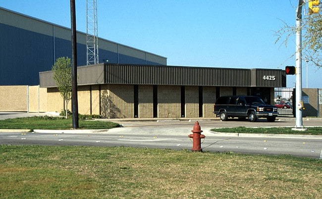
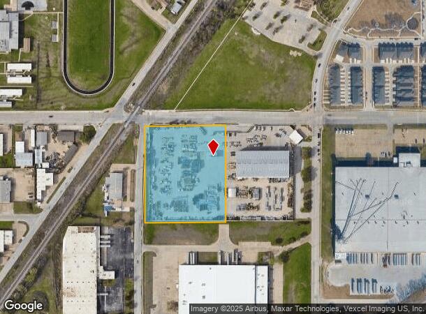
Property Record
4425 Haltom Rd, Haltom City, TX 76117
NEARBY LISTINGS FOR SALE OR LEASE
Property Detail
4425 Haltom Rd
Dallas-Fort Worth-Arlington, TX
Stanley, Green B Survey
06337481
STANLEY, GREEN B SURVEY ABSTRACT 1378 TRACT 4F1
Commercialnec
Tarrant
X
Texas
48439C0185L
4 AC
2024
Meacham Fld/Fossil Cr
2025
Dallas/Ft Worth
110204
DEMOGRAPHICS near 4425 Haltom Rd
1 Mile
3 Mile
5 Mile
2024 Total Population
12,903
101,738
271,951
2029 Population
13,500
107,038
286,442
Pop Growth 2024-2029
+ 4.63%
+ 5.21%
+ 5.33%
Average Age
36
37
37
2024 Total Households
5,267
37,747
97,540
HH Growth 2024-2029
+ 4.40%
+ 5.29%
+ 5.45%
Median Household Inc
$55,809
$62,389
$69,066
Avg Household Size
2.40
2.60
2.70
2024 Avg HH Vehicles
2.00
2.00
2.00
Median Home Value
$188,632
$212,546
$235,358
Median Year Built
1978
1982
1986
Nearby Places
Map Layers
Map Styles
 Street
 Aerial
- Restaurants
- Banks
- Shops
- Fitness
- Groceries
PUBLIC TRANSPORTATION
COMMUTER RAIL
Richland Hills (Trinity Railway Express - Dallas Area Rapid Transit (DART))
DRIVE
WALK
Distance
Richland Hills (Trinity Railway Express - Dallas Area Rapid Transit (DART))
10 min
5.3 mi
Trinity Lakes Station (TRINITY RAILWAY - Dallas Area Rapid Transit (DART))
DRIVE
WALK
Distance
Trinity Lakes Station (TRINITY RAILWAY - Dallas Area Rapid Transit (DART))
11 min
5.5 mi
AIRPORT
Dallas-Fort Worth International
DRIVE
WALK
Distance
Dallas-Fort Worth International
27 min
19.6 mi
Dallas Love Field
DRIVE
WALK
Distance
Dallas Love Field
37 min
28.3 mi
Freight Ports
Port of Shreveport
DRIVE
WALK
Distance
Port of Shreveport
248 min
227.6 mi
Nearby Properties
Address
Land Use
TOTAL SIZE
Lot Size
Zoning
Address
Land Use
TOTAL SIZE
Lot Size
Zoning
547,836 SF
2 AC
Address
Land Use
TOTAL SIZE
Lot Size
Zoning
1,440,000 SF
73.42 AC
Address
Land Use
TOTAL SIZE
Lot Size
Zoning
332,094 SF
19.33 AC
Address
Land Use
TOTAL SIZE
Lot Size
Zoning
473,562 SF
24.63 AC
Address
Land Use
TOTAL SIZE
Lot Size
Zoning
352,354 SF
17.02 AC
Address
Land Use
TOTAL SIZE
Lot Size
Zoning
381,000 SF
8.74 AC
Address
Land Use
TOTAL SIZE
Lot Size
Zoning
433,894 SF
18.99 AC
Address
Land Use
TOTAL SIZE
Lot Size
Zoning
699,246 SF
40.69 AC
Address
Land Use
TOTAL SIZE
Lot Size
Zoning
385,697 SF
15.94 AC
Address
Land Use
TOTAL SIZE
Lot Size
Zoning
810,978 SF
45.84 AC
Address
Land Use
TOTAL SIZE
Lot Size
Zoning
327,325 SF
16.87 AC
Address
Land Use
TOTAL SIZE
Lot Size
Zoning
715,000 SF
47.87 AC
Address
Land Use
TOTAL SIZE
Lot Size
Zoning
697,140 SF
37.84 AC
Address
Land Use
TOTAL SIZE
Lot Size
Zoning
344,992 SF
17.49 AC
Address
Land Use
TOTAL SIZE
Lot Size
Zoning
248,993 SF
15.40 AC
Address
Land Use
TOTAL SIZE
Lot Size
Zoning
312,219 SF
17.82 AC
Address
Land Use
TOTAL SIZE
Lot Size
Zoning
263,411 SF
7.32 AC
Address
Land Use
TOTAL SIZE
Lot Size
Zoning
368,751 SF
19.97 AC
Address
Land Use
TOTAL SIZE
Lot Size
Zoning
293,972 SF
17.30 AC
Address
Land Use
TOTAL SIZE
Lot Size
Zoning
656,390 SF
33.33 AC
Address
Land Use
TOTAL SIZE
Lot Size
Zoning
266,403 SF
16.67 AC
Address
Land Use
TOTAL SIZE
Lot Size
Zoning
270,394 SF
16.43 AC
Address
Land Use
TOTAL SIZE
Lot Size
Zoning
566,816 SF
32.79 AC
Address
Land Use
TOTAL SIZE
Lot Size
Zoning
296,724 SF
17.58 AC
Address
Land Use
TOTAL SIZE
Lot Size
Zoning
459,540 SF
36.02 AC
Address
Land Use
TOTAL SIZE
Lot Size
Zoning
588,300 SF
37.67 AC
Address
Land Use
TOTAL SIZE
Lot Size
Zoning
197,131 SF
43.78 AC
Address
Land Use
TOTAL SIZE
Lot Size
Zoning
241,064 SF
12.63 AC
Address
Land Use
TOTAL SIZE
Lot Size
Zoning
307,568 SF
13.13 AC
Address
Land Use
TOTAL SIZE
Lot Size
Zoning
540,414 SF
28.67 AC
The World's #1 Commercial Real Estate Marketplace
Connect with us
© 2025 CoStar Group
The information above has been obtained from sources believed reliable. While we do not doubt its accuracy we have not verified it and make no guarantee, warranty or representation about it. It is your responsibility to independently confirm its accuracy and completeness. Any projections, opinions, assumptions, or estimates used are for example only and do not represent the current or future performance of the property. The value of this transaction to you depends on tax and other factors which should be evaluated by your tax, financial, and legal advisors. You and your advisors should conduct a careful, independent investigation of the property to determine to your satisfaction the suitability of the property for your needs.