Property Record
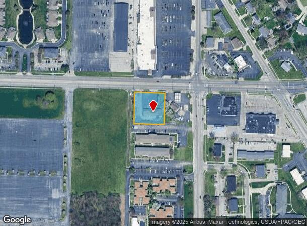
4425 Heatherdowns Blvd, Toledo, OH 43614
NEARBY LISTINGS FOR SALE OR LEASE
Property Detail
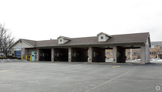
4425 Heatherdowns Blvd
21-00711
2 25 NE 1/4 W 175 FT E 380 FT N 225 FTEXC PT IN RD
Carwash
Lucas
X
Ohio
39173C0010D
0.72 AC
0
South/Southwest
2025
Toledo
007202
Toledo, OH
2,745 SF
DEMOGRAPHICS near 4425 Heatherdowns Blvd
1 Mile
3 Mile
5 Mile
2024 Total Population
9,645
64,596
161,854
2029 Population
9,416
63,619
160,218
Pop Growth 2024-2029
(2.37%)
(1.51%)
(1.01%)
Average Age
42
41
40
2024 Total Households
4,662
29,774
69,311
HH Growth 2024-2029
(2.38%)
(1.52%)
(1.05%)
Median Household Inc
$55,686
$54,857
$59,459
Avg Household Size
2.00
2.10
2.20
2024 Avg HH Vehicles
2.00
2.00
2.00
Median Home Value
$157,581
$158,158
$167,534
Median Year Built
1970
1972
1973
Nearby Places
Map Layers
Map Styles
 Street
 Aerial
- Restaurants
- Banks
- Shops
- Fitness
- Groceries
PUBLIC TRANSPORTATION
COMMUTER RAIL
DRIVE
WALK
Distance
12 min
7.1 mi
AIRPORT
Eugene F Kranz Toledo Express
DRIVE
WALK
Distance
Eugene F Kranz Toledo Express
26 min
12.1 mi
SALE & LEASE HISTORY
LISTING DATE
SALE/LEASE

Apr 10, 2023
For Sale
Nearby Properties
Address
Land Use
TOTAL SIZE
Lot Size
Zoning
Address
Land Use
TOTAL SIZE
Lot Size
Zoning
1,237,446 SF
193.94 AC
10-RS12
Address
Land Use
TOTAL SIZE
Lot Size
Zoning
123,064 SF
10 AC
10-RS6
Address
Land Use
TOTAL SIZE
Lot Size
Zoning
196,149 SF
18.69 AC
10-RD6
Address
Land Use
TOTAL SIZE
Lot Size
Zoning
170,960 SF
4 AC
10-RS6
Address
Land Use
TOTAL SIZE
Lot Size
Zoning
35.94 AC
17-C3
Address
Land Use
TOTAL SIZE
Lot Size
Zoning
3.56 AC
Address
Land Use
TOTAL SIZE
Lot Size
Zoning
211,140 SF
28.92 AC
10-IC
Address
Land Use
TOTAL SIZE
Lot Size
Zoning
269,263 SF
55.93 AC
16-R2
Address
Land Use
TOTAL SIZE
Lot Size
Zoning
94,439 SF
9 AC
10-CO
Address
Land Use
TOTAL SIZE
Lot Size
Zoning
138,607 SF
21.30 AC
10-RS12
Address
Land Use
TOTAL SIZE
Lot Size
Zoning
606,883 SF
119.87 AC
16-M2
Address
Land Use
TOTAL SIZE
Lot Size
Zoning
94,891 SF
18.80 AC
10-RS6
Address
Land Use
TOTAL SIZE
Lot Size
Zoning
352,382 SF
62.93 AC
16-M1
Address
Land Use
TOTAL SIZE
Lot Size
Zoning
337,990 SF
17.75 AC
16-M1
Address
Land Use
TOTAL SIZE
Lot Size
Zoning
8.57 AC
16-M1
Address
Land Use
TOTAL SIZE
Lot Size
Zoning
608,280 SF
48.86 AC
16-M2
Address
Land Use
TOTAL SIZE
Lot Size
Zoning
80,668 SF
9.67 AC
Address
Land Use
TOTAL SIZE
Lot Size
Zoning
139,741 SF
30.48 AC
19-RA3
Address
Land Use
TOTAL SIZE
Lot Size
Zoning
214,986 SF
17.55 AC
19-R1
Address
Land Use
TOTAL SIZE
Lot Size
Zoning
119.87 AC
16-M2
Address
Land Use
TOTAL SIZE
Lot Size
Zoning
81,672 SF
14.93 AC
10-RS9
Address
Land Use
TOTAL SIZE
Lot Size
Zoning
210,996 SF
22.18 AC
10-CRSO
Address
Land Use
TOTAL SIZE
Lot Size
Zoning
111,195 SF
13.64 AC
19-C2
Address
Land Use
TOTAL SIZE
Lot Size
Zoning
78,166 SF
2.08 AC
16-CM
Address
Land Use
TOTAL SIZE
Lot Size
Zoning
131,201 SF
10 AC
10-CUP
Address
Land Use
TOTAL SIZE
Lot Size
Zoning
104,314 SF
15.43 AC
16-M2
Address
Land Use
TOTAL SIZE
Lot Size
Zoning
363,176 SF
11.72 AC
10-RM36
Address
Land Use
TOTAL SIZE
Lot Size
Zoning
126,732 SF
15 AC
10-CRSO
Address
Land Use
TOTAL SIZE
Lot Size
Zoning
48,321 SF
93.94 AC
10-RS12
Address
Land Use
TOTAL SIZE
Lot Size
Zoning
58.33 AC
10-IL
The World's #1 Commercial Real Estate Marketplace
Connect with us
© 2026 CoStar Group
The information above has been obtained from sources believed reliable. While we do not doubt its accuracy we have not verified it and make no guarantee, warranty or representation about it. It is your responsibility to independently confirm its accuracy and completeness. Any projections, opinions, assumptions, or estimates used are for example only and do not represent the current or future performance of the property. The value of this transaction to you depends on tax and other factors which should be evaluated by your tax, financial, and legal advisors. You and your advisors should conduct a careful, independent investigation of the property to determine to your satisfaction the suitability of the property for your needs.