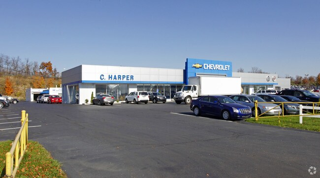
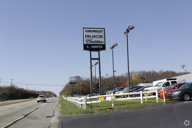
Property Record
4427 State Route 51, Rostraver Township, PA 15012

NEARBY LISTINGS FOR SALE OR LEASE
Property Detail
4427 State Route 51
56-09-00-0-141
BLDGS, PAV
Commercialnec
Westmoreland
X
Pennsylvania
42051C0045E
12.28 AC
2025
Westmoreland County
2025
Pittsburgh
805904
Pittsburgh, PA
55,499 SF
DEMOGRAPHICS near 4427 State Route 51
1 Mile
3 Mile
5 Mile
2024 Total Population
1,630
9,040
33,615
2029 Population
1,651
9,000
33,643
Pop Growth 2024-2029
+ 1.29%
(0.44%)
+ 0.08%
Average Age
44
45
44
2024 Total Households
689
3,723
14,792
HH Growth 2024-2029
+ 1.31%
(0.46%)
+ 0.05%
Median Household Inc
$80,462
$84,836
$55,664
Avg Household Size
2.30
2.40
2.20
2024 Avg HH Vehicles
2.00
2.00
2.00
Median Home Value
$206,959
$218,204
$142,518
Median Year Built
1994
1973
1957
Nearby Places
Map Layers
Map Styles
 Street
 Aerial
- Restaurants
- Banks
- Shops
- Fitness
- Groceries
PUBLIC TRANSPORTATION
AIRPORT
Arnold Palmer Regional
DRIVE
WALK
Distance
Arnold Palmer Regional
51 min
31.3 mi
Pittsburgh International
DRIVE
WALK
Distance
Pittsburgh International
68 min
39.8 mi
Nearby Properties
Address
Land Use
TOTAL SIZE
Lot Size
Zoning
Address
Land Use
TOTAL SIZE
Lot Size
Zoning
Address
Land Use
TOTAL SIZE
Lot Size
Zoning
379,520 SF
50 AC
Address
Land Use
TOTAL SIZE
Lot Size
Zoning
203,880 SF
29.80 AC
Address
Land Use
TOTAL SIZE
Lot Size
Zoning
Address
Land Use
TOTAL SIZE
Lot Size
Zoning
87,169 SF
8.54 AC
Address
Land Use
TOTAL SIZE
Lot Size
Zoning
14.07 AC
Address
Land Use
TOTAL SIZE
Lot Size
Zoning
45,462 SF
10.80 AC
Address
Land Use
TOTAL SIZE
Lot Size
Zoning
Address
Land Use
TOTAL SIZE
Lot Size
Zoning
19.92 AC
Address
Land Use
TOTAL SIZE
Lot Size
Zoning
37,224 SF
90.07 AC
Address
Land Use
TOTAL SIZE
Lot Size
Zoning
Address
Land Use
TOTAL SIZE
Lot Size
Zoning
249.60 AC
Address
Land Use
TOTAL SIZE
Lot Size
Zoning
192.90 AC
Address
Land Use
TOTAL SIZE
Lot Size
Zoning
86.90 AC
Address
Land Use
TOTAL SIZE
Lot Size
Zoning
46,978 SF
13.10 AC
Address
Land Use
TOTAL SIZE
Lot Size
Zoning
Address
Land Use
TOTAL SIZE
Lot Size
Zoning
Address
Land Use
TOTAL SIZE
Lot Size
Zoning
12,621 SF
32.40 AC
Address
Land Use
TOTAL SIZE
Lot Size
Zoning
Address
Land Use
TOTAL SIZE
Lot Size
Zoning
7,670 SF
10.45 AC
Address
Land Use
TOTAL SIZE
Lot Size
Zoning
27,076 SF
22.24 AC
Address
Land Use
TOTAL SIZE
Lot Size
Zoning
Address
Land Use
TOTAL SIZE
Lot Size
Zoning
Address
Land Use
TOTAL SIZE
Lot Size
Zoning
15,870 SF
1.91 AC
Address
Land Use
TOTAL SIZE
Lot Size
Zoning
Address
Land Use
TOTAL SIZE
Lot Size
Zoning
1.61 AC
Address
Land Use
TOTAL SIZE
Lot Size
Zoning
10.22 AC
Address
Land Use
TOTAL SIZE
Lot Size
Zoning
11,795 SF
10 AC
Address
Land Use
TOTAL SIZE
Lot Size
Zoning
The World's #1 Commercial Real Estate Marketplace
Connect with us
© 2026 CoStar Group
The information above has been obtained from sources believed reliable. While we do not doubt its accuracy we have not verified it and make no guarantee, warranty or representation about it. It is your responsibility to independently confirm its accuracy and completeness. Any projections, opinions, assumptions, or estimates used are for example only and do not represent the current or future performance of the property. The value of this transaction to you depends on tax and other factors which should be evaluated by your tax, financial, and legal advisors. You and your advisors should conduct a careful, independent investigation of the property to determine to your satisfaction the suitability of the property for your needs.