Property Record
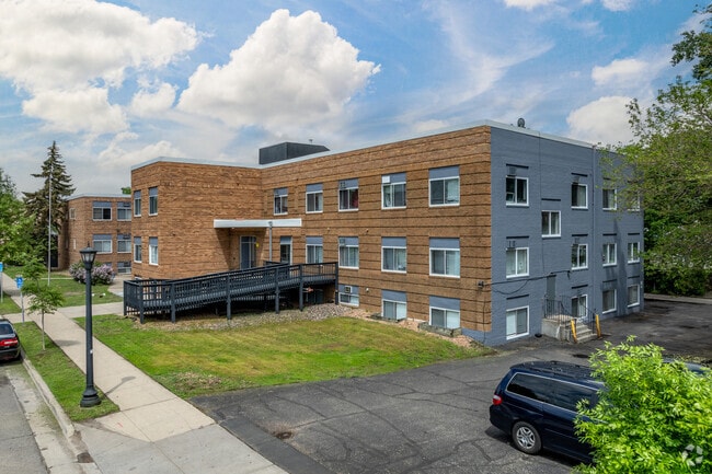
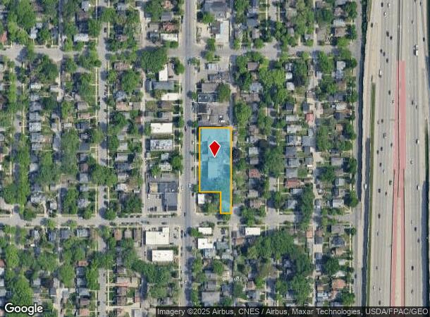
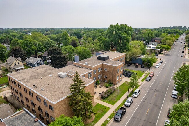
4429 Nicollet Ave, Minneapolis, MN 55419
NEARBY LISTINGS FOR SALE OR LEASE
Property Detail
4429 Nicollet Ave
Minneapolis-St. Paul-Bloomington, MN-WI
Turner & Warnocks 1St Addn To Mpls
10-028-24-43-0167
LOT 008 BLOCK 002 A TURNER & WARNOCKS 1ST ADDN TO MPLS LOT 8 BLOCK 2 ALSO THE E 42 FT OF LOTS 8 AND 9 BLOCK 3 AND ALL OF LOTS 10 THROUGH 14 INCLUSIVE IN SAID BLOCK IRREGULAR
Apartment
Hennepin
X
Minnesota
27053C0367F
8
2024
0.81 AC
2024
Kingfield
110800
Minneapolis/St Paul
24,170 SF
DEMOGRAPHICS near 4429 Nicollet Ave
1 Mile
3 Mile
5 Mile
2024 Total Population
22,173
209,032
471,660
2029 Population
21,530
205,349
465,065
Pop Growth 2024-2029
(2.90%)
(1.76%)
(1.40%)
Average Age
39
38
38
2024 Total Households
8,893
91,301
212,386
HH Growth 2024-2029
(3.10%)
(1.79%)
(1.33%)
Median Household Inc
$106,767
$79,914
$75,394
Avg Household Size
2.40
2.20
2.10
2024 Avg HH Vehicles
2.00
2.00
1.00
Median Home Value
$372,874
$363,774
$364,797
Median Year Built
1945
1948
1958
Nearby Places
Map Layers
Map Styles
 Street
 Aerial
- Restaurants
- Banks
- Shops
- Fitness
- Groceries
PUBLIC TRANSPORTATION
COMMUTER RAIL
Target Field Station (Northstar Corridor - Northstar Commuter Rail)
DRIVE
WALK
Distance
Target Field Station (Northstar Corridor - Northstar Commuter Rail)
11 min
5.4 mi
AIRPORT
Minneapolis-St Paul International/Wold-Chamberlain
DRIVE
WALK
Distance
Minneapolis-St Paul International/Wold-Chamberlain
17 min
8.9 mi
Freight Ports
Port Milwaukee
DRIVE
WALK
Distance
Port Milwaukee
380 min
341.8 mi
SALE & LEASE HISTORY
LISTING DATE
SALE/LEASE

May 31, 2023
For Sale
May 05, 2019
For Sale
Feb 19, 2025
For Sale
Nearby Properties
Address
Land Use
TOTAL SIZE
Lot Size
Zoning
Address
Land Use
TOTAL SIZE
Lot Size
Zoning
275,782 SF
2.40 AC
C3A
Address
Land Use
TOTAL SIZE
Lot Size
Zoning
659,076 SF
1.45 AC
C3A
Address
Land Use
TOTAL SIZE
Lot Size
Zoning
1.50 AC
Address
Land Use
TOTAL SIZE
Lot Size
Zoning
264,176 SF
1.61 AC
OR2
Address
Land Use
TOTAL SIZE
Lot Size
Zoning
233,886 SF
1.63 AC
R5
Address
Land Use
TOTAL SIZE
Lot Size
Zoning
239,539 SF
1.29 AC
OR2
Address
Land Use
TOTAL SIZE
Lot Size
Zoning
295,036 SF
1.82 AC
R6
Address
Land Use
TOTAL SIZE
Lot Size
Zoning
424,327 SF
2.16 AC
Address
Land Use
TOTAL SIZE
Lot Size
Zoning
346,787 SF
1.94 AC
R3
Address
Land Use
TOTAL SIZE
Lot Size
Zoning
186,691 SF
0.80 AC
C3A
Address
Land Use
TOTAL SIZE
Lot Size
Zoning
263,948 SF
2.73 AC
R6
Address
Land Use
TOTAL SIZE
Lot Size
Zoning
160,202 SF
0.74 AC
C3A
Address
Land Use
TOTAL SIZE
Lot Size
Zoning
179,243 SF
1.05 AC
C2
Address
Land Use
TOTAL SIZE
Lot Size
Zoning
186,761 SF
1.14 AC
C3A
Address
Land Use
TOTAL SIZE
Lot Size
Zoning
2.01 AC
Address
Land Use
TOTAL SIZE
Lot Size
Zoning
283,912 SF
2.17 AC
R6
Address
Land Use
TOTAL SIZE
Lot Size
Zoning
307,923 SF
1.33 AC
R5
Address
Land Use
TOTAL SIZE
Lot Size
Zoning
184,111 SF
0.29 AC
C3A
Address
Land Use
TOTAL SIZE
Lot Size
Zoning
170,290 SF
2.28 AC
OR2
Address
Land Use
TOTAL SIZE
Lot Size
Zoning
229,198 SF
1.39 AC
R3
Address
Land Use
TOTAL SIZE
Lot Size
Zoning
164,639 SF
0.96 AC
C3S
Address
Land Use
TOTAL SIZE
Lot Size
Zoning
Address
Land Use
TOTAL SIZE
Lot Size
Zoning
186,059 SF
0.64 AC
C3A
Address
Land Use
TOTAL SIZE
Lot Size
Zoning
186,322 SF
4.81 AC
OR2
Address
Land Use
TOTAL SIZE
Lot Size
Zoning
219,788 SF
0.90 AC
C3A
Address
Land Use
TOTAL SIZE
Lot Size
Zoning
170,866 SF
4.44 AC
R6
Address
Land Use
TOTAL SIZE
Lot Size
Zoning
Address
Land Use
TOTAL SIZE
Lot Size
Zoning
Address
Land Use
TOTAL SIZE
Lot Size
Zoning
254,517 SF
2.22 AC
C3A
Address
Land Use
TOTAL SIZE
Lot Size
Zoning
The World's #1 Commercial Real Estate Marketplace
Connect with us
© 2026 CoStar Group
The information above has been obtained from sources believed reliable. While we do not doubt its accuracy we have not verified it and make no guarantee, warranty or representation about it. It is your responsibility to independently confirm its accuracy and completeness. Any projections, opinions, assumptions, or estimates used are for example only and do not represent the current or future performance of the property. The value of this transaction to you depends on tax and other factors which should be evaluated by your tax, financial, and legal advisors. You and your advisors should conduct a careful, independent investigation of the property to determine to your satisfaction the suitability of the property for your needs.