Property Record
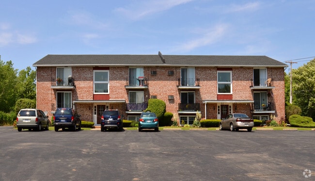
443 Davison Rd, Lockport, NY 14094


Property Detail
443 Davison Rd
290900-109-020-0001-028-000
DAVISON RD 443-501 DAVISON RD
Apartment
NIAGARA
R3
New York
AE The base floodplain where base flood elevations are provided. AE Zones are now used on new format FIRMs instead of A1-A30 Zones.
28.000
2025
4.22 AC
2025
Outlying Niagara County
023902
Buffalo/Niagara Falls
8,160 SF
Buffalo-Cheektowaga, NY
NEARBY LISTINGS FOR SALE OR LEASE
DEMOGRAPHICS near 443 Davison Rd
1 mile
3 mile
5 mile
2025 Total Population
9,114
32,658
43,345
2030 Population
8,961
32,301
42,913
Pop Growth 2025-2030
(1.68%)
(1.09%)
(1.00%)
Average Age
43
42
42
2025 Total Households
4,109
14,496
18,750
HH Growth 2025-2030
(1.68%)
(1.08%)
(0.99%)
Median Household Inc
$68,710
$65,937
$68,337
Avg Household Size
2.20
2.20
2.30
2025 Avg HH Vehicles
2.00
2.00
2.00
Median Home Value
$169,126
$162,634
$176,246
Median Year Built
1960
1960
1967
Nearby Places
Map Layers
Map Styles
 Street
 Aerial
Layers
 Traffic
 Biking
Places
Listings with unknown addresses are not visible on the map
- Restaurants
- Banks
- Shops
- Fitness
- Groceries
PUBLIC TRANSPORTATION
AIRPORT
Niagara Falls International
Drive
Walk
Distance
Niagara Falls International
27 min
17.9 mi
Buffalo Niagara International
Drive
Walk
Distance
Buffalo Niagara International
28 min
18.8 mi
Freight Ports
Albany, NY Port
Drive
Walk
Distance
Albany, NY Port
341 min
286.5 mi
Nearby Properties
Address
Land Use
TOTAL SIZE
Lot Size
Zoning
Address
Land Use
TOTAL SIZE
Lot Size
Zoning
Address
Land Use
TOTAL SIZE
Lot Size
Zoning
90,347 SF
18.66 AC
B-2
Address
Land Use
TOTAL SIZE
Lot Size
Zoning
65,184 SF
100.76 AC
B-2
Address
Land Use
TOTAL SIZE
Lot Size
Zoning
90.60 AC
AR
Address
Land Use
TOTAL SIZE
Lot Size
Zoning
259,393 SF
33.74 AC
RA
Address
Land Use
TOTAL SIZE
Lot Size
Zoning
516 SF
53.70 AC
Address
Land Use
TOTAL SIZE
Lot Size
Zoning
4,417 SF
61.30 AC
Address
Land Use
TOTAL SIZE
Lot Size
Zoning
206,149 SF
17.86 AC
B-2
Address
Land Use
TOTAL SIZE
Lot Size
Zoning
660 SF
0.99 AC
R3
Address
Land Use
TOTAL SIZE
Lot Size
Zoning
8,604 SF
15 AC
R-2
Address
Land Use
TOTAL SIZE
Lot Size
Zoning
119,070 SF
21.99 AC
RA
Address
Land Use
TOTAL SIZE
Lot Size
Zoning
111,617 SF
16.83 AC
RA
Address
Land Use
TOTAL SIZE
Lot Size
Zoning
130,160 SF
13 AC
B-2
Address
Land Use
TOTAL SIZE
Lot Size
Zoning
108,630 SF
0.77 AC
B2
Address
Land Use
TOTAL SIZE
Lot Size
Zoning
760 SF
7.82 AC
R1
Address
Land Use
TOTAL SIZE
Lot Size
Zoning
67,111 SF
3.22 AC
B2
Address
Land Use
TOTAL SIZE
Lot Size
Zoning
25,758 SF
4.06 AC
B3
Address
Land Use
TOTAL SIZE
Lot Size
Zoning
115,228 SF
10.90 AC
Address
Land Use
TOTAL SIZE
Lot Size
Zoning
24,103 SF
74.12 AC
Address
Land Use
TOTAL SIZE
Lot Size
Zoning
Address
Land Use
TOTAL SIZE
Lot Size
Zoning
140,048 SF
13.60 AC
B-2
Address
Land Use
TOTAL SIZE
Lot Size
Zoning
16,282 SF
4.90 AC
R3
Address
Land Use
TOTAL SIZE
Lot Size
Zoning
62,310 SF
6.39 AC
R3
Address
Land Use
TOTAL SIZE
Lot Size
Zoning
31.67 AC
AG
Address
Land Use
TOTAL SIZE
Lot Size
Zoning
46,341 SF
5.33 AC
R1
Address
Land Use
TOTAL SIZE
Lot Size
Zoning
7,692 SF
3.82 AC
R3
Address
Land Use
TOTAL SIZE
Lot Size
Zoning
27.12 AC
Address
Land Use
TOTAL SIZE
Lot Size
Zoning
23,904 SF
2 AC
Address
Land Use
TOTAL SIZE
Lot Size
Zoning
157,785 SF
7.32 AC
I3
Address
Land Use
TOTAL SIZE
Lot Size
Zoning
52,000 SF
30.40 AC
R-1
The World's #1 Commercial Real Estate Marketplace
Connect with us
© 2026 CoStar Group
The information above has been obtained from sources believed reliable. While we do not doubt its accuracy we have not verified it and make no guarantee, warranty or representation about it. It is your responsibility to independently confirm its accuracy and completeness. Any projections, opinions, assumptions, or estimates used are for example only and do not represent the current or future performance of the property. The value of this transaction to you depends on tax and other factors which should be evaluated by your tax, financial, and legal advisors. You and your advisors should conduct a careful, independent investigation of the property to determine to your satisfaction the suitability of the property for your needs.