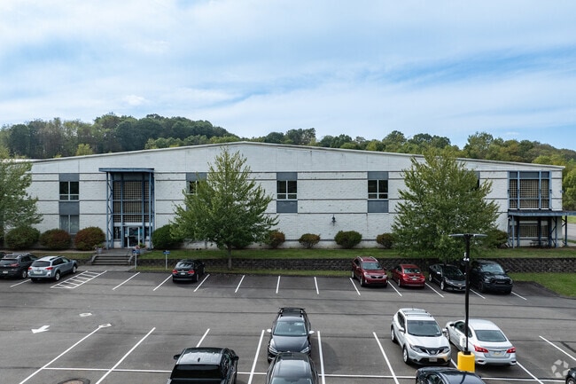
Property Record
4430 Gibsonia Rd, Gibsonia, PA 15044
NEARBY LISTINGS FOR SALE OR LEASE
Property Detail
4430 Gibsonia Rd
Pittsburgh, PA
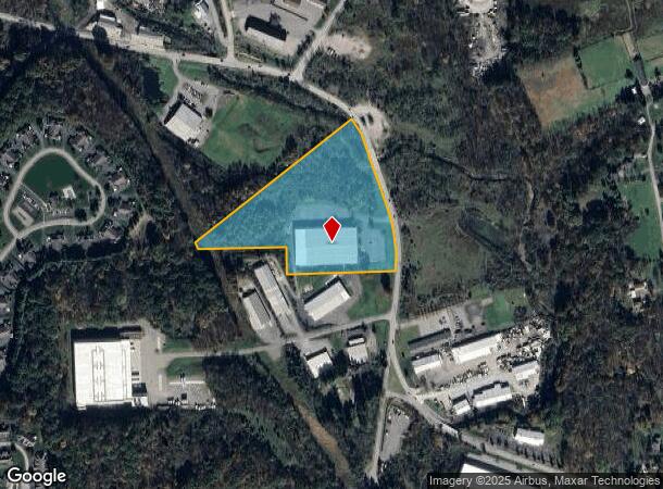
Frontier Drive Plan
1357-D-00325-0000-00
FRONTIER DRIVE PLAN PT LOT 602-R = 137.99 FRONTING WITH 16 TOTAL BEARINGS
Industrialgeneral
Allegheny
AE
Pennsylvania
42003C0207H
325
2024
12.31 AC
2025
Northeast Pittsburgh
407002
Pittsburgh
DEMOGRAPHICS near 4430 Gibsonia Rd
1 Mile
3 Mile
5 Mile
2024 Total Population
2,151
21,216
47,010
2029 Population
2,089
20,561
45,749
Pop Growth 2024-2029
(2.88%)
(3.09%)
(2.68%)
Average Age
48
44
44
2024 Total Households
889
8,256
18,364
HH Growth 2024-2029
(2.92%)
(3.13%)
(2.72%)
Median Household Inc
$101,786
$108,310
$107,649
Avg Household Size
2.30
2.50
2.50
2024 Avg HH Vehicles
2.00
2.00
2.00
Median Home Value
$251,219
$287,665
$305,437
Median Year Built
1981
1979
1977
Nearby Places
Map Layers
Map Styles
 Street
 Aerial
- Restaurants
- Banks
- Shops
- Fitness
- Groceries
PUBLIC TRANSPORTATION
AIRPORT
Pittsburgh International
DRIVE
WALK
Distance
Pittsburgh International
53 min
26.8 mi
Arnold Palmer Regional
DRIVE
WALK
Distance
Arnold Palmer Regional
69 min
46.3 mi
Nearby Properties
Address
Land Use
TOTAL SIZE
Lot Size
Zoning
Address
Land Use
TOTAL SIZE
Lot Size
Zoning
115.10 AC
Address
Land Use
TOTAL SIZE
Lot Size
Zoning
44.80 AC
Address
Land Use
TOTAL SIZE
Lot Size
Zoning
4,227 SF
23.34 AC
Address
Land Use
TOTAL SIZE
Lot Size
Zoning
28.38 AC
Address
Land Use
TOTAL SIZE
Lot Size
Zoning
Address
Land Use
TOTAL SIZE
Lot Size
Zoning
43.18 AC
Address
Land Use
TOTAL SIZE
Lot Size
Zoning
121.54 AC
Address
Land Use
TOTAL SIZE
Lot Size
Zoning
Address
Land Use
TOTAL SIZE
Lot Size
Zoning
Address
Land Use
TOTAL SIZE
Lot Size
Zoning
12.25 AC
Address
Land Use
TOTAL SIZE
Lot Size
Zoning
1,465 SF
11.68 AC
Address
Land Use
TOTAL SIZE
Lot Size
Zoning
13.17 AC
Address
Land Use
TOTAL SIZE
Lot Size
Zoning
1,426 SF
16.11 AC
Address
Land Use
TOTAL SIZE
Lot Size
Zoning
9.70 AC
Address
Land Use
TOTAL SIZE
Lot Size
Zoning
8.23 AC
Address
Land Use
TOTAL SIZE
Lot Size
Zoning
4,434 SF
11.82 AC
Address
Land Use
TOTAL SIZE
Lot Size
Zoning
Address
Land Use
TOTAL SIZE
Lot Size
Zoning
6.67 AC
Address
Land Use
TOTAL SIZE
Lot Size
Zoning
14.55 AC
Address
Land Use
TOTAL SIZE
Lot Size
Zoning
41.36 AC
Address
Land Use
TOTAL SIZE
Lot Size
Zoning
21.70 AC
Address
Land Use
TOTAL SIZE
Lot Size
Zoning
Address
Land Use
TOTAL SIZE
Lot Size
Zoning
Address
Land Use
TOTAL SIZE
Lot Size
Zoning
Address
Land Use
TOTAL SIZE
Lot Size
Zoning
Address
Land Use
TOTAL SIZE
Lot Size
Zoning
57.32 AC
Address
Land Use
TOTAL SIZE
Lot Size
Zoning
Address
Land Use
TOTAL SIZE
Lot Size
Zoning
13.95 AC
Address
Land Use
TOTAL SIZE
Lot Size
Zoning
The World's #1 Commercial Real Estate Marketplace
Connect with us
© 2025 CoStar Group
The information above has been obtained from sources believed reliable. While we do not doubt its accuracy we have not verified it and make no guarantee, warranty or representation about it. It is your responsibility to independently confirm its accuracy and completeness. Any projections, opinions, assumptions, or estimates used are for example only and do not represent the current or future performance of the property. The value of this transaction to you depends on tax and other factors which should be evaluated by your tax, financial, and legal advisors. You and your advisors should conduct a careful, independent investigation of the property to determine to your satisfaction the suitability of the property for your needs.