Property Record
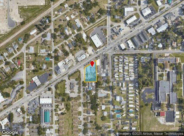
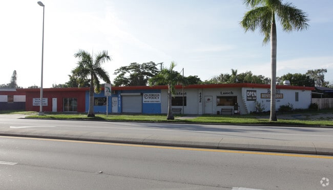
4432 Palm Beach Blvd, Fort Myers, FL 33905

NEARBY LISTINGS FOR SALE OR LEASE
Property Detail
4432 Palm Beach Blvd
09-44-25-00-00001.0000
Palm Beach - Ortiz To Tarpon
Storemultistory
W 1/2 OF E 1/2 OF W 1/2 OF NW 1/4 OF NW 1/4 S OF BLVD LESS S 975 FT
X
Lee
12071C0287G
Florida
2024
0.66 AC
2025
City of Ft Myers
040123
Southwest Florida
8,326 SF
Cape Coral-Fort Myers, FL
DEMOGRAPHICS near 4432 Palm Beach Blvd
1 Mile
3 Mile
5 Mile
2024 Total Population
10,813
42,532
107,203
2029 Population
12,740
50,456
127,596
Pop Growth 2024-2029
+ 17.82%
+ 18.63%
+ 19.02%
Average Age
33
41
42
2024 Total Households
3,113
15,894
43,765
HH Growth 2024-2029
+ 17.44%
+ 18.60%
+ 18.89%
Median Household Inc
$38,270
$43,007
$45,237
Avg Household Size
3.10
2.40
2.30
2024 Avg HH Vehicles
1.00
1.00
1.00
Median Home Value
$140,709
$147,418
$190,286
Median Year Built
1971
1981
1987
Nearby Places
Map Layers
Map Styles
 Street
 Aerial
- Restaurants
- Banks
- Shops
- Fitness
- Groceries
PUBLIC TRANSPORTATION
AIRPORT
Southwest Florida International
DRIVE
WALK
Distance
Southwest Florida International
21 min
14.7 mi
Punta Gorda
DRIVE
WALK
Distance
Punta Gorda
29 min
23.6 mi
Freight Ports
Port Manatee
DRIVE
WALK
Distance
Port Manatee
109 min
95.3 mi
SALE & LEASE HISTORY
LISTING DATE
SALE/LEASE

Nov 03, 2016
For Sale
Nearby Properties
Address
Land Use
TOTAL SIZE
Lot Size
Zoning
Address
Land Use
TOTAL SIZE
Lot Size
Zoning
77.79 AC
PUD
Address
Land Use
TOTAL SIZE
Lot Size
Zoning
438,839 SF
66.95 AC
MU
Address
Land Use
TOTAL SIZE
Lot Size
Zoning
475,045 SF
30.22 AC
PUD
Address
Land Use
TOTAL SIZE
Lot Size
Zoning
723,322 SF
1.73 AC
PUD
Address
Land Use
TOTAL SIZE
Lot Size
Zoning
98,242 SF
17.43 AC
RS-7
Address
Land Use
TOTAL SIZE
Lot Size
Zoning
580,121 SF
61.83 AC
IL
Address
Land Use
TOTAL SIZE
Lot Size
Zoning
376,949 SF
49.70 AC
RM16
Address
Land Use
TOTAL SIZE
Lot Size
Zoning
319,765 SF
47.40 AC
RS7
Address
Land Use
TOTAL SIZE
Lot Size
Zoning
106,300 SF
14.71 AC
TFC2
Address
Land Use
TOTAL SIZE
Lot Size
Zoning
231,360 SF
17.08 AC
PUD
Address
Land Use
TOTAL SIZE
Lot Size
Zoning
11,062 SF
47.11 AC
Address
Land Use
TOTAL SIZE
Lot Size
Zoning
291,613 SF
40.32 AC
RPD
Address
Land Use
TOTAL SIZE
Lot Size
Zoning
103,525 SF
236.09 AC
IL
Address
Land Use
TOTAL SIZE
Lot Size
Zoning
137,687 SF
18.25 AC
RS7
Address
Land Use
TOTAL SIZE
Lot Size
Zoning
73,644 SF
34.16 AC
AG-2
Address
Land Use
TOTAL SIZE
Lot Size
Zoning
8,811 SF
11.79 AC
PUD
Address
Land Use
TOTAL SIZE
Lot Size
Zoning
78,179 SF
34.82 AC
PUD
Address
Land Use
TOTAL SIZE
Lot Size
Zoning
199,728 SF
19.76 AC
CC
Address
Land Use
TOTAL SIZE
Lot Size
Zoning
5.88 AC
CG
Address
Land Use
TOTAL SIZE
Lot Size
Zoning
548,993 SF
54.61 AC
RM16
Address
Land Use
TOTAL SIZE
Lot Size
Zoning
127,525 SF
12.90 AC
RS6
Address
Land Use
TOTAL SIZE
Lot Size
Zoning
105,201 SF
10.47 AC
RM12
Address
Land Use
TOTAL SIZE
Lot Size
Zoning
87,353 SF
3.70 AC
SDA
Address
Land Use
TOTAL SIZE
Lot Size
Zoning
30,708 SF
9.33 AC
CPD
Address
Land Use
TOTAL SIZE
Lot Size
Zoning
99,339 SF
1.97 AC
C1
Address
Land Use
TOTAL SIZE
Lot Size
Zoning
85,915 SF
9.33 AC
CC
Address
Land Use
TOTAL SIZE
Lot Size
Zoning
91,107 SF
35.31 AC
REC
Address
Land Use
TOTAL SIZE
Lot Size
Zoning
67,403 SF
11.78 AC
CPD
Address
Land Use
TOTAL SIZE
Lot Size
Zoning
66,312 SF
14.22 AC
AG-2
Address
Land Use
TOTAL SIZE
Lot Size
Zoning
374,671 SF
49.33 AC
IL
The World's #1 Commercial Real Estate Marketplace
Connect with us
© 2025 CoStar Group
The information above has been obtained from sources believed reliable. While we do not doubt its accuracy we have not verified it and make no guarantee, warranty or representation about it. It is your responsibility to independently confirm its accuracy and completeness. Any projections, opinions, assumptions, or estimates used are for example only and do not represent the current or future performance of the property. The value of this transaction to you depends on tax and other factors which should be evaluated by your tax, financial, and legal advisors. You and your advisors should conduct a careful, independent investigation of the property to determine to your satisfaction the suitability of the property for your needs.