Property Record
4437 Mahrt Ave Se, Salem, OR 97317


NEARBY LISTINGS FOR SALE OR LEASE
Property Detail
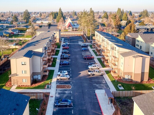
4437 Mahrt Ave Se
Portland
Shepherds Crossing
Salem, OR
SHEPHERDS CROSSING LOT 1 ACRES 1.81
600652
Marion
Multifamilydwelling
Oregon
2024
1
2025
1.81 AC
001801
Four Corners
34,260 SF
DEMOGRAPHICS near 4437 Mahrt Ave Se
1 Mile
3 Mile
5 Mile
2024 Total Population
17,712
80,586
193,725
2029 Population
17,988
81,700
196,881
Pop Growth 2024-2029
+ 1.56%
+ 1.38%
+ 1.63%
Average Age
37
38
38
2024 Total Households
6,065
27,345
69,334
HH Growth 2024-2029
+ 1.62%
+ 1.45%
+ 1.74%
Median Household Inc
$60,259
$54,991
$60,119
Avg Household Size
2.90
2.70
2.60
2024 Avg HH Vehicles
2.00
2.00
2.00
Median Home Value
$258,378
$276,761
$327,539
Median Year Built
1978
1975
1976
Nearby Places
Map Layers
Map Styles
 Street
 Aerial
- Restaurants
- Banks
- Shops
- Fitness
- Groceries
PUBLIC TRANSPORTATION
COMMUTER RAIL
Salem (Amtrak Cascades - Amtrak, Coast Starlight - Amtrak)
DRIVE
WALK
Distance
Salem (Amtrak Cascades - Amtrak, Coast Starlight - Amtrak)
8 min
3.9 mi
Freight Ports
Port of Portland
DRIVE
WALK
Distance
Port of Portland
67 min
50.2 mi
SALE & LEASE HISTORY
LISTING DATE
SALE/LEASE

Nov 09, 2022
For Sale
Nearby Properties
Address
Land Use
TOTAL SIZE
Lot Size
Zoning
Address
Land Use
TOTAL SIZE
Lot Size
Zoning
978,999 SF
25.74 AC
PE
Address
Land Use
TOTAL SIZE
Lot Size
Zoning
236,837 SF
20.76 AC
PE
Address
Land Use
TOTAL SIZE
Lot Size
Zoning
1,018,020 SF
61.75 AC
EC
Address
Land Use
TOTAL SIZE
Lot Size
Zoning
257,350 SF
19.78 AC
PH
Address
Land Use
TOTAL SIZE
Lot Size
Zoning
532,684 SF
158.53 AC
PA
Address
Land Use
TOTAL SIZE
Lot Size
Zoning
145,520 SF
1.70 AC
PM
Address
Land Use
TOTAL SIZE
Lot Size
Zoning
466,506 SF
52.60 AC
EC
Address
Land Use
TOTAL SIZE
Lot Size
Zoning
412,248 SF
27.80 AC
Address
Land Use
TOTAL SIZE
Lot Size
Zoning
166,344 SF
1.70 AC
PM
Address
Land Use
TOTAL SIZE
Lot Size
Zoning
264,504 SF
28.17 AC
PS
Address
Land Use
TOTAL SIZE
Lot Size
Zoning
393,453 SF
24.18 AC
CR
Address
Land Use
TOTAL SIZE
Lot Size
Zoning
Address
Land Use
TOTAL SIZE
Lot Size
Zoning
341,320 SF
17.85 AC
PH
Address
Land Use
TOTAL SIZE
Lot Size
Zoning
137,002 SF
6.27 AC
PE
Address
Land Use
TOTAL SIZE
Lot Size
Zoning
33,560 SF
4.95 AC
CR
Address
Land Use
TOTAL SIZE
Lot Size
Zoning
152,237 SF
8.16 AC
RM2; RM1
Address
Land Use
TOTAL SIZE
Lot Size
Zoning
77,198 SF
1.71 AC
PM
Address
Land Use
TOTAL SIZE
Lot Size
Zoning
209,780 SF
19.85 AC
IC
Address
Land Use
TOTAL SIZE
Lot Size
Zoning
193,237 SF
9.98 AC
IG
Address
Land Use
TOTAL SIZE
Lot Size
Zoning
253,189 SF
12.83 AC
RM2
Address
Land Use
TOTAL SIZE
Lot Size
Zoning
105,152 SF
2.39 AC
CR
Address
Land Use
TOTAL SIZE
Lot Size
Zoning
171,702 SF
16.02 AC
CR
Address
Land Use
TOTAL SIZE
Lot Size
Zoning
115,561 SF
26.70 AC
PE; RA
Address
Land Use
TOTAL SIZE
Lot Size
Zoning
25.68 AC
IG
Address
Land Use
TOTAL SIZE
Lot Size
Zoning
108,723 SF
7.12 AC
IC
Address
Land Use
TOTAL SIZE
Lot Size
Zoning
129,850 SF
19.66 AC
IBC
Address
Land Use
TOTAL SIZE
Lot Size
Zoning
85,536 SF
10.25 AC
PS
Address
Land Use
TOTAL SIZE
Lot Size
Zoning
The World's #1 Commercial Real Estate Marketplace
Connect with us
© 2025 CoStar Group
The information above has been obtained from sources believed reliable. While we do not doubt its accuracy we have not verified it and make no guarantee, warranty or representation about it. It is your responsibility to independently confirm its accuracy and completeness. Any projections, opinions, assumptions, or estimates used are for example only and do not represent the current or future performance of the property. The value of this transaction to you depends on tax and other factors which should be evaluated by your tax, financial, and legal advisors. You and your advisors should conduct a careful, independent investigation of the property to determine to your satisfaction the suitability of the property for your needs.