Property Record
4434 State Route 133, Batavia, OH 45103
NEARBY LISTINGS FOR SALE OR LEASE
Property Detail
4434 State Route 133
Cincinnati, OH-KY-IN
Wallace Military Survey No 955
52-35-07C-034
05TY FROM 003.
Agriculturalland
Clermont
X
Ohio
39015C0125D
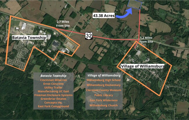
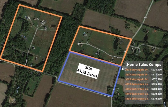
43.38 AC
2024
Outlying Cincinnati East
2024
Cincinnati/Dayton
040900
DEMOGRAPHICS near 4434 State Route 133
1 Mile
3 Mile
5 Mile
2024 Total Population
222
5,724
16,690
2029 Population
225
5,842
17,008
Pop Growth 2024-2029
+ 1.35%
+ 2.06%
+ 1.91%
Average Age
44
42
41
2024 Total Households
86
2,208
6,213
HH Growth 2024-2029
+ 1.16%
+ 2.08%
+ 1.87%
Median Household Inc
$68,999
$62,129
$63,929
Avg Household Size
2.50
2.50
2.60
2024 Avg HH Vehicles
2.00
2.00
2.00
Median Home Value
$225,000
$182,120
$179,748
Median Year Built
1977
1976
1984
Nearby Places
Map Layers
Map Styles
 Street
 Aerial
- Restaurants
- Banks
- Shops
- Fitness
- Groceries
SALE & LEASE HISTORY
LISTING DATE
SALE/LEASE

Dec 09, 2019
For Sale
Nearby Properties
Address
Land Use
TOTAL SIZE
Lot Size
Zoning
Address
Land Use
TOTAL SIZE
Lot Size
Zoning
540,906 SF
192.49 AC
Address
Land Use
TOTAL SIZE
Lot Size
Zoning
540,906 SF
192.49 AC
Address
Land Use
TOTAL SIZE
Lot Size
Zoning
617,760 SF
46.80 AC
Address
Land Use
TOTAL SIZE
Lot Size
Zoning
1,197 SF
3.15 AC
Address
Land Use
TOTAL SIZE
Lot Size
Zoning
494,336 SF
65.71 AC
Address
Land Use
TOTAL SIZE
Lot Size
Zoning
39.27 AC
Address
Land Use
TOTAL SIZE
Lot Size
Zoning
617,760 SF
46.80 AC
Address
Land Use
TOTAL SIZE
Lot Size
Zoning
228,888 SF
20.10 AC
Address
Land Use
TOTAL SIZE
Lot Size
Zoning
225,000 SF
9.48 AC
Address
Land Use
TOTAL SIZE
Lot Size
Zoning
4,272 SF
9.32 AC
Address
Land Use
TOTAL SIZE
Lot Size
Zoning
35,646 SF
12.52 AC
Address
Land Use
TOTAL SIZE
Lot Size
Zoning
147,180 SF
9.94 AC
Address
Land Use
TOTAL SIZE
Lot Size
Zoning
5.42 AC
Address
Land Use
TOTAL SIZE
Lot Size
Zoning
33,696 SF
12.20 AC
Address
Land Use
TOTAL SIZE
Lot Size
Zoning
7,992 SF
7.93 AC
Address
Land Use
TOTAL SIZE
Lot Size
Zoning
5,776 SF
55.12 AC
Address
Land Use
TOTAL SIZE
Lot Size
Zoning
536.76 AC
Address
Land Use
TOTAL SIZE
Lot Size
Zoning
98,160 SF
5 AC
Address
Land Use
TOTAL SIZE
Lot Size
Zoning
15.24 AC
Address
Land Use
TOTAL SIZE
Lot Size
Zoning
39,324 SF
8.16 AC
Address
Land Use
TOTAL SIZE
Lot Size
Zoning
2,062 SF
233.21 AC
Address
Land Use
TOTAL SIZE
Lot Size
Zoning
5,460 SF
5.53 AC
Address
Land Use
TOTAL SIZE
Lot Size
Zoning
28,895 SF
9.79 AC
Address
Land Use
TOTAL SIZE
Lot Size
Zoning
15,504 SF
3.25 AC
Address
Land Use
TOTAL SIZE
Lot Size
Zoning
2,220 SF
187.89 AC
Address
Land Use
TOTAL SIZE
Lot Size
Zoning
9,180 SF
2.19 AC
Address
Land Use
TOTAL SIZE
Lot Size
Zoning
61,783 SF
8.82 AC
Address
Land Use
TOTAL SIZE
Lot Size
Zoning
984 SF
179.19 AC
Address
Land Use
TOTAL SIZE
Lot Size
Zoning
3,456 SF
3.32 AC
Address
Land Use
TOTAL SIZE
Lot Size
Zoning
10,560 SF
6.42 AC
The World's #1 Commercial Real Estate Marketplace
Connect with us
© 2025 CoStar Group
The information above has been obtained from sources believed reliable. While we do not doubt its accuracy we have not verified it and make no guarantee, warranty or representation about it. It is your responsibility to independently confirm its accuracy and completeness. Any projections, opinions, assumptions, or estimates used are for example only and do not represent the current or future performance of the property. The value of this transaction to you depends on tax and other factors which should be evaluated by your tax, financial, and legal advisors. You and your advisors should conduct a careful, independent investigation of the property to determine to your satisfaction the suitability of the property for your needs.