Property Record
4436 Us Highway 220 N, Summerfield, NC 27358
NEARBY LISTINGS FOR SALE OR LEASE
Property Detail
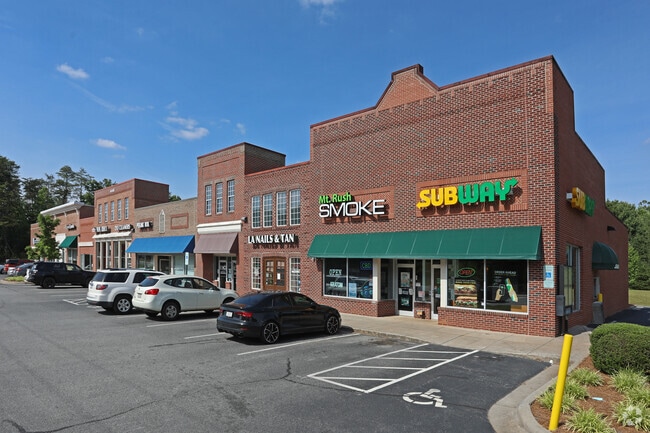
4436 Us Highway 220 N
Greensboro-High Point, NC
Rayle Heights
0145992
SUBWAY/PAPA JOHNS/EDWARDJONES HWY 220
Storebuilding
Guilford
X
North Carolina
3710783800J
6
2024
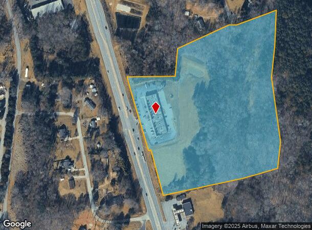
16.59 AC
2025
NW Guilford County
015800
Greensboro/Winston-Salem
17,640 SF
DEMOGRAPHICS near 4436 Us Highway 220 N
1 Mile
3 Mile
5 Mile
2024 Total Population
1,508
11,871
53,664
2029 Population
1,497
11,786
53,276
Pop Growth 2024-2029
(0.73%)
(0.72%)
(0.72%)
Average Age
42
42
41
2024 Total Households
538
4,397
21,927
HH Growth 2024-2029
(0.74%)
(0.73%)
(0.78%)
Median Household Inc
$113,392
$118,761
$93,323
Avg Household Size
2.80
2.70
2.40
2024 Avg HH Vehicles
2.00
2.00
2.00
Median Home Value
$431,000
$406,938
$302,356
Median Year Built
1995
1997
1993
Nearby Places
Map Layers
Map Styles
 Street
 Aerial
- Restaurants
- Banks
- Shops
- Fitness
- Groceries
PUBLIC TRANSPORTATION
AIRPORT
Piedmont Triad International
DRIVE
WALK
Distance
Piedmont Triad International
18 min
9.4 mi
SALE & LEASE HISTORY
LISTING DATE
SALE/LEASE

Sep 25, 2016
For Lease
Jan 24, 2019
For Lease
Nearby Properties
Address
Land Use
TOTAL SIZE
Lot Size
Zoning
Address
Land Use
TOTAL SIZE
Lot Size
Zoning
317,844 SF
17.10 AC
PUD
Address
Land Use
TOTAL SIZE
Lot Size
Zoning
134,391 SF
19 AC
O
Address
Land Use
TOTAL SIZE
Lot Size
Zoning
249,702 SF
15.39 AC
PUD
Address
Land Use
TOTAL SIZE
Lot Size
Zoning
74,144 SF
14.28 AC
PUD
Address
Land Use
TOTAL SIZE
Lot Size
Zoning
54,260 SF
18.91 AC
RS-30
Address
Land Use
TOTAL SIZE
Lot Size
Zoning
24,910 SF
96.01 AC
PI
Address
Land Use
TOTAL SIZE
Lot Size
Zoning
74,348 SF
11.02 AC
CU-PI
Address
Land Use
TOTAL SIZE
Lot Size
Zoning
51,166 SF
17.73 AC
R-3
Address
Land Use
TOTAL SIZE
Lot Size
Zoning
90,000 SF
5.46 AC
LI
Address
Land Use
TOTAL SIZE
Lot Size
Zoning
52,167 SF
27.97 AC
RS-30
Address
Land Use
TOTAL SIZE
Lot Size
Zoning
38,926 SF
25.65 AC
GB
Address
Land Use
TOTAL SIZE
Lot Size
Zoning
4,511 SF
463.69 AC
AG
Address
Land Use
TOTAL SIZE
Lot Size
Zoning
2,191 SF
43.13 AC
GB
Address
Land Use
TOTAL SIZE
Lot Size
Zoning
56,095 SF
26.64 AC
PI
Address
Land Use
TOTAL SIZE
Lot Size
Zoning
42,298 SF
4.94 AC
HB
Address
Land Use
TOTAL SIZE
Lot Size
Zoning
14,676 SF
2.31 AC
HB
Address
Land Use
TOTAL SIZE
Lot Size
Zoning
280.47 AC
R-3
Address
Land Use
TOTAL SIZE
Lot Size
Zoning
20,939 SF
4.61 AC
PI
Address
Land Use
TOTAL SIZE
Lot Size
Zoning
5,913 SF
5.61 AC
RS-30
Address
Land Use
TOTAL SIZE
Lot Size
Zoning
13,547 SF
11.95 AC
HB
Address
Land Use
TOTAL SIZE
Lot Size
Zoning
2,097 SF
145.27 AC
AG
Address
Land Use
TOTAL SIZE
Lot Size
Zoning
14,442 SF
7.96 AC
R-3
Address
Land Use
TOTAL SIZE
Lot Size
Zoning
10,502 SF
1.44 AC
LB
Address
Land Use
TOTAL SIZE
Lot Size
Zoning
34,903 SF
11.17 AC
PI
Address
Land Use
TOTAL SIZE
Lot Size
Zoning
45,131 SF
8.37 AC
AG
Address
Land Use
TOTAL SIZE
Lot Size
Zoning
116.65 AC
AG
Address
Land Use
TOTAL SIZE
Lot Size
Zoning
2,512 SF
177.63 AC
CU-OSR
Address
Land Use
TOTAL SIZE
Lot Size
Zoning
972 SF
134.05 AC
AG
Address
Land Use
TOTAL SIZE
Lot Size
Zoning
9,831 SF
5 AC
LO
The World's #1 Commercial Real Estate Marketplace
Connect with us
© 2025 CoStar Group
The information above has been obtained from sources believed reliable. While we do not doubt its accuracy we have not verified it and make no guarantee, warranty or representation about it. It is your responsibility to independently confirm its accuracy and completeness. Any projections, opinions, assumptions, or estimates used are for example only and do not represent the current or future performance of the property. The value of this transaction to you depends on tax and other factors which should be evaluated by your tax, financial, and legal advisors. You and your advisors should conduct a careful, independent investigation of the property to determine to your satisfaction the suitability of the property for your needs.