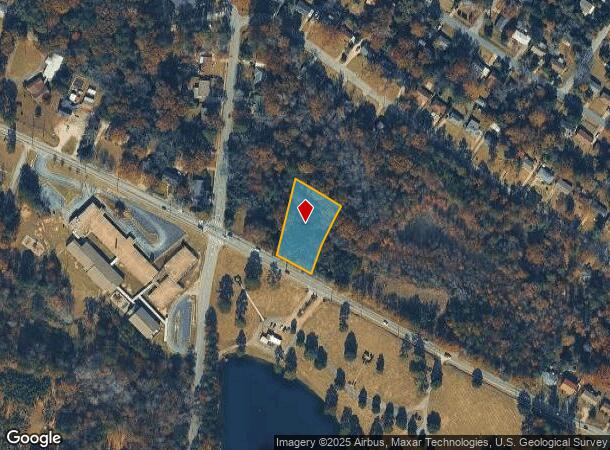
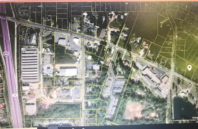
Property Record
4437 Saint Marys Rd, Columbus, GA 31907

NEARBY LISTINGS FOR SALE OR LEASE
Property Detail
4437 Saint Marys Rd
Columbus, GA-AL
Property Not In Sub-Division
089-042-022
PT LL 141 142 ST MARYS RD
Residentialacreage
Muscogee
X
Georgia
01113C0200C
1.04 AC
2025
Greater Columbus
2025
Columbus GA
010702
DEMOGRAPHICS near 4437 Saint Marys Rd
1 Mile
3 Mile
5 Mile
2024 Total Population
10,174
66,012
114,318
2029 Population
9,875
64,787
112,368
Pop Growth 2024-2029
(2.94%)
(1.86%)
(1.71%)
Average Age
40
37
37
2024 Total Households
4,195
25,730
45,746
HH Growth 2024-2029
(2.81%)
(1.83%)
(1.70%)
Median Household Inc
$44,427
$37,586
$41,262
Avg Household Size
2.40
2.50
2.40
2024 Avg HH Vehicles
2.00
2.00
2.00
Median Home Value
$140,202
$109,776
$134,636
Median Year Built
1980
1972
1970
Nearby Places
Map Layers
Map Styles
 Street
 Aerial
- Restaurants
- Banks
- Shops
- Fitness
- Groceries
PUBLIC TRANSPORTATION
AIRPORT
Columbus
DRIVE
WALK
Distance
Columbus
11 min
6.9 mi
Freight Ports
Port of Panama City
DRIVE
WALK
Distance
Port of Panama City
239 min
188.1 mi
SALE & LEASE HISTORY
LISTING DATE
SALE/LEASE

Sep 24, 2018
For Sale
Nearby Properties
Address
Land Use
TOTAL SIZE
Lot Size
Zoning
Address
Land Use
TOTAL SIZE
Lot Size
Zoning
Address
Land Use
TOTAL SIZE
Lot Size
Zoning
97,648 SF
17.40 AC
Address
Land Use
TOTAL SIZE
Lot Size
Zoning
5,592 SF
13.41 AC
Address
Land Use
TOTAL SIZE
Lot Size
Zoning
56,095 SF
25.91 AC
Address
Land Use
TOTAL SIZE
Lot Size
Zoning
4,802 SF
22.77 AC
Address
Land Use
TOTAL SIZE
Lot Size
Zoning
133,276 SF
36.76 AC
Address
Land Use
TOTAL SIZE
Lot Size
Zoning
247,570 SF
28.07 AC
Address
Land Use
TOTAL SIZE
Lot Size
Zoning
63.48 AC
Address
Land Use
TOTAL SIZE
Lot Size
Zoning
45,932 SF
29 AC
Address
Land Use
TOTAL SIZE
Lot Size
Zoning
78,948 SF
6 AC
Address
Land Use
TOTAL SIZE
Lot Size
Zoning
53.77 AC
Address
Land Use
TOTAL SIZE
Lot Size
Zoning
90.59 AC
Address
Land Use
TOTAL SIZE
Lot Size
Zoning
5,686 SF
17.64 AC
Address
Land Use
TOTAL SIZE
Lot Size
Zoning
48,100 SF
9 AC
Address
Land Use
TOTAL SIZE
Lot Size
Zoning
5,508 SF
61.13 AC
Address
Land Use
TOTAL SIZE
Lot Size
Zoning
4,538 SF
22.18 AC
Address
Land Use
TOTAL SIZE
Lot Size
Zoning
5,414 SF
17.11 AC
Address
Land Use
TOTAL SIZE
Lot Size
Zoning
5,514 SF
15.28 AC
Address
Land Use
TOTAL SIZE
Lot Size
Zoning
32,202 SF
8.42 AC
Address
Land Use
TOTAL SIZE
Lot Size
Zoning
30,375 SF
33.14 AC
Address
Land Use
TOTAL SIZE
Lot Size
Zoning
161,162 SF
14.79 AC
Address
Land Use
TOTAL SIZE
Lot Size
Zoning
4,409 SF
10.80 AC
Address
Land Use
TOTAL SIZE
Lot Size
Zoning
13,440 SF
16.32 AC
Address
Land Use
TOTAL SIZE
Lot Size
Zoning
5,592 SF
20.16 AC
Address
Land Use
TOTAL SIZE
Lot Size
Zoning
14,223 SF
6.80 AC
Address
Land Use
TOTAL SIZE
Lot Size
Zoning
58,831 SF
12.18 AC
Address
Land Use
TOTAL SIZE
Lot Size
Zoning
30.19 AC
Address
Land Use
TOTAL SIZE
Lot Size
Zoning
35.78 AC
Address
Land Use
TOTAL SIZE
Lot Size
Zoning
288,635 SF
32.01 AC
Address
Land Use
TOTAL SIZE
Lot Size
Zoning
41,472 SF
19.16 AC
The World's #1 Commercial Real Estate Marketplace
Connect with us
© 2025 CoStar Group
The information above has been obtained from sources believed reliable. While we do not doubt its accuracy we have not verified it and make no guarantee, warranty or representation about it. It is your responsibility to independently confirm its accuracy and completeness. Any projections, opinions, assumptions, or estimates used are for example only and do not represent the current or future performance of the property. The value of this transaction to you depends on tax and other factors which should be evaluated by your tax, financial, and legal advisors. You and your advisors should conduct a careful, independent investigation of the property to determine to your satisfaction the suitability of the property for your needs.