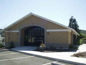
Property Record
4439 Appian Way, El Sobrante, CA 94803

NEARBY LISTINGS FOR SALE OR LEASE
Property Detail
4439 Appian Way
Oakland-Hayward-Berkeley, CA
Santa Rita Acres 02
425-110-021-2
SANTA RITA ACRES #2 POR LOT 154 & TR ADJ
Apartment
Contra Costa
AE
California
06013C0231G
154
2025
2.53 AC
2025
Richmond/San Pablo
363000
East Bay/Oakland
23,886 SF
DEMOGRAPHICS near 4439 Appian Way
1 Mile
3 Mile
5 Mile
2024 Total Population
15,867
139,092
257,172
2029 Population
15,731
137,582
254,680
Pop Growth 2024-2029
(0.86%)
(1.09%)
(0.97%)
Average Age
41
41
40
2024 Total Households
5,601
46,428
86,452
HH Growth 2024-2029
(0.95%)
(1.15%)
(1.02%)
Median Household Inc
$97,323
$92,168
$92,214
Avg Household Size
2.70
2.90
2.90
2024 Avg HH Vehicles
2.00
2.00
2.00
Median Home Value
$703,305
$704,260
$730,085
Median Year Built
1966
1965
1966
Nearby Places
Map Layers
Map Styles
 Street
 Aerial
- Restaurants
- Banks
- Shops
- Fitness
- Groceries
PUBLIC TRANSPORTATION
COMMUTER RAIL
Richmond (Capitol Corridor - Capitol Corridor Joint Powers Authority)
DRIVE
WALK
Distance
Richmond (Capitol Corridor - Capitol Corridor Joint Powers Authority)
10 min
5.3 mi
Berkeley (Capitol Corridor - Amtrak)
DRIVE
WALK
Distance
Berkeley (Capitol Corridor - Amtrak)
14 min
9.5 mi
AIRPORT
Metro Oakland International
DRIVE
WALK
Distance
Metro Oakland International
33 min
23.8 mi
San Francisco International
DRIVE
WALK
Distance
San Francisco International
45 min
31.5 mi
Freight Ports
Port of Richmond
DRIVE
WALK
Distance
Port of Richmond
19 min
10.0 mi
Nearby Properties
Address
Land Use
TOTAL SIZE
Lot Size
Zoning
Address
Land Use
TOTAL SIZE
Lot Size
Zoning
892,224 SF
46.87 AC
Address
Land Use
TOTAL SIZE
Lot Size
Zoning
252,714 SF
14.68 AC
C
Address
Land Use
TOTAL SIZE
Lot Size
Zoning
459,003 SF
21.30 AC
Address
Land Use
TOTAL SIZE
Lot Size
Zoning
179,961 SF
1.05 AC
Address
Land Use
TOTAL SIZE
Lot Size
Zoning
247,924 SF
14.36 AC
Address
Land Use
TOTAL SIZE
Lot Size
Zoning
245,680 SF
18.89 AC
Address
Land Use
TOTAL SIZE
Lot Size
Zoning
70,250 SF
9.55 AC
Address
Land Use
TOTAL SIZE
Lot Size
Zoning
220,864 SF
11.10 AC
Address
Land Use
TOTAL SIZE
Lot Size
Zoning
190,471 SF
11.32 AC
Address
Land Use
TOTAL SIZE
Lot Size
Zoning
171,052 SF
12.06 AC
M3
Address
Land Use
TOTAL SIZE
Lot Size
Zoning
135,904 SF
7.12 AC
Address
Land Use
TOTAL SIZE
Lot Size
Zoning
14,722 SF
5.69 AC
Address
Land Use
TOTAL SIZE
Lot Size
Zoning
41,400 SF
6.32 AC
Address
Land Use
TOTAL SIZE
Lot Size
Zoning
177,724 SF
63.32 AC
M-2
Address
Land Use
TOTAL SIZE
Lot Size
Zoning
118,658 SF
8.57 AC
Address
Land Use
TOTAL SIZE
Lot Size
Zoning
178,277 SF
58.72 AC
Address
Land Use
TOTAL SIZE
Lot Size
Zoning
131,693 SF
7.47 AC
Address
Land Use
TOTAL SIZE
Lot Size
Zoning
61,875 SF
3.62 AC
Address
Land Use
TOTAL SIZE
Lot Size
Zoning
110,765 SF
2.67 AC
Address
Land Use
TOTAL SIZE
Lot Size
Zoning
60,196 SF
13.44 AC
Address
Land Use
TOTAL SIZE
Lot Size
Zoning
136,648 SF
13.27 AC
Address
Land Use
TOTAL SIZE
Lot Size
Zoning
85,225 SF
8.34 AC
Address
Land Use
TOTAL SIZE
Lot Size
Zoning
61,403 SF
8.38 AC
Address
Land Use
TOTAL SIZE
Lot Size
Zoning
97,116 SF
7.26 AC
Address
Land Use
TOTAL SIZE
Lot Size
Zoning
72,927 SF
3.47 AC
Address
Land Use
TOTAL SIZE
Lot Size
Zoning
6,440 SF
8.14 AC
Address
Land Use
TOTAL SIZE
Lot Size
Zoning
17,660 SF
1.99 AC
Address
Land Use
TOTAL SIZE
Lot Size
Zoning
53,000 SF
3.74 AC
Address
Land Use
TOTAL SIZE
Lot Size
Zoning
123,704 SF
6.72 AC
Address
Land Use
TOTAL SIZE
Lot Size
Zoning
12,707 SF
4.08 AC
The World's #1 Commercial Real Estate Marketplace
Connect with us
© 2026 CoStar Group
The information above has been obtained from sources believed reliable. While we do not doubt its accuracy we have not verified it and make no guarantee, warranty or representation about it. It is your responsibility to independently confirm its accuracy and completeness. Any projections, opinions, assumptions, or estimates used are for example only and do not represent the current or future performance of the property. The value of this transaction to you depends on tax and other factors which should be evaluated by your tax, financial, and legal advisors. You and your advisors should conduct a careful, independent investigation of the property to determine to your satisfaction the suitability of the property for your needs.