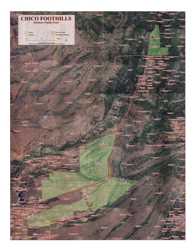
Property Record
4439 Highway 32, Chico, CA 95973
NEARBY LISTINGS FOR SALE OR LEASE
Property Detail
4439 Highway 32
Chico, CA
Map Twenty First Subdivision Of The Bidw
018-500-086-000
STATE HWY HUMBOLDT RD
Pasture
Butte
X
California
06007C0345E
229.52 AC
2024
Redding/Chico
2025
Other Market Areas
001300
DEMOGRAPHICS near 4439 Highway 32
1 Mile
3 Mile
5 Mile
2024 Total Population
93
9,042
45,567
2029 Population
92
8,740
43,778
Pop Growth 2024-2029
(1.08%)
(3.34%)
(3.93%)
Average Age
44
45
40
2024 Total Households
38
3,948
18,687
HH Growth 2024-2029
0.00%
(3.65%)
(4.14%)
Median Household Inc
$133,333
$104,245
$77,001
Avg Household Size
2.50
2.30
2.40
2024 Avg HH Vehicles
2.00
2.00
2.00
Median Home Value
$640,625
$539,013
$434,863
Median Year Built
2000
1995
1986
Nearby Places
Map Layers
Map Styles
 Street
 Aerial
- Restaurants
- Banks
- Shops
- Fitness
- Groceries
PUBLIC TRANSPORTATION
COMMUTER RAIL
Chico Amtrak (Coast Starlight - Amtrak)
DRIVE
WALK
Distance
Chico Amtrak (Coast Starlight - Amtrak)
9 min
5.2 mi
Freight Ports
Port of Stockton
DRIVE
WALK
Distance
Port of Stockton
162 min
134.3 mi
SALE & LEASE HISTORY
LISTING DATE
SALE/LEASE

Sep 24, 2016
For Sale
Nearby Properties
Address
Land Use
TOTAL SIZE
Lot Size
Zoning
Address
Land Use
TOTAL SIZE
Lot Size
Zoning
58,013 SF
7.08 AC
TND
Address
Land Use
TOTAL SIZE
Lot Size
Zoning
13,186 SF
4.97 AC
R2
Address
Land Use
TOTAL SIZE
Lot Size
Zoning
20,643 SF
3.32 AC
TND
Address
Land Use
TOTAL SIZE
Lot Size
Zoning
185,744 SF
10.15 AC
Address
Land Use
TOTAL SIZE
Lot Size
Zoning
21,216 SF
9.60 AC
CC
Address
Land Use
TOTAL SIZE
Lot Size
Zoning
104,992 SF
5.64 AC
CN
Address
Land Use
TOTAL SIZE
Lot Size
Zoning
141,333 SF
7.08 AC
Address
Land Use
TOTAL SIZE
Lot Size
Zoning
72,372 SF
1.90 AC
R3
Address
Land Use
TOTAL SIZE
Lot Size
Zoning
13,459 SF
3.61 AC
Address
Land Use
TOTAL SIZE
Lot Size
Zoning
160,214 SF
13.50 AC
Address
Land Use
TOTAL SIZE
Lot Size
Zoning
175,392 SF
14.83 AC
Address
Land Use
TOTAL SIZE
Lot Size
Zoning
99,180 SF
10.18 AC
OC
Address
Land Use
TOTAL SIZE
Lot Size
Zoning
90,400 SF
7.50 AC
Address
Land Use
TOTAL SIZE
Lot Size
Zoning
51,805 SF
2.50 AC
CN
Address
Land Use
TOTAL SIZE
Lot Size
Zoning
22,032 SF
8.66 AC
Address
Land Use
TOTAL SIZE
Lot Size
Zoning
145,000 SF
4.93 AC
R3
Address
Land Use
TOTAL SIZE
Lot Size
Zoning
74,180 SF
4.25 AC
00
Address
Land Use
TOTAL SIZE
Lot Size
Zoning
106,064 SF
8.66 AC
Address
Land Use
TOTAL SIZE
Lot Size
Zoning
143,362 SF
8.28 AC
CITY
Address
Land Use
TOTAL SIZE
Lot Size
Zoning
64,600 SF
2.15 AC
TND
Address
Land Use
TOTAL SIZE
Lot Size
Zoning
253,279 SF
6.49 AC
Address
Land Use
TOTAL SIZE
Lot Size
Zoning
55,463 SF
1.38 AC
CC
Address
Land Use
TOTAL SIZE
Lot Size
Zoning
72,530 SF
3.09 AC
Address
Land Use
TOTAL SIZE
Lot Size
Zoning
107,880 SF
8.60 AC
Address
Land Use
TOTAL SIZE
Lot Size
Zoning
22,594 SF
1.28 AC
Address
Land Use
TOTAL SIZE
Lot Size
Zoning
48,534 SF
3.49 AC
Address
Land Use
TOTAL SIZE
Lot Size
Zoning
9,120 SF
1.60 AC
TND
Address
Land Use
TOTAL SIZE
Lot Size
Zoning
52,500 SF
6.01 AC
R3
Address
Land Use
TOTAL SIZE
Lot Size
Zoning
23,884 SF
1.80 AC
TND
Address
Land Use
TOTAL SIZE
Lot Size
Zoning
31,422 SF
0.48 AC
The World's #1 Commercial Real Estate Marketplace
Connect with us
© 2026 CoStar Group
The information above has been obtained from sources believed reliable. While we do not doubt its accuracy we have not verified it and make no guarantee, warranty or representation about it. It is your responsibility to independently confirm its accuracy and completeness. Any projections, opinions, assumptions, or estimates used are for example only and do not represent the current or future performance of the property. The value of this transaction to you depends on tax and other factors which should be evaluated by your tax, financial, and legal advisors. You and your advisors should conduct a careful, independent investigation of the property to determine to your satisfaction the suitability of the property for your needs.