Property Record
10Th, Mcallen, TX 78501
This Property Is For Sale
NEARBY LISTINGS FOR SALE OR LEASE
Property Detail
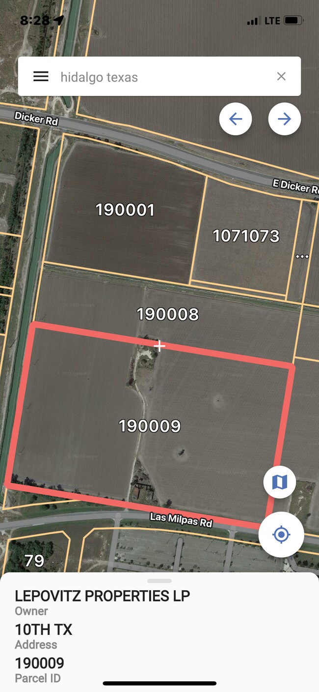
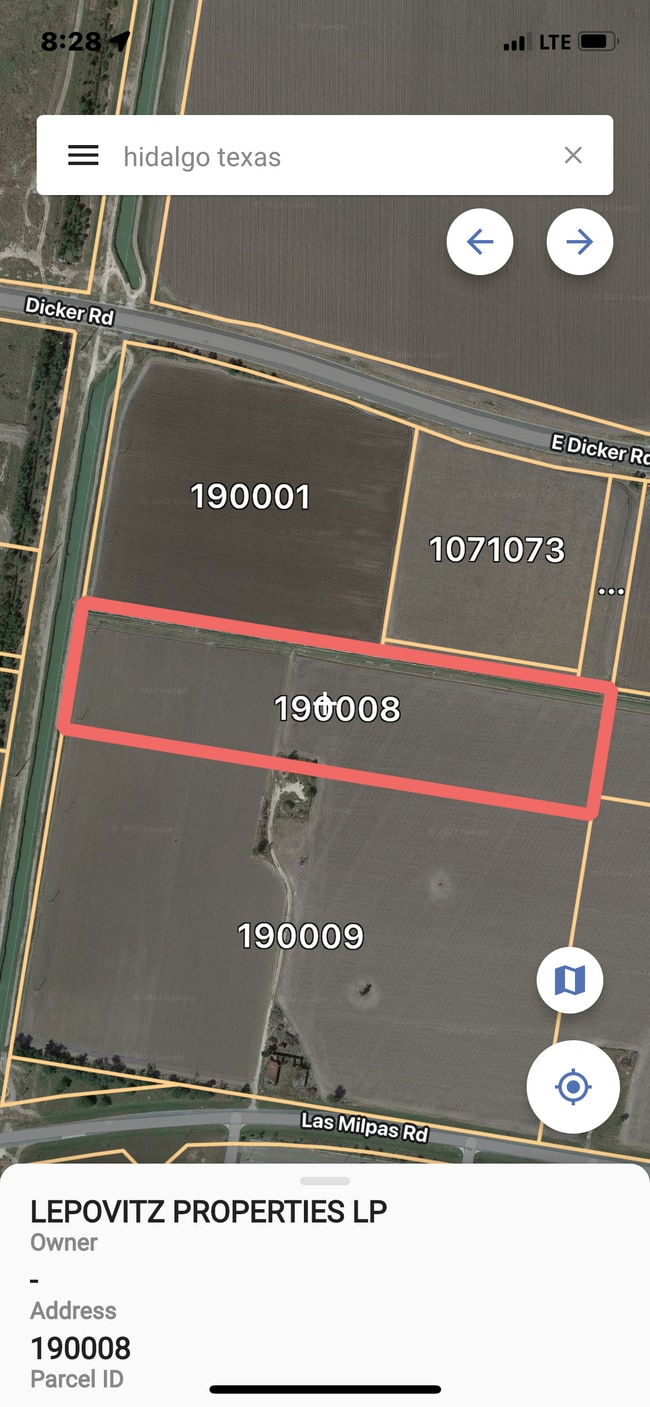
10Th
McAllen/Edinburg/Pharr
Hidalgo Canal Co-Vv - Svv
McAllen-Edinburg-Mission, TX
HIDALGO CANAL CO-VV IRR TR S764.38 EXC S647.32-E663.44 LOT 12 BLK 3 12.80AC GR 11.63AC NET
H2550-01-003-0013-05
Hidalgo
Privatepreserveopenspacevacantlandforestlandconservation
Texas
2024
12
2025
11.92 AC
000002
Greater McAllen
DEMOGRAPHICS near 10Th
1 Mile
3 Mile
5 Mile
2024 Total Population
292
31,016
93,001
2029 Population
303
32,409
97,930
Pop Growth 2024-2029
+ 3.77%
+ 4.49%
+ 5.30%
Average Age
34
33
34
2024 Total Households
84
8,084
27,252
HH Growth 2024-2029
+ 3.57%
+ 4.33%
+ 5.37%
Median Household Inc
$27,500
$38,934
$41,510
Avg Household Size
3.50
3.70
3.30
2024 Avg HH Vehicles
2.00
2.00
2.00
Median Home Value
$153,333
$120,031
$129,773
Median Year Built
2001
2001
2001
Nearby Places
Map Layers
Map Styles
 Street
 Aerial
- Restaurants
- Banks
- Shops
- Fitness
- Groceries
PUBLIC TRANSPORTATION
AIRPORT
McAllen International
DRIVE
WALK
Distance
McAllen International
8 min
4.8 mi
Freight Ports
Port of Brownsville
DRIVE
WALK
Distance
Port of Brownsville
74 min
64.4 mi
Nearby Properties
Address
Land Use
TOTAL SIZE
Lot Size
Zoning
Address
Land Use
TOTAL SIZE
Lot Size
Zoning
16,600 SF
23.27 AC
Address
Land Use
TOTAL SIZE
Lot Size
Zoning
105,440 SF
19.84 AC
Address
Land Use
TOTAL SIZE
Lot Size
Zoning
287,691 SF
33.57 AC
Address
Land Use
TOTAL SIZE
Lot Size
Zoning
73,920 SF
21.13 AC
Address
Land Use
TOTAL SIZE
Lot Size
Zoning
158,844 SF
36.09 AC
Address
Land Use
TOTAL SIZE
Lot Size
Zoning
73,507 SF
23.84 AC
Address
Land Use
TOTAL SIZE
Lot Size
Zoning
19.09 AC
Address
Land Use
TOTAL SIZE
Lot Size
Zoning
323,400 SF
17.29 AC
Address
Land Use
TOTAL SIZE
Lot Size
Zoning
370,000 SF
24.54 AC
Address
Land Use
TOTAL SIZE
Lot Size
Zoning
215,000 SF
17.80 AC
Address
Land Use
TOTAL SIZE
Lot Size
Zoning
128,660 SF
19.35 AC
Address
Land Use
TOTAL SIZE
Lot Size
Zoning
288,657 SF
16.75 AC
IN
Address
Land Use
TOTAL SIZE
Lot Size
Zoning
180,548 SF
21.62 AC
Address
Land Use
TOTAL SIZE
Lot Size
Zoning
285,360 SF
13.67 AC
CO
Address
Land Use
TOTAL SIZE
Lot Size
Zoning
352,000 SF
18 AC
Address
Land Use
TOTAL SIZE
Lot Size
Zoning
370,736 SF
16.52 AC
Address
Land Use
TOTAL SIZE
Lot Size
Zoning
210,045 SF
19.39 AC
RM
Address
Land Use
TOTAL SIZE
Lot Size
Zoning
240,292 SF
38.55 AC
RS
Address
Land Use
TOTAL SIZE
Lot Size
Zoning
73,446 SF
39.27 AC
Address
Land Use
TOTAL SIZE
Lot Size
Zoning
216,116 SF
13.21 AC
IN
Address
Land Use
TOTAL SIZE
Lot Size
Zoning
131,496 SF
13.13 AC
RM
Address
Land Use
TOTAL SIZE
Lot Size
Zoning
86,220 SF
40.55 AC
Address
Land Use
TOTAL SIZE
Lot Size
Zoning
232,385 SF
10.44 AC
Address
Land Use
TOTAL SIZE
Lot Size
Zoning
180,971 SF
10.16 AC
IN
Address
Land Use
TOTAL SIZE
Lot Size
Zoning
216,237 SF
11.74 AC
Address
Land Use
TOTAL SIZE
Lot Size
Zoning
1 SF
23.25 AC
Address
Land Use
TOTAL SIZE
Lot Size
Zoning
203,413 SF
11.83 AC
RM
Address
Land Use
TOTAL SIZE
Lot Size
Zoning
171,046 SF
8.64 AC
CO
Address
Land Use
TOTAL SIZE
Lot Size
Zoning
109,282 SF
6.95 AC
Address
Land Use
TOTAL SIZE
Lot Size
Zoning
143,420 SF
8.51 AC
The World's #1 Commercial Real Estate Marketplace
Connect with us
© 2026 CoStar Group
The information above has been obtained from sources believed reliable. While we do not doubt its accuracy we have not verified it and make no guarantee, warranty or representation about it. It is your responsibility to independently confirm its accuracy and completeness. Any projections, opinions, assumptions, or estimates used are for example only and do not represent the current or future performance of the property. The value of this transaction to you depends on tax and other factors which should be evaluated by your tax, financial, and legal advisors. You and your advisors should conduct a careful, independent investigation of the property to determine to your satisfaction the suitability of the property for your needs.